Jumbosa: Difference between revisions
No edit summary |
No edit summary |
||
| Line 51: | Line 51: | ||
Jumbosa is a confederative republic and a parliamentary democracy, with legislative power vested in the 113-member unicameral Parlament. It is a confederation, currently divided into 3 federal states, 14 counties and 67 municipalities. Jumbosa ranks very highly in protection of civil liberties, economic competitiveness, prosperity and human development, even though they have been criticized for their privatized healthcare, privatized educational system and a low income equality. | Jumbosa is a confederative republic and a parliamentary democracy, with legislative power vested in the 113-member unicameral Parlament. It is a confederation, currently divided into 3 federal states, 14 counties and 67 municipalities. The 3 federal states have large juridical power when it comes to domestic issues, and all federal states have their regional parliaments(legislative power), called Parledrale, lead by an Etat Gouverneur elected by the said regional Parledrale. Jumbosa ranks very highly in protection of civil liberties, economic competitiveness, prosperity and human development, even though they have been criticized for their privatized healthcare, privatized educational system and a low income equality. | ||
Revision as of 16:39, 25 November 2021
Confederation of Jumbosa "Confédération des Jumbése" | |
|---|---|
|
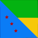
Flag | |
| Motto: "Mother Sea and Father land shall lead me to Paradise my home" | |
| Anthem: ""Oh Sun, shine thyn light on min fields"" | |
 Map of Confederation of Jumbosa | |
| Capital | Port Joseph(2010-2025) |
| Largest city | Albertine |
| Official languages | Lémanche, Laruba |
| Recognised regional languages | Zamu´hu |
| Ethnic groups (2020) | Lémanche-Jumbosians(39%), Laruba-Jumbosians(19%), Lémanchenié(11%), Other(13%), Larubian(8%), Zawu´hili(7%), insert later(3%) |
| Demonym(s) | Jumbosian |
| Government | Democratic Parliamentarian Republic |
| Emmanuel Joseph | |
| Jospin Ramsamy | |
| Legislature | Jumbosian Parliament |
| Independence [from insert country later] | |
| Population | |
• 2020 estimate | 2.7 million |
| Currency | Jumbosian Hamba |
| Date format | dd-mm-yyyy |
| Driving side | right |
| Calling code | +72 |
| Internet TLD | .jm |
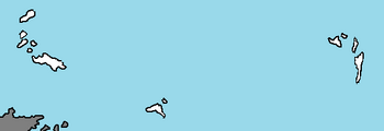
Jubosa, officially known as the Confederation of Jumbosa (Lémanche: Confederation des Jumbése) is a democratic confederative parliamentarian republic located on the continent of Nortua in the Coalition of Crown Albatross. It has maritime borders with Utobania and Trive to the north, Siniapore to the northwest, and Great Epsilon to the south. The confederation consists of three Etat fédérals, Sainte-Marie, Victoire and Des Mann. The capital is Port Joseph(between 2010 and 2025), while the largest city is Albertine. Jumbosa has a total population of 2.7 million. 67% of Jumbosians live in urban areas, which cover 1.3% of the entire land area. The highest concentration is in the western Etat fédéral Sainte-Marie and the central Etat fédéral Victoire.
Jumbosa is a confederative republic and a parliamentary democracy, with legislative power vested in the 113-member unicameral Parlament. It is a confederation, currently divided into 3 federal states, 14 counties and 67 municipalities. The 3 federal states have large juridical power when it comes to domestic issues, and all federal states have their regional parliaments(legislative power), called Parledrale, lead by an Etat Gouverneur elected by the said regional Parledrale. Jumbosa ranks very highly in protection of civil liberties, economic competitiveness, prosperity and human development, even though they have been criticized for their privatized healthcare, privatized educational system and a low income equality.
Jumbosa is a series of multiple archipelagos which extend from 180 miles north of central Adula to the range of the Utobanian peninsula in the Nortua Sea, classifying it as an extension of central Nortua despite relative ambiguity and interpretation from geological experts. Nouvile is the largest island and most populous, being home to the capital of Albertine, while Swunata is the second largest. Other notable islands include Tomasique, Remeaux, and Les Paradia. There are at least 300 islands in the chains. The climate can be mild and wet or very dry, because of the north-east trade winds. The individual islands in the Jumbosa archipelagos tend to have distinct microclimates and the classifications range mainly from semi-arid to desert.
Like other island nations, Jumbosa faces unique environmental issues created by its proximity to the ocean, and small size. These include pressures on water resources, natural ecosystems, and deforestation more generally. Existing issues on the island are further made worse by climate change, where, unlike other island nations affected by climate change, sea level rise, increased weather variability, create increased pressures on the communities on the islands and the land, through processes like coastal erosion and saltwater intrusion.
Etymology
The name Jumbése is a fairly new word, and it was created for the creation of the confederacy, because the signers of the Albertine treaty didn't want to alienate any of the islands' inhabitants by picking an already existing name. According to several books and interviews with people who signed the treaty, was the name Jumbése created by combining the Lémanche word for alliance("Jemaine") and the Zwutana word for island("Bunsa"). Jumbése therefore literally translates to Alliance Islands, and means Alliance of Islands.
History
Geography
Jumbosa is a series of multiple archipelagos which extend from 180 miles north of central Adula to the range of the Utobanian peninsula in the Nortua Sea, classifying it as an extension of central Nortua despite relative ambiguity and interpretation from geological experts. -- is the largest island and most populous, being home to the capital of Albertine, while -- is the second largest. Other notable islands include --, --, and --. There are at least 300 islands in the chains.
Climate
According to the position of the islands with respect to the north-east trade winds, the climate can be mild and wet or very dry. Several native species form laurisilva forests. As a consequence, the individual islands in the Jumbosa archipelagos tend to have distinct microclimates. Those islands such as --, --, and -- lying to the west of the archipelago have a climate which is influenced by the moist Siniapore Current. They are well vegetated even at low levels and have extensive tracts of sub-tropical laurisilva forest. As one travels west toward the Nortuan coast, the influence of the current diminishes, and the islands become increasingly arid. The climate is subtropical (tropical at the coastline) and generally semidesertic, moderated by the sea and in summer by the trade winds. There are a number of microclimates and the classifications range mainly from semi-arid to desert. There also exists a subtropical humid climate which is very influenced by the sea in the middle of the islands of --, --, and --, where laurisilva cloud forests grow.
Environment
Like other island nations, Jumbosa faces unique environmental issues created by its proximity to the ocean, and small size. These include pressures on water resources, natural ecosystems, and deforestation more generally. Existing issues on the island are further made worse by climate change, where, unlike other island nations affected by climate change, sea level rise, increased weather variability, create increased pressures on the communities on the islands and the land, through processes like coastal erosion and saltwater intrusion.
