South Vestelia: Difference between revisions
(Created page with "{{WIP}}{{Infobox settlement |name = South Vestelia |native_name = Sør-Vestelia |native_name_lang = <!-- ISO 639-1 code e.g. "fr" for Fre...") |
No edit summary |
||
| Line 14: | Line 14: | ||
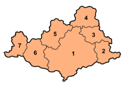
|map_caption = '''Settlements with the South Vestelia metropolitan area:'''<br>'''1:''' [[Kalstad]] '''2:''' [[Scovern|Gardenset]] '''3:''' [[Scovern|Bragernes]] '''4:''' [[Scovern|Rutskirke]] '''5:''' [[Scovern|Heum]] '''6:''' [[Scovern|Polmak{{ndash}}Valanhamn]] '''7:''' [[Scovern|Selvik]] | |map_caption = '''Settlements with the South Vestelia metropolitan area:'''<br>'''1:''' [[Kalstad]] '''2:''' [[Scovern|Gardenset]] '''3:''' [[Scovern|Bragernes]] '''4:''' [[Scovern|Rutskirke]] '''5:''' [[Scovern|Heum]] '''6:''' [[Scovern|Polmak{{ndash}}Valanhamn]] '''7:''' [[Scovern|Selvik]] | ||
|population_as_of = 2014 | |population_as_of = 2014 | ||
|population_total = 1,876,928<ref name="SV stats">[https://www.youtube.com/watch?v=cGUAp_xoi4o"Sør-Vestisk befolkningsstatistikk"]. ''Sør-Vestisk storbyråd''. 19 January 2014. Retrieved 30 April 2023</ref> | |population_total = 1,876,928<ref name="SV stats">[https://www.youtube.com/watch?v=cGUAp_xoi4o"Sør-Vestisk befolkningsstatistikk"]. ''Sør-Vestisk storbyråd''. 19 January 2014. Retrieved 30 April 2023</ref><ref name ="census">[https://iiwiki.us/wiki/Scovern#Largest_cities"2014 folketælling"]. ''SSI''. 19 January 2014. Retrieved 30 April 2023.</ref> | ||
|subdivision_type = Country | |subdivision_type = Country | ||
|subdivision_name = {{flag|Scovern}} | |subdivision_name = {{flag|Scovern}} | ||
| Line 42: | Line 42: | ||
}} | }} | ||
'''South Vestelia''' ({{wp|Norwegian language|Vestelian}}: ''Sør-Vestelia''), officially the '''South Vestelia Metropolitan Area''' (Vestelian: ''Sør-Vestisk storbysområde'') is a {{wp|metropolitan area}} in [[Vestelia]], [[Scovern]]. The second-largest urban area in the country, South Vestelia consists of the settlements of [[Kalstad]] (the second-largest city in Scovern), [[Scovern|Gardenset]], [[Scovern|Heum]], [[Scovern|Bragernes]], [[Scovern|Rutskirke]], [[Scovern|Polmak]], [[Scovern|Valanhamn]] and [[Scovern|Selvik]]. | '''South Vestelia''' ({{wp|Norwegian language|Vestelian}}: ''Sør-Vestelia''), officially the '''South Vestelia Metropolitan Area''' (Vestelian: ''Sør-Vestisk storbysområde'') is a {{wp|metropolitan area}} in [[Vestelia]], [[Scovern]]. The second-largest urban area in the country<ref name=census/>, South Vestelia consists of the settlements of [[Kalstad]] (the second-largest city in Scovern), [[Scovern|Gardenset]], [[Scovern|Heum]], [[Scovern|Bragernes]], [[Scovern|Rutskirke]], [[Scovern|Polmak]], [[Scovern|Valanhamn]] and [[Scovern|Selvik]]. | ||
South Vestelia is a significant economic centre for both Vestelia and Scovern, and since {{wp|federalisation}} has experienced significant population and economic growth. The [[World City Studies Institute]] ranks South Vestelia as a third-rate city as of 2021<ref>[https://iiwiki.us/wiki/World_City_Studies_Institute#World_Cities_Index"World Cities Index"]. ''World City Studies Institute''. 19 April 2021. Retrieved 30 April 2023.</ref>, with new developments within the area, particularly at [[Scovern|Kalstadshavn]], aiming to make the city an attractive destination for global businesses. | |||
== Notes == | == Notes == | ||
Revision as of 14:02, 30 April 2023
This article is incomplete because it is pending further input from participants, or it is a work-in-progress by one author. Please comment on this article's talk page to share your input, comments and questions. Note: To contribute to this article, you may need to seek help from the author(s) of this page. |
South Vestelia
Sør-Vestelia | |
|---|---|
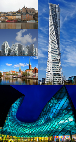
 Clockwise from top-left: Kalstad Old Town overlooking the River Modens • Helix Tower • Lagune in Rutskirke, the largest shopping mall in Scovern • Selvik town centre • modern developments at Kalstadshavn | |
 | |
| Country | |
| Nation | Vestelia |
| Government | |
| • Body | South Vestelian Metropolitan Council (SVSR) |
| • Mayor | Jim Jan Veierod (SAP) |
| • Government | SAP |
| • Rigsdagen seats | 13 (of 318) |
| Area | |
| • Total | 471.64 km2 (182.10 sq mi) |
| Population (2014) | |
| • Total | 1,876,928[1][2] |
| Demonym(s) | South Vestelian, Sør-Vestisk[a] |
| Time zone | UTC+0 (Euclean Standard Time) |
| ISO 3166 code | SK-SV |
| GRP (nominal) | €104 billion[3][4] |
| GRP per capita | €55,671[3] |
| HDI (2019) | 0.963[5] |
South Vestelia (Vestelian: Sør-Vestelia), officially the South Vestelia Metropolitan Area (Vestelian: Sør-Vestisk storbysområde) is a metropolitan area in Vestelia, Scovern. The second-largest urban area in the country[2], South Vestelia consists of the settlements of Kalstad (the second-largest city in Scovern), Gardenset, Heum, Bragernes, Rutskirke, Polmak, Valanhamn and Selvik. South Vestelia is a significant economic centre for both Vestelia and Scovern, and since federalisation has experienced significant population and economic growth. The World City Studies Institute ranks South Vestelia as a third-rate city as of 2021[6], with new developments within the area, particularly at Kalstadshavn, aiming to make the city an attractive destination for global businesses.
Notes
- 1. ^ Uncommon in general use over demonyms of individual settlements
References
- ↑ "Sør-Vestisk befolkningsstatistikk". Sør-Vestisk storbyråd. 19 January 2014. Retrieved 30 April 2023
- ↑ 2.0 2.1 "2014 folketælling". SSI. 19 January 2014. Retrieved 30 April 2023.
- ↑ 3.0 3.1 "Sør-Vestisk økonomisk statistikk". Sør-Vestisk storbyråd. 12 January 2019. Retrieved 30 April 2023
- ↑ "Kalstad overgår BNP på 100 milliarder euro". Dagbladet Kiprien. 17 April 2016. Retrieved 30 April 2023
- ↑ "Index des membres de l'ACDE: Scoverne". Association for Economic Development and Cooperation. 28 March 2020. Retrived 30 April 2023
- ↑ "World Cities Index". World City Studies Institute. 19 April 2021. Retrieved 30 April 2023.