Torúmalana: Difference between revisions
mNo edit summary |
mNo edit summary |
||
| Line 12: | Line 12: | ||
| elevation_m = 5711 | | elevation_m = 5711 | ||
| prominence = | | prominence = | ||
| prominence_m = | | prominence_m = 5711 | ||
| isolation = | | isolation = | ||
| isolation_km = | | isolation_km = | ||
| Line 33: | Line 33: | ||
}} | }} | ||
'''Torúmalana''' ([[Ahéri language|Ahéri]] pronunciation: {{IPAc-en|t|oʊ|ˈ|r|u|m|aː|l|aː|n|aː|}}) is a mountain in the , a range of the [[Vekra Retiqa]] cordillera, in [[Hysera]]'s [[Zha'tar]] province. It is the highest point in [[Teudallum]], the highest point in Western [[Astyria]] and the highest volcano in the region. Its peak reaches a height of {{convert|5711|m|ft}}. | '''Torúmalana''' ([[Ahéri language|Ahéri]] pronunciation: {{IPAc-en|t|oʊ|ˈ|r|u|m|aː|l|aː|n|aː|}}) is a mountain in the , a range of the [[Vekra Retiqa]] cordillera, in [[Hysera]]'s [[Zha'tar]] province. It is the highest point in [[Teudallum]], the highest point in Western [[Astyria]] and the highest volcano in the region. Its peak reaches a height of {{convert|5711|m|ft}}, which is also the mountain's prominence, as there is no higher point on the continent. It is therefore the second-most prominent peak in Astyria, after [[Mount Aeneas]] in [[Ixalia]]. | ||
Torúmalana's snow- and ice-covered peak rises {{convert|2314|m|ft}} above the surrounding tundra, {{convert|76|km|mi|}} east-by-southeast of the provincial capital at [[Ludef]]. The mountain stands in the centre of the expansive [[Ludef Plateau]], which is one of the highest plateaux in Astyria, with average elevations about {{convert|3300-3500|m|ft}}. | Torúmalana's snow- and ice-covered peak rises {{convert|2314|m|ft}} above the surrounding tundra, {{convert|76|km|mi|}} east-by-southeast of the provincial capital at [[Ludef]]. The mountain stands in the centre of the expansive [[Ludef Plateau]], which is one of the highest plateaux in Astyria, with average elevations about {{convert|3300-3500|m|ft}}. | ||
Revision as of 00:38, 24 February 2024
| Torúmalana | |
|---|---|
 | |
| Highest point | |
| Elevation | 5,711 m (18,737 ft) |
| Prominence | 5,711 m (18,737 ft) |
| Listing | Country high point Provincial top Ultra Haele-Rismikhar |
| Naming | |
| Pronunciation | /toʊˈrumɑːlɑːnɑː/ |
| Geography | |
| Parent range | (Vekra Retiqa cordillera) |
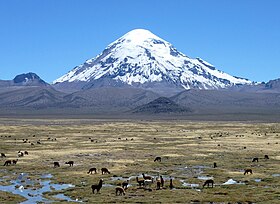
Torúmalana (Ahéri pronunciation: /toʊˈrumɑːlɑːnɑː/) is a mountain in the , a range of the Vekra Retiqa cordillera, in Hysera's Zha'tar province. It is the highest point in Teudallum, the highest point in Western Astyria and the highest volcano in the region. Its peak reaches a height of 5,711 metres (18,737 ft), which is also the mountain's prominence, as there is no higher point on the continent. It is therefore the second-most prominent peak in Astyria, after Mount Aeneas in Ixalia.
Torúmalana's snow- and ice-covered peak rises 2,314 metres (7,592 ft) above the surrounding tundra, 76 kilometres (47 mi) east-by-southeast of the provincial capital at Ludef. The mountain stands in the centre of the expansive Ludef Plateau, which is one of the highest plateaux in Astyria, with average elevations about 3,300–3,500 metres (10,800–11,500 ft).
Geology
Torúmalana is a volcanic summit, initially formed by the convergent interaction of the Arithemlan plate (now part of the Mederano plate) with the Jajexan and Parthenopean plates. The resulting subduction zone, as the Jajexan plate sank under the Arithemlan plate, created rising magma plumes within the mantle that formed numerous volcanos across northern Trellin. Torúmalana is a stratovolcano that may be dormant or extinct. It is not thought to have erupted in the past ten thousand years,
Fauna
Flora
Ascents
Deaths
- 2024, February —
 Aquitaynian screenwriter Duder Astyrianus was discovered by Zhaatarti mountain rescue affiliated to the Royal Society of Medics. He was reportedly frozen to a "a rather large geode" and dressed in "nothing but a frock."