Administrative Divisions of Kapuku: Difference between revisions
Jump to navigation
Jump to search
(Created page with "thumb|Left|Provincial Map of Kapuku The Kingdom of Kapuku is split into a total of 5 self governing administrative divisions. Each divi...") |
No edit summary |
||
| Line 40: | Line 40: | ||
|[[Liuwahi]] | |[[Liuwahi]] | ||
|- | |- | ||
{{Template:Kapuku NavBox}} | |||
[[Category: | {{Template:INWU}} | ||
[[Category:Kapuku]] | |||
[[Category:INWU]] | |||
Latest revision as of 05:27, 27 March 2020
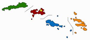
The Kingdom of Kapuku is split into a total of 5 self governing administrative divisions. Each division has its own capital, flag, Ali'i, etc. These 5 divisions are The Limoni Division, The Huamea Division, The Lono Division (The nations capital which acts as its own division apart from Limoni), The Ulukau Division, and The Hulawa Division. Each divison (Apart from Lono and Limoni) is an island or group of islands, named after their main island. Each division gets a certain amount of representitives in The House of Representitives based on each 100,000 people living in the division. The divisions were first designated in the 1946 Consitution after a coup in Kapuku in 1946.
| Rank by 2020 Estimates | State or territory | License Plate Code/Postal Code | Population estimate 2020 | Capital |
|---|---|---|---|---|
| 1 | LI/LIM | 2,767,524 | Kanakai | |
| 2 | HA/HAU | 1,565,497 | Lahule | |
| 3 | LO/LON | 1,194,934 | Lono | |
| 4 | UL/ULU | 854,617 | Huahale | |
| 5 | HU/HUL | 716,171 | Liuwahi |
| History | ||
|---|---|---|
| Geography | ||
| Government and Politics | ||
| Subdivisions | ||
| Military | ||
| Economy | ||
| Culture | ||
Region: INWU | ||


