Vermrike: Difference between revisions
Jump to navigation
Jump to search
No edit summary |
No edit summary |
||
| Line 151: | Line 151: | ||
'''Vermrike''', officially '''The Kingdom of Vermrike''' (Vermrish: ''Konungariket Vermrike'') is a country in TBD. Vermrike is a constitutional monarchy and a parliamentary democracy, with legislative power vested in the 549-member unicameral Riksting. It is a unitary state, currently divided into 28 counties and 311 municipalities. Vermrike maintains a social welfare system that provides universal health care and tertiary education for its citizens. | '''Vermrike''', officially '''The Kingdom of Vermrike''' (Vermrish: ''Konungariket Vermrike'') is a country in TBD. Vermrike is a constitutional monarchy and a parliamentary democracy, with legislative power vested in the 549-member unicameral Riksting. It is a unitary state, currently divided into 28 counties and 311 municipalities. Vermrike maintains a social welfare system that provides universal health care and tertiary education for its citizens. | ||
=== Administrative divisions === | |||
{| class="wikitable" | |||
|- | |||
!Map!!Name!!Capital!!Population!!Area | |||
|- | |||
| rowspan="14" |{{Ainin labelled map}} | |||
|- | |||
|[[Image:Baldern.png|22px|border]] Baldern||Västerholm||412,500||73,149 km² | |||
|- | |||
|[[Image:Gevnoe.png|22px|border]] Gevnö||Vallinge||112,319||72,716 km² | |||
|- | |||
|[[Image:Hoeglandet.png|22px|border]] Höglandet||Glimmeå||229,611||17,903 km² | |||
|- | |||
|[[Image:Lunneoyerne.png|22px|border]] Puffin Isles||Lunneborg||31,419||6,377 km² | |||
|- | |||
|[[Image:Mardal.png|22px|border]] Mardal||Simonshus||903,800||121,153 km² | |||
|- | |||
|[[Image:Merendelskog.png|22px|border]] Merendelskog||Skromå||601,131||133,153 km² | |||
|- | |||
|[[Image:Mangenberg.png|22px|border]] Mångenberg||Gustavshamn||331,080||115,064 km² | |||
|- | |||
|[[Image:Norncoa.png|22px|border]] Norn||Älvbro||412,033||69,606 km² | |||
|- | |||
|[[Image:Vildbotten.png|22px|border]] Vildbotten||Ragnarsborg||180,449||36,746 km² | |||
|- | |||
|[[Image:Varnadalen.png|22px|border]] Värnadalen||Erikstad||334,991||95,429 km² | |||
|- | |||
|[[Image:Vasterbrettland.png|22px|border]] Västerbrättland||Nyborg||1,811,431||107,015 km² | |||
|- | |||
|[[Image:Olmern.png|22px|border]] Ölmern||Malmstad||866,401||85,403 km² | |||
|- | |||
|[[Image:Osterbrettland.png|22px|]] Österbrättland||Kungskog||717,110||161,800 km² | |||
|- | |||
|} | |||
Revision as of 14:18, 16 March 2022
The Kingdom of Vermrike Konungariket Vermrike | |
|---|---|
| Motto: "Över berg og sjö, gjenom dal og lund. För konungen står våret land enigt." (tr.) "Over mountains and lakes, through valley and grove. For the king our nation stands united." | |
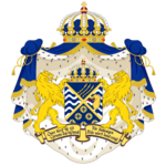
| Greater Coat of Arms | |
| Capital and largest city | Hovsborg |
| Official languages | Vermrish |
| Demonym(s) | Vermrish |
| Government | Unitary parliamentary constitutional monarchy |
• King | Anskar XI |
| Mikael Aloandersson | |
| Legislature | Riksdagen |
| Establishment | |
• TBD | TBD |
• TBD | TBD |
• TBD | TBD |
• TBD | TBD |
• Empire | August 12, 1567 |
• TBD | TBD |
• TBD | TBD |
• TBD | TBD |
• TBD | TBD |
| Area | |
• | [convert: invalid number] |
| Population | |
• Estimate | |
• TBD census | TBD |
• Density | [convert: invalid number] |
| GDP (PPP) | 2021 estimate |
• Total | |
• Per capita | |
| GDP (nominal) | 2017 estimate |
• Total | |
• Per capita | |
| Gini (2017) | medium (28th) |
| HDI (2020) | very high (26th) |
| Currency | Soravian Zolota (SRZ) |
| Time zone | UTC-2 to -3, +13 |
| Antipodes | Sunahamas Islands, Senria (from George Ruset Land) |
| Date format | yyyy/mm/dd |
| Driving side | right |
| Calling code | +72 |
| Internet TLD | |
| |
Vermrike, officially The Kingdom of Vermrike (Vermrish: Konungariket Vermrike) is a country in TBD. Vermrike is a constitutional monarchy and a parliamentary democracy, with legislative power vested in the 549-member unicameral Riksting. It is a unitary state, currently divided into 28 counties and 311 municipalities. Vermrike maintains a social welfare system that provides universal health care and tertiary education for its citizens.
Administrative divisions
| Map | Name | Capital | Population | Area |
|---|---|---|---|---|
| Template:Ainin labelled map | ||||
| Västerholm | 412,500 | 73,149 km² | ||
| Vallinge | 112,319 | 72,716 km² | ||
| Glimmeå | 229,611 | 17,903 km² | ||
| Lunneborg | 31,419 | 6,377 km² | ||
| Simonshus | 903,800 | 121,153 km² | ||
| Skromå | 601,131 | 133,153 km² | ||
| Gustavshamn | 331,080 | 115,064 km² | ||
| Älvbro | 412,033 | 69,606 km² | ||
| Ragnarsborg | 180,449 | 36,746 km² | ||
| Erikstad | 334,991 | 95,429 km² | ||
| Nyborg | 1,811,431 | 107,015 km² | ||
| Malmstad | 866,401 | 85,403 km² | ||
| Kungskog | 717,110 | 161,800 km² |


