Bonaventura: Difference between revisions
Jump to navigation
Jump to search
No edit summary |
No edit summary |
||
| Line 3: | Line 3: | ||
|conventional_long_name = Bonaventurean Federation | |conventional_long_name = Bonaventurean Federation | ||
|common_name = Bonaventure | |common_name = Bonaventure | ||
|image_flag = | |image_flag = File:BonaventuraFLAG2.png | ||
|alt_flag = | |alt_flag = | ||
|image_coat = File:BonaventuraCoA.png | |image_coat = File:BonaventuraCoA.png | ||
|alt_coat = | |alt_coat = | ||
|symbol_type = Coat of Arms | |symbol_type = Coat of Arms | ||
|national_motto | |national_motto = "Negare e triunfare"<br><small>(Estmerish: To deny and to triumph)</small> | ||
|national_anthem | |national_anthem = "Madrepatria"<br>(Estmerish: Motherland")<br>[[File:MediaPlayer.png|link=https://www.youtube.com/watch?v=kTuKgxv93mg]] | ||
|royal_anthem = | |royal_anthem = | ||
|other_symbol_type = | |other_symbol_type = | ||
|other_symbol = | |other_symbol = | ||
|image_map = | |image_map = [[image:GlobeBV.png|250px]] | ||
|alt_map = <!--alt text for map--> | |alt_map = <!--alt text for map--> | ||
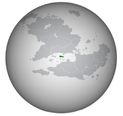
|map_caption = | |map_caption = Location of Bonaventura in the West Arucian Sea in green; Disputed territory of [[Dunhelm Island]] in red. | ||
|image_map2 = <!--Another map, if required--> | |image_map2 = <!--Another map, if required--> | ||
|alt_map2 = <!--alt text for second map--> | |alt_map2 = <!--alt text for second map--> | ||
| Line 26: | Line 26: | ||
|largest_settlement_type = <!--Type of settlement if largest settlement not a city--> | |largest_settlement_type = <!--Type of settlement if largest settlement not a city--> | ||
|official_languages = {{wpl|Italian language|Vespasian}} | |official_languages = {{wpl|Italian language|Vespasian}} | ||
|national_languages = [[Bonaventuran Creole]] | |national_languages = [[Bonaventuran Creole|Venturan]] | ||
|regional_languages = {{wp|Talian language|Astiveglian}}<br/>{{wp|Istriot language|Cariglian}} | |regional_languages = {{wp|Talian language|Astiveglian}}<br/>{{wp|Istriot language|Cariglian}}<br/>{{wp|Garifuna language|Mutuse}}<br/>{{wp|Taino language|Natí}} | ||
|languages_type = <!--Other type of languages --> | |languages_type = <!--Other type of languages --> | ||
|languages = <!--Other languages list--> | |languages = <!--Other languages list--> | ||
Revision as of 13:48, 27 March 2022
Bonaventurean Federation | |
|---|---|
 Location of Bonaventura in the West Arucian Sea in green; Disputed territory of Dunhelm Island in red. | |
| Capital and | Sermoni |
| Official languages | Vespasian |
| Recognised national languages | Venturan |
| Recognised regional languages | Astiveglian Cariglian Mutuse Natí |
| Demonym(s) | Bonaventurean |
| Government | Federative presidential republic |
• President | Vinicio Nardiello |
• Vice President | Liberio Ceci |
• President of National Assembly | Euseo Di Marino |
| Legislature | National Assembly |
| Formation | |
| Area | |
• | 40,015.36 km2 (15,450.02 sq mi) |
| Population | |
• 2020 estimate | 3,298 969 |
• Density | 82.44/km2 (213.5/sq mi) |
| HDI (2020) | 0.796 high |
| Currency | Arucian shilling (ſ) (ARS) |
| Date format | dd-mm-yyyy |
| Driving side | right |
| Calling code | +5 |
| ISO 3166 code | BON |
| Internet TLD | .bv |
Bonaventure (Vespasian: Bonaventura), also known as the Bonaventurean Federation (Vespasian: Federazione Bonaventurana) is a sovereign island nation located in the West Arucian sea, in between the continents of Asteria Superior and Asteria Inferior. Saint Cecilia has maritime borders with Ardesia to the north, Imagua and the Assimas to the south, Aucuria to the southeast, and Eldmark to the west. Saint Cecilia also holds the small island of Saint Clemente located a bit over 20km above the northern coast of the Imagua island. The capital and biggest city of Saint Cecilia is the city of Sermoni, located in the ???? coast of the island.

