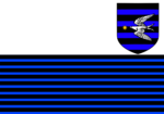
Ester (state)
Ester | |
|---|---|
| Crown State of Ester | |
| Nickname(s): "The Eastern sword of Leucen." | |
| Motto(s): "The hearts of men are imbued with the rage of the eastern seas." | |
 Location of Ester (red) on the map. | |
| Sovereign state | Chatten and Leucen |
| Nation | Leucen |
| Island | Leucen |
| Created by the Enabling Act of 1830 | 1 July 1830` |
| Capital | Inner Lambarinnon |
| Moothall | Sainchez Sourraterk |
| Largest city | Port Lambarinnon |
| Demonym(s) | Esterians |
| Leaders | |
• Governor | Nethania Fwynth |
| Turembel Calwyth | |
• House of Baronies representatives | 3 out of 76 representatives |
• Assembly of Commons representatives | 6 out of 188 representatives |
| Area | |
• Total | 20,203 km2 (7,800 sq mi) (16th) |
| Highest elevation | 1,443 m (4,734 ft) |
| Lowest elevation | 0 m (0 ft) |
| Population | |
• 2022 census | 3,412,556 (21st) |
• Density | 168.91/km2 (437.5/sq mi) (12th) |
| GDP (nominal) | 2022 estimate |
• Total | ₽52,008,567 (16th) |
• Per capita | ₽15,240.36 (21st) |
| HDI (2022) | very high · 19th |
| Currency | Leucish Piese (PIS) |
| Time zone | UTC+1 (NWT) |
| Calling code | +115 |
| ZIP_code | ES |
| ISO 3166 code | NK-ES |
| Internet TLD | .chl |
| Website | www.ester.gov.chl |
Ester, officially the Crown State of Ester, is a federal state situated in the eastern tip of the Porgynth Peninsula. It borders the Strait of Gorth, Gorth and the Bay of Porgynth to the north, Porgynth to the west, Maderynn Bay and Lacendynn Sea to the south, and the Eastern Sea to the east. With a population of 3.4 million, it is the 21st-most populated state and the 12th-densely populated. With an area of 20,203 km2 (7,800 sq mi), it is the 16th-largest state by area. As the easternmost state of Chatten and Leucen, it is a popular surfing destination amongst local and international tourists alike. The easternmost edge of the Porgynthian Range is situated here, with Mount Pocotus serving as its easternmost tip. Cape Gornom, the easternmost point of the country, is also located here. Its capital city, Inner Lambarinnon, is situated on the banks of the River Cwinson, in the county of Duran. The largest city is situated not far from the capital, with Port Lambarinnon serving as the state's premier entry harbor and economic hub. The state's main industries revolve around mining, fishing, and tourism; with tourism alone contributing to a quarter of its annual GDP. Its ports serve as an alternative entry point for trade and immigration arriving from the east.
History
Geography
Economy
Demographics
Culture
References
See also
- Demographics of Chatten and Leucen
- List of N.K states by Area
- List of N.K states by Human Development Index
- List of N.K states by net migration
- List of N.K states by nominal GDP
- List of N.K states by nominal GDP per capita
- List of N.K states by population
- List of N.K states by population density
- List of N.K states by ethnicity


