User:Glitter/EM
Miersan Socialist Federation Mierska federacja socjalistyczna | |
|---|---|
| Motto: "Nie ma wolności bez Solidarności" "There is no freedom without solidarity" | |
| Anthem: La Sobrosienne "The Zobrodzian" | |
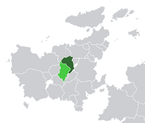
 Location of East Miersa (dark green) and claimed but uncontrolled territories (light green) in Euclea. | |
| Capital | Żobrodź |
| Government seat and largest city | Dynsk |
| Official languages | Miersan |
Recognised minority languages | |
| Ethnic groups (2016) | Miersan (61.6%) Kasavrine (5.4%) Savader (2.2%) Other (4.2%) No answer/no ethnic identity (26.6%) |
| Religion (2016) | Irreligious (64.2%) Catholicism (27.4%) Episemialism (1.8%) Other (6.6%) |
| Demonym(s) | East Miersan Miersan |
| Government | Federal socialist council republic |
| Iwo Kłosek | |
| Legislature | General Congress |
| Formation | |
| 13th century | |
| 17th century | |
| 5 March 1687 | |
| 17 January 1936 | |
• Current constitution | 21 October 1967 |
| Area | |
• Total | 197,568 km2 (76,281 sq mi) |
| Population | |
• 2017 estimate | 21,740,000 |
• Density | 110.04/km2 (285.0/sq mi) |
| GDP (nominal) | 2015 estimate |
• Total | $562.718 billion |
• Per capita | $25,884 |
| Currency | East Miersan grosz (MWG) |
| Time zone | UTC-1 |
| Internet TLD | .mw |
The Miersan Socialist Federation (Miersan: Mierska federacja socjalistyczna), also known as East Miersa (Miersan: Mierska Wschodnia), is a sovereign state in central Euclea, comprising the eastern portion of the historical nation of Miersa. It is bordered by Kantemosha and Kirenia to the north, by Aimilia and Gaullica to the east, and Champania and the breakaway state of Lemovicia to the south. To the west, it is bordered by West Miersa, though like its western counterpart, East Miersa claims to be the legitimate government of the entire Miersan nation. The country has an area of 197,568 km2 (76,281 sq mi) and a population of 21.7 million. According to the constitution, East Żobrodź is the capital, but this has limited international recognition.
