South Kabu
Jump to navigation
Jump to search
This article is incomplete because it is pending further input from participants, or it is a work-in-progress by one author. Please comment on this article's talk page to share your input, comments and questions. Note: To contribute to this article, you may need to seek help from the author(s) of this page. |
Socialist Republic of Kabu Republik Sosialis Wong Kabupik (Kabuese) | |
|---|---|
| Motto: Persatuan, Merdika, Podo, Buruh Unity, Freedom, Equality, Labour | |
| Anthem: Ing Internasionale | |
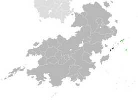
 Land controlled by South Kabu shown in dark green; land claimed but uncontrolled shown in light green. | |
| Capital and largest city | Ayukarta |
| Official languages | Kabuese |
| Recognised regional languages | Masiorese |
| Demonym(s) | Kabuese • North Kabuese |
| Government | Unitary Socialist Semi-Presidential Republic |
• President | Tirto Sutikno |
• Premier | Susilo Dwi |
| Legislature | People's Senate |
| Establishment | |
• Kabu Colony | 1797 |
• Treaty of TBD | 1947 |
• Negara Darurat | 1984 |
• Current Constitution | 1994 |
| Area | |
• | 44,154 km2 (17,048 sq mi) |
| Population | |
• 2018 census | 7,841,984 |
• Density | 178/km2 (461.0/sq mi) |
| GDP (PPP) | estimate |
• Total | $101.459 billion |
• Per capita | $12,938 |
| GDP (nominal) | 2019 estimate |
• Total | $45.271 billion |
• Per capita | $5,773 |
| Gini (2020) | 23.1 low |
| HDI (2020) | high |
| Driving side | right |
| Calling code | +62 |
| Internet TLD | .ku |
South Kabu (Kabuese: Kabupik Kidul), officially the Socialist Republic of Kabu (Kabuese: Republik Sosialis Wong Kabupik) is a country in Southeast Coius constituting the southern part of the Kabu Archipelago. The country shares a maritime border with North Kabu across the strait of TBD. Like it's Northern counterpart South Kabu claims the entirety of the Kabu Archipelago and the overseas territories of Kingsport and Nouvel Anglet of Estmere and Gaullica respectively.
The first human settlers arrived in what is now South Kabu at around 500AD. The earliest evidence of human settlements come from Yuwana.

