Dar Al Hamma
This article is incomplete because it is pending further input from participants, or it is a work-in-progress by one author. Please comment on this article's talk page to share your input, comments and questions. Note: To contribute to this article, you may need to seek help from the author(s) of this page. |
Dar Al Hamma
دار الحامة | |
|---|---|
| Dar Al Hamma | |
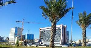
The Muntasir Economic District, in the southeastern suburbs of Dar Al Hamma. | |
| Nickname(s): الرائعة Ar Raii'ea The beautiful | |
 Location within Salamat | |
| Country | Salamat |
| Province | Dar Al Hamma (province) |
| Daira | Daira of Dar Al Hamma |
| Baladiya | Baladiyat of Dar Al Hamma |
| Capital | Dar Al Hamma |
| Government | |
| • Body | Baladiyat of Dar Al Hamma |
| • Mayor | Zakaria Bashari (Front for a Democratic and United Salamat) |
| Area | |
| • Total | 1,104.47 km2 (426.44 sq mi) |
| • Metro | 5,392.57 km2 (2,082.08 sq mi) |
| Elevation | 16 m (52 ft) |
| Population (2022) | |
| • Total | 3,128,935 |
| • Rank | 1st |
| • Metro | 5,720,324 |
| Demonym | Hammadi |
| Time zone | UTC-1 |
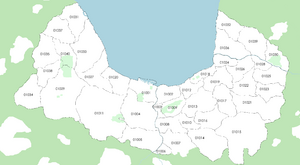
| Postal codes for Dar Al Hamma | 01001-01040 |
| Provincial code | +395-01 |
| Website | www |
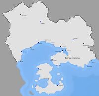
Dar Al Hamma (Arabic : دار الحامة) is the biggest and the most populous city of Salamat, and the capital of Salamat. Its population (surrounding cities included) is of 5,720,324 as of 2022. It is located in the Dar Al Hamma gulf, in eastern Salamat. The local geography includes hills, Oued Hamma, which crosses the city and a coastal plain, where most of the population is concentrated.
Geography
The geography of the region is marked by three elements ; The Jadhab-Hani plain, where most of the agriculture of Salamat as well as most of the suburbs of Dar Al Hamma are located (except the Casbah and the Bab Al Casabah districts located on a hill facing the sea), hills in the Hani Peninsula, as well as east and south of Dar Al Hamma whichs protects the city from dust and sand coming from the southeast, and the two major rivers of the city, the Oued Hamma and the Oued Frik. The mean elevation is of 16 meters, with the lowest point being the port of Dar Al Hamma at sea level and the highest area being the Mansur Hill, culminating at 185 meters above sea level.
Climate
The climate of Dar Al Hamma is a tropical savanna climate (Koppen : Aw). The box below is more detailed ;
| Climate data for Dar Al Hamma-Shahid Airport (1990–2020 averages) | |||||||||||||
|---|---|---|---|---|---|---|---|---|---|---|---|---|---|
| Month | Jan | Feb | Mar | Apr | May | Jun | Jul | Aug | Sep | Oct | Nov | Dec | Year |
| Record high °C (°F) | 39.8 (103.6) |
38.2 (100.8) |
38.7 (101.7) |
36.4 (97.5) |
35.2 (95.4) |
35.4 (95.7) |
35.2 (95.4) |
35.8 (96.4) |
36.1 (97.0) |
37.9 (100.2) |
38.8 (101.8) |
40.9 (105.6) |
40.9 (105.6) |
| Average high °C (°F) | 32.9 (91.2) |
32.4 (90.3) |
29.2 (84.6) |
26.9 (80.4) |
25.8 (78.4) |
25.3 (77.5) |
25.5 (77.9) |
26.2 (79.2) |
28.3 (82.9) |
29.7 (85.5) |
31.3 (88.3) |
32.0 (89.6) |
28.8 (83.8) |
| Daily mean °C (°F) | 30.5 (86.9) |
29.9 (85.8) |
27.1 (80.8) |
24.5 (76.1) |
23.8 (74.8) |
23.1 (73.6) |
22.7 (72.9) |
23.3 (73.9) |
26.6 (79.9) |
27.3 (81.1) |
28.8 (83.8) |
30.6 (87.1) |
26.5 (79.7) |
| Average low °C (°F) | 24.6 (76.3) |
23.9 (75.0) |
20.6 (69.1) |
18.3 (64.9) |
17.1 (62.8) |
16.5 (61.7) |
16.6 (61.9) |
17.4 (63.3) |
20.2 (68.4) |
22.5 (72.5) |
23.7 (74.7) |
24.5 (76.1) |
20.5 (68.9) |
| Record low °C (°F) | 14.3 (57.7) |
13.9 (57.0) |
11.2 (52.2) |
11.4 (52.5) |
9.8 (49.6) |
8.7 (47.7) |
8.4 (47.1) |
9.3 (48.7) |
10.2 (50.4) |
9.8 (49.6) |
10.5 (50.9) |
12.3 (54.1) |
8.4 (47.1) |
| Average precipitation mm (inches) | 7.4 (0.29) |
14.5 (0.57) |
19.2 (0.76) |
35.7 (1.41) |
56.2 (2.21) |
73.3 (2.89) |
142.9 (5.63) |
184.4 (7.26) |
203.8 (8.02) |
225.3 (8.87) |
12.6 (0.50) |
3.8 (0.15) |
979.1 (38.56) |
| Average precipitation days (≥ 1.0 mm) | 0 | 0 | 2 | 4 | 6 | 10 | 13 | 17 | 17 | 22 | 1 | 0 | 92 |
| Source: weathersalamat.com.sl | |||||||||||||
The climate of Dar Al Hamma is also marked by the winds from the southeast, which bring dust and sand from the desert in inner Thrismari, although being attenuated by the hills behind the city. These winds also lower the temperatures. During the night and during some periods of the year (early March, mid October), the winds blow from the north, bringing warm air and sometimes thunderstorms (especially in October).
Districts
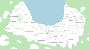
Dar Al Hamma has 40 districts. The most important districts are :
- Casbah, which hosts the old city of Dar Al Hamma. This district has a big historical value.
- Centre, which hosts most of the Riamese colonial architecture of the city and the Independence Square, the defined center of Dar Al Hamma. It also hosts the city hall.
- Bab Casbah, which has the Monument of the Martyrs and the Mansur Hill as symbols.
- El Khidj, which hosts the famous Jalal Ahmed Promenade.
- Muntasir, which acts as the economical district of Dar Al Hamma. It has the biggest concentration of skyscrapers in the city and it also hosts the Muntasir Commercial Center, the biggest of Salamat.
- Marsad, which hosts the Marsad Park and the Dar Al Hamma Observatory.
Transportation
Public transportation
Rail transportation
Air transportation
Monuments and other remarkable areas
Sports
Media
Television
Radio
Internet
Foreign embassies and consulates
Dar Al Hamma is home to TBA embassies and consulates. Here is the list of diplomatic buildings in the city ;
| Country | Address | Phone number | Ambassador |
|---|---|---|---|
| 29 Karim Boumhadi Street, Bab El Djamaa, Dar Al Hamma | (+395)-01-01-9482192 | Fatima Fawwaz | |
| 16 Fateh Street, Al Fathi, Dar Al Hamma | (+395)-01-01-3810463 | Ensarah Is | |
| 44 Malik Anwar Street, El Gamri, Dar Al Hamma (Before 1984 : 26 Diplomats Street, Al Fathi, Dar Al Hamma) | (+395)-01-01-2154526 | Marie Adlawan | |
| 52 Khadra Road, Al Fathi, Dar Al Hamma | Riamo : (+395)-01-01-2943027 Freice : (+395)-01-01-0119237 |
Riamo : TBA Freice : TBA | |
| 11 Diplomats Street, Al Fathi, Dar Al Hamma | (+395)-01-01-4931742 | Mauricio Torresani | |
| 258 Jalal Ahmed Promenade, El Khidj, Dar Al Hamma | (+395)-01-01-4984105 | Malivalaya Chearavanont |


