Kainuinoa
Council of Kainuinoa ʻAha o Kainuinoa 11 official names
| |||||||||||||||||||
|---|---|---|---|---|---|---|---|---|---|---|---|---|---|---|---|---|---|---|---|
|
Flag | |||||||||||||||||||
| Motto: ᨙ ᨊᨕᨗᨗ ᨓᨕᨒᨙ ᨊᨚ ᨚᨘᨀᨚᨘ᨞ ᨗ ᨀᨘᨘ ᨄᨚᨊᨚ ᨕᨚᨒᨙ ᨄᨕᨘ᨟ E naʻi wale nō ʻoukou, i kuʻu pono ʻaʻole pau "Prevail with my righteous deeds, for they are not yet finished." | |||||||||||||||||||
| Anthem: ᨖᨙ ᨆᨙᨒᨙ ᨒᨕᨖᨘᨗ ᨄᨚᨊᨚ He Mele Lāhui Pono "Song of the Righteous People" | |||||||||||||||||||
 Location of Kainuinoa on Earth. | |||||||||||||||||||
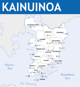
 Political Map of Kainuinoa | |||||||||||||||||||
| Capital | Wahiuliuli | ||||||||||||||||||
| Largest city | Johol | ||||||||||||||||||
| Official languages | Tokohanareo | ||||||||||||||||||
| Recognised regional languages | |||||||||||||||||||
| Ethnic groups (2020) | List of ethnicities | ||||||||||||||||||
| Religion | List of religions
| ||||||||||||||||||
| Demonym(s) | Kainuinoan Kainuinoans (plural) | ||||||||||||||||||
| Government | Federated Theocratic Noocratic Oligarchy | ||||||||||||||||||
• Guide of the Faithful | Kumu Ihupani | ||||||||||||||||||
| Legislature | National Consultative Assembly | ||||||||||||||||||
| Holy Council of the Righteous | |||||||||||||||||||
| Deliberative Council | |||||||||||||||||||
| Unification | |||||||||||||||||||
• Independence from Arthurista | November 13th, 1845 | ||||||||||||||||||
• Formation of the Holy Council | August 8th, 1852 | ||||||||||||||||||
• Safa'atoa Declaration | 1853 | ||||||||||||||||||
• Poi Reforms | April 28th, 1893 | ||||||||||||||||||
| Area | |||||||||||||||||||
• Total area | 134,864 km2 (52,071 sq mi) | ||||||||||||||||||
| Population | |||||||||||||||||||
• 2020 census | 38,000,000 | ||||||||||||||||||
• Density | [convert: invalid number] | ||||||||||||||||||
| GDP (nominal) | 2020 estimate | ||||||||||||||||||
• Total | $674,317,894,800 | ||||||||||||||||||
• Per capita | $15758 | ||||||||||||||||||
| Gini (2020) | low | ||||||||||||||||||
| HDI (2015) | very high | ||||||||||||||||||
| Currency | Kainuinoan Tālā (₮) | ||||||||||||||||||
| Time zone | UTC +6 | ||||||||||||||||||
| Date format | dd/mm/yyyy | ||||||||||||||||||
| Driving side | left | ||||||||||||||||||
| Calling code | +37 | ||||||||||||||||||
| Internet TLD | .kn | ||||||||||||||||||
Kainuinoa officially referred to as The Council of Kainuinoa is a Theocratic Noocracy in Southern Ochran between the Ozeros and Kayatman seas. It is bordered to the West by Ankat, to the North by Kiram, and shares a maritime border with Pulau Keramat to the South along the Monusiya strait. The majority of the nation's 38,215,500 people are concentrated on the mainland, while a sizeable portion live on one of the 215 islands and atolls scattered along the bay of Nihoa and southern tip of the mainland. The capital of Kainuinoa is Wahiuliuli, while the largest and most economically important cities are Johol, Faʻaʻā, and Panga. Kainuinoa is characterized by an ethnically diverse population, with Tokotahans groups composing a majority in the South while Lambaneh and Lambri are the largest of the many ethnic groups in the North.
Current archeological evidence suggests that the first archaic human settlers arrived at least 1.83 million years ago, while the earliest remnants of an anatomically modern humans in the region are roughly 40,000 years old. The ancestors of the present-day Lambaneh, Lambrinese, Halaeki, and Urangbuah entered in multiple waves in prehistorical and early historical times. The first kingdoms would rise during the Twin Dragons Period, in which the Lambaneh majority Kualambeh Kingdom would rise up in the East spreading North towards modern Kiram, while the Lambaneh/Halaeki majority Hanajala Empire consumed much of the Western coast up to the border of what is now modern Lusoña. A change in dynasty in the Hanajala Empire would transform it into what would become the regionally predominant Meuihmatan Empire, beginning the Age of Pearls. By 600 CE, the first waves of Tokotahan voyagers would begin to settle on the outer islands and, encouraged by the rising Tahamaja Empire, would begin to spread onto the mainland.
The rise of the Tahamaja would herald the beginning of Tokotahan dominance over the Kainuinoan peninsula and allow cities and settlements they had either founded or taken over to flourish under their rule. The eventual collapse of the Tahamaja Empire would affectively lead to the end of any peace in the region and, by the empires disestablishment in 1460 CE, would have broken into a loose series of alliances of warring city states and chiefdoms engaging in acts of piracy against each other. While a number of minor kingdoms and empires would attempt to vie for control over the peninsula, it was not until the arrival of the Mutulese in the 1600s that modern Kainuinoa would begin to shape into its modern borders. It was under the rule of the Mutulese that Tokotahan chiefs began to work more closely with the rulers of Lambaneh, allowing them to exert political and tapu religious authority further North and West. As the Mutulese global circuit began to crumble, by the 1800s Kainuinoa had solidified into the Royal Kainuinoan Federation encompassing the entirety of its modern borders. A brief period of Arthuristan dominionship over a number of ports, including the key trading port of Faʻaʻā and Ha'afeva led to the Revolution of the Righteous, leading to the removal of the Chiefs as the ruling class of the country, replacing it with the council of religious scholars that rules the nation up to the modern age. Contemporary Kainuinoan history is largely defined by indirect involvement in a variety of conflicts over the course of the 20th century, and direct involvement in the Hanaki War in the Lusoñan theater. Likewise, internal conflict with the indigenous Lambrinese has continued on and off over matters of sovereignty and self-determination.
In the modern era, Kainuinoa is a theocratic noocracy, with the ruling council of the country comprised primarily of religious scholars from the Tapu faith, with seats reserved for Azdarini ulama and N'nhivaran scholars as part of recent reforms. The deliberative council serves as an advisory council, composed of Chiefs and others Royalty, with public officials acting as advisors to the royalty. On an international scale, Kainuinoa is party to the Association of Ozeros Nations and Equatorial Trade Forum and maintains close diplomatic relations with all of its members. Tension with Pulau Keramat over the Monusian strait atolls is one of the defining modern issues facing the country.
Etymology
Demonyms
The internationally accepted Anglic demonym for Kainuinoa is Kainuinoan, but in local languages citizens are referred to as Parishioners (ex: Kahunapule, Auloto, Paroki), as a reference to the modern units of political land division in the country. In recent years, the term "neighbours" (ex: Hoalauna, Tuaoi, Leingka) has risen as a popular demonym used on social media among those who oppose or hope for reform to the national tapu system.
Official title
The name Kainuinoa is a compound word of Nihoan origins, meaning "coast of many names", an expression popularized by Tokotahan peoples during the Age of Pearls, a reference to the variety of ethnicities and languages present in the archipelago and on the islands. The Nihoan words Inoa meaning name, and nui translating roughly as large or many, were mixed in the early version of the name to avoid the double I. Variations of the name exist in other Tokotahan languages that have roughly the same meaning, including Teleigoa in Aleipata and Tokolahingoa in Tafahi, which take similar liberties to their Nihoan counterpart.
Other names are used interchangeably among other non-Tokotahan language groups, such as the Lambaney word Lambaneh, roughly translating to "of the quaint valley" for which the Lambaneh people take their name. The quaint valley referred to in the name is that which the city of Johol sits in, an area that has seen consistent habitation since antiquity. Other terms are also used, such as the Lambrinese word Kreung, which refers to the Hanajala name for the peninsula, named for the Kreung river that runs through central Lambri. The name, though traditional, retains a controversial history due to its association with the Lambrinese People's Liberation Front and Lambrinese nationalism.
Geography
Climate
Biodiversity
History
Prehistory & antiquity
Stone hand axes from early hominoids, probably Homo erectus, have been unearthed in Savusavu. They date back 1.83 million years, among the oldest pieces of evidence of hominid habitation in the Northern Ozeros.
The earliest evidence of modern human habitation in Kainuinoa is the 40,000-year-old skull excavated from the Ruhiruhia Caves in today's Faati. This is also one of the oldest modern human skulls in South Ochran. The first foragers visited the Ruhiruhia Caves 40,000 years ago when the first waves of proto-humans began to spread from Scipia into Ochran. Mesolithic and Neolithic burial sites have also been found in the area. The area around the Ruhiruhia Caves has been designated the Ruhiruhia Coast & Caves Sacred Grounds.
The oldest complete skeleton found in Kainuinoa is an 11,000-year-old Huahine man unearthed in 1991. The indigenous groups on the peninsula can be divided into four ethnicities: the Urangbuah, Halaeki, the Lambrinese, and the proto-Lambaneh. The first inhabitants of the Kainuinoan Peninsula were most probably the Lambrinese. These Mesolithic hunters were probably the ancestors of the Semang, an ethnic group that had spread north. The Halaeki appear to be a composite group, with approximately half of the maternal mitochondrial DNA lineages tracing back to the ancestors of the Lambrinese and about half to later ancestral migrations from other parts of the Ozeros. Scholars suggest they are descendants of early Ocrhanizeri-speaking agriculturalists, who brought both their language and their technology to the East of the peninsula approximately 4,000 years ago. They united and coalesced with the indigenous population. The Proto Lambaneh have a more diverse origin and had settled in Kainuinoa by 1000 BCE as a result of migration patterns from modern Yunxia. Although they show some connections with other inhabitants along the Ozeros, some also have an ancestry in the area surrounding Kainuinoa around the time of the Last Glacial Maximum about 20,000 years ago. Areas comprising what is now Kainuinoa participated in the Maritime [NETWORK NAME] Road. The trading network existed for 3,000 years, between 2000 BCE to 1000 CE. Anthropologists support the notion that the Proto-Lambaneh originated from what is today Yunxia. This was followed by an early-Holocene dispersal through the Kainuinoan Peninsula.
Age of Two Dragons
There were around 28 kingdoms under rule by the various ethnic groups of the Kainuinoan peninsula by 1000 BCE. The two largest: the Hanajala Kingdom (based in the port city of Binjai, now Faʻaʻā) and Kualambeh Kingdom (based in Lembah Bujang, 135 km from modern Puuwai) gradually began to consume their neighbors by way of war, intrigue, and marriage. Around 840 BCE, the Hanajala Kingdom stretched from the south end of the Kainuinoan peninsula along the Western coast up to the border with modern Lusoña; while the Kualambeh Kingdom stretched north to modern Kiram. Tensions mounted between the kingdoms, as the ruling Meurah P
Age of Pearls
-Meuihmatan Empire -Tokotahan Migrations -Tahamaja/Age of Pearls
Age of Fire and Sword
-Age of Fire -City States -Mutulese Global Circuit -Arthuristan Period
Manaʻolana ā paulele
-Assertion of Tokotahan cultural hegemony -Revolution of the Righteous -Hanaki War -Lambrinese seperatism
Modern history
-Strait conflicts with Pulau -Ozeros Community lore
Government & Politics
Law
Foreign Relations
Military
Constituencies
Economy
Agriculture
Energy
Tourism
Transportation
Science and Technology
Demographics
Ethnic Groups
Languages
Religions
Education
Health
Culture
Architecture
Cinema
Clothing
Cuisine
Holidays
Literature
Sport
Cite error: <ref> tags exist for a group named "lower-alpha", but no corresponding <references group="lower-alpha"/> tag was found

