Portal:Kylaris/Features: Difference between revisions
Jump to navigation
Jump to search
No edit summary |
No edit summary |
||
| (3 intermediate revisions by the same user not shown) | |||
| Line 1: | Line 1: | ||
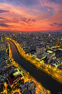
[[ | [[File:DJI_0196-HDR-Pano.jpg|right|thumb|200px|An evening view of a canalised tributary of the Buiganhingi as it flows through Naimhejia, the second biggest city in Dezevau]] | ||
''' | '''Urban planning in Dezevau''' is the planning and design of cities in [[Dezevau]]. It has a history that stretches back two thousand years or more, though modern urban planning only emerged after Dezevauni independence in 1941. It is a key academic, governmental and political concern, influenced strongly in the present day by the nature of local and federal power, and by the ideal of a democratic and socialist economy; its importance relates to the high level of urbanisation in Dezevau, which is about 70%. The most significant urban planning agencies are the district planning commissions, but like many other political processes in Dezevau, consultation with and input from both higher and lower governmental strata are crucial. | ||
('''[[Urban planning in Dezevau|See more...]]''') | |||
('''[[ | |||
<div style="text-align:right>[[File:KylarisRecognitionAchievement.png|25px]] '''{{cl|Kylaris Articles of Recognition|See all articles of recognition}}'''</div> | <div style="text-align:right>[[File:KylarisRecognitionAchievement.png|25px]] '''{{cl|Kylaris Articles of Recognition|See all articles of recognition}}'''</div> | ||
<div style="float:left;margin:0.5em 0.9em 0.4em 0;">{{Region icon Kylaris}}</div> | <div style="float:left;margin:0.5em 0.9em 0.4em 0;">{{Region icon Kylaris}}</div> | ||
Latest revision as of 23:38, 1 March 2024
Urban planning in Dezevau is the planning and design of cities in Dezevau. It has a history that stretches back two thousand years or more, though modern urban planning only emerged after Dezevauni independence in 1941. It is a key academic, governmental and political concern, influenced strongly in the present day by the nature of local and federal power, and by the ideal of a democratic and socialist economy; its importance relates to the high level of urbanisation in Dezevau, which is about 70%. The most significant urban planning agencies are the district planning commissions, but like many other political processes in Dezevau, consultation with and input from both higher and lower governmental strata are crucial. (See more...)
