Sermoni: Difference between revisions
| (41 intermediate revisions by 2 users not shown) | |||
| Line 1: | Line 1: | ||
[[Category:Bonaventura]]{{WIP}} | [[Category:Bonaventura]]{{WIP}} | ||
{{Infobox settlement | {{Infobox settlement | ||
|name = Sermoni | | name = Sermoni | ||
| | | official_name = <small>La Città dei Sermoni di Sant'Andrea dalla Baia</small> | ||
|native_name_lang = {{ | | native_name = | ||
|settlement_type = {{wpl|Municipality}} | | native_name_lang = <!-- ISO 639-1 code e.g. "fr" for French. If more than one, use {{lang}} instead --> | ||
| other_name = | |||
| settlement_type = {{wpl|Municipality}} | |||
<!-- transliteration(s) --> | |||
| translit_lang1 = | |||
| | | translit_lang1_type = | ||
| | | translit_lang1_info = | ||
| | | translit_lang1_type1 = | ||
| | | translit_lang1_info1 = | ||
| | | translit_lang1_type2 = | ||
| | | translit_lang1_info2 = <!-- etc., up to translit_lang1_type6 / translit_lang1_info6 --> | ||
| | | translit_lang2 = | ||
| | | translit_lang2_type = | ||
| | | translit_lang2_info = | ||
| | | translit_lang2_type1 = | ||
| | | translit_lang2_info1 = | ||
| | | translit_lang2_type2 = | ||
| | | translit_lang2_info2 = <!-- etc., up to translit_lang2_type6 / translit_lang2_info6 --> | ||
| | <!-- images, nickname, motto --> | ||
| image_skyline = {{multiple image | |||
| border = infobox | |||
| perrow = 1/2/1/2/1 | |||
| total_width = 280 | |||
| | | align = center | ||
| caption_align = center | |||
| image1 = Elevador-lacerda.jpeg | |||
| caption1 = The {{wp|Elevador Lacerda|Carella Elevator}} overlooking the Nautical Terminal of Sermoni | |||
| image2 = Pelourinho-salvador-bahia-brazil-venetia-featherstone-witty.jpeg | |||
| caption2 = {{wpl|Historic Center of Salvador|Uptown Sermoni}} | |||
| | | image3 = WhatsApp-Image-2023-04-10-at-19.31.51-1-1024x682.jpeg | ||
| | | caption3 = Lions' Palace | ||
| | | image4 = Image0klklkl.jpeg | ||
| | | caption4 = Bonaventura Avenue through Sermoni's Financial District | ||
| | | image5 = Amenities4.jpeg | ||
| | | caption5 = Coppie Beach, Porto Fortuna | ||
| | | image6 = Igreja-nossa-senhora-do-rosario-dos-pretos-2.png | ||
| caption6 = {{wpl|Church of Nossa Senhora do Rosário dos Pretos, Salvador|Church of Saint Andrew of the Bay}} | |||
| | |||
| | |||
| | |||
| | |||
| | |||
| | |||
| | |||
| | |||
| | |||
| | |||
| | |||
| | |||
}} | }} | ||
'''Sermoni''' ({{ | | imagesize = | ||
| image_alt = | |||
| image_caption = | |||
| image_flag = FlagBV04.png | |||
| flag_size = | |||
| flag_alt = | |||
| flag_border = | |||
| flag_link = | |||
| image_seal = | |||
| seal_size = | |||
| seal_alt = | |||
| seal_link = | |||
| seal_type = | |||
| image_shield = CoADFQB.png | |||
| shield_size = | |||
| shield_alt = | |||
| shield_link = | |||
| image_blank_emblem = CITTÀ DE (3).png | |||
| blank_emblem_type = Logo | |||
| blank_emblem_size = 53px | |||
| blank_emblem_alt = | |||
| blank_emblem_link = | |||
| etymology = | |||
| nickname = | |||
| nicknames = | |||
| motto = | |||
| mottoes = | |||
| anthem = | |||
<!-- maps and coordinates --> | |||
| image_map = | |||
| mapsize = | |||
| map_alt = | |||
| map_caption = | |||
| image_map1 = | |||
| mapsize1 = | |||
| map_alt1 = | |||
| map_caption1 = | |||
| pushpin_map = <!-- name of a location map as per Template:Location_map --> | |||
| pushpin_mapsize = | |||
| pushpin_map_alt = | |||
| pushpin_map_caption = | |||
| pushpin_map_caption_notsmall = | |||
| pushpin_label = <!-- only necessary if "name" or "official_name" are too long --> | |||
| pushpin_label_position = <!-- position of the pushpin label: left, right, top, bottom, none --> | |||
| pushpin_outside = | |||
| pushpin_relief = | |||
| pushpin_image = | |||
| pushpin_overlay = | |||
| coordinates = <!-- {{Coord}} --> | |||
| coor_pinpoint = <!-- to specify exact location of coordinates (was coor_type) --> | |||
| coordinates_footnotes = <!-- for references: use <ref> tags --> | |||
| grid_name = <!-- name of a regional grid system --> | |||
| grid_position = <!-- position on the regional grid system --> | |||
<!-- location --> | |||
| subdivision_type = Country | |||
| subdivision_name = {{flag|Bonaventura}} | |||
| subdivision_type1 = State | |||
| subdivision_name1 = {{flagicon image|FlagofSaintGiorgio.png}} San Giorgio | |||
| subdivision_type2 = | |||
| subdivision_name2 = <!-- etc., subdivision_type6 / subdivision_name6 --> | |||
<!-- established --> | |||
| established_title = Founded | |||
| established_date = 4 January 1538 | |||
| established_title1 = <!-- Incorporated (town) --> | |||
| established_date1 = <!-- requires established_title1= --> | |||
| established_title2 = <!-- Incorporated (city) --> | |||
| established_date2 = <!-- requires established_title2= --> | |||
| established_title3 = | |||
| established_date3 = <!-- requires established_title3= --> | |||
| established_title4 = | |||
| established_date4 = <!-- requires established_title4= --> | |||
| established_title5 = | |||
| established_date5 = <!-- requires established_title5= --> | |||
| established_title6 = | |||
| established_date6 = <!-- requires established_title6= --> | |||
| established_title7 = | |||
| established_date7 = <!-- requires established_title7= --> | |||
| extinct_title = | |||
| extinct_date = | |||
| founder = | |||
| named_for = | |||
<!-- seat, smaller parts --> | |||
| seat_type = | |||
| seat = | |||
| seat1_type = <!-- defaults to: Former seat --> | |||
| seat1 = | |||
| parts_type = Municipal {{wpl|Circoscrizione|Circoscrizioni}}: | |||
| parts_style = coll | |||
| parts = 7 | |||
| p1 = La Chiesa | |||
| p2 = Porto Fortuna | |||
| p3 = Le Donne | |||
| p4 = Borghesi | |||
| p5 = San Genaro | |||
| p6 = Piazza Ottobre | |||
| p7 = Laguardia—Candela | |||
<!-- government type, leaders --> | |||
| government_footnotes = <!-- for references: use <ref> tags --> | |||
| government_type = | |||
| governing_body = | |||
| leader_party = | |||
| leader_title = {{wpl|Mayor}} | |||
| leader_name = Gaspare Garofano | |||
| leader_title1 = | |||
| leader_name1 = <!-- etc., up to leader_title4 / leader_name4 --> | |||
<!-- display settings --> | |||
| total_type = <!-- to set a non-standard label for total area and population rows --> | |||
| unit_pref = metric | |||
<!-- area --> | |||
| area_footnotes = <!-- for references: use <ref> tags --> | |||
| dunam_link = <!-- If dunams are used, this specifies which dunam to link. --> | |||
| area_total_km2 = 303.38 | |||
| area_total_sq_mi = <!-- see table @ Template:Infobox settlement for details --> | |||
| area_total_ha = | |||
| area_total_acre = | |||
| area_total_dunam = <!-- used in Middle East articles only --> | |||
| area_land_km2 = | |||
| area_land_sq_mi = | |||
| area_land_ha = | |||
| area_land_acre = | |||
| area_land_dunam = <!-- used in Middle East articles only --> | |||
| area_water_km2 = | |||
| area_water_sq_mi = | |||
| area_water_ha = | |||
| area_water_acre = | |||
| area_water_dunam = <!-- used in Middle East articles only --> | |||
| area_water_percent = | |||
| area_urban_footnotes = <!-- for references: use <ref> tags --> | |||
| area_urban_km2 = | |||
| area_urban_sq_mi = | |||
| area_urban_ha = | |||
| area_urban_acre = | |||
| area_urban_dunam = <!-- used in Middle East articles only --> | |||
| area_rural_footnotes = <!-- for references: use <ref> tags --> | |||
| area_rural_km2 = | |||
| area_rural_sq_mi = | |||
| area_rural_ha = | |||
| area_rural_acre = | |||
| area_rural_dunam = <!-- used in Middle East articles only --> | |||
| area_metro_footnotes = <!-- for references: use <ref> tags --> | |||
| area_metro_km2 = 2204.26 | |||
| area_metro_sq_mi = | |||
| area_metro_ha = | |||
| area_metro_acre = | |||
| area_metro_dunam = <!-- used in Middle East articles only --> | |||
| area_rank = | |||
| area_blank1_title = | |||
| area_blank1_km2 = | |||
| area_blank1_sq_mi = | |||
| area_blank1_ha = | |||
| area_blank1_acre = | |||
| area_blank1_dunam = <!-- used in Middle East articles only --> | |||
| area_blank2_title = | |||
| area_blank2_km2 = | |||
| area_blank2_sq_mi = | |||
| area_blank2_ha = | |||
| area_blank2_acre = | |||
| area_blank2_dunam = <!-- used in Middle East articles only --> | |||
| area_note = | |||
<!-- dimensions --> | |||
| dimensions_footnotes = <!-- for references: use <ref> tags --> | |||
| length_km = | |||
| length_mi = | |||
| width_km = | |||
| width_mi = | |||
<!-- elevation --> | |||
| elevation_footnotes = <!-- for references: use <ref> tags --> | |||
| elevation_m = | |||
| elevation_ft = | |||
| elevation_point = <!-- for denoting the measurement point --> | |||
| elevation_max_footnotes = <!-- for references: use <ref> tags --> | |||
| elevation_max_m = | |||
| elevation_max_ft = | |||
| elevation_max_point = <!-- for denoting the measurement point --> | |||
| elevation_max_rank = | |||
| elevation_min_footnotes = <!-- for references: use <ref> tags --> | |||
| elevation_min_m = | |||
| elevation_min_ft = | |||
| elevation_min_point = <!-- for denoting the measurement point --> | |||
| elevation_min_rank = | |||
<!-- population --> | |||
| population_footnotes = <!-- for references: use <ref> tags --> | |||
| population_as_of = 2022 | |||
| population_total = 322872 | |||
| pop_est_footnotes = | |||
| pop_est_as_of = | |||
| population_est = | |||
| population_rank = 1st | |||
| population_density_km2 = <!-- for automatic calculation of any density field, use: auto --> | |||
| population_density_sq_mi = | |||
| population_urban_footnotes = | |||
| population_urban = | |||
| population_density_urban_km2 = | |||
| population_density_urban_sq_mi = | |||
| population_rural_footnotes = | |||
| population_rural = | |||
| population_density_rural_km2 = | |||
| population_density_rural_sq_mi = | |||
| population_metro_footnotes = | |||
| population_metro = 1012722 | |||
| population_density_metro_km2 = | |||
| population_density_metro_sq_mi = | |||
| population_density_rank = | |||
| population_blank1_title = | |||
| population_blank1 = | |||
| population_density_blank1_km2 = | |||
| population_density_blank1_sq_mi = | |||
| population_blank2_title = | |||
| population_blank2 = | |||
| population_density_blank2_km2 = | |||
| population_density_blank2_sq_mi = | |||
| population_demonym = Sermoninian | |||
| population_demonyms = | |||
| population_note = | |||
<!-- demographics (section 1) --> | |||
| demographics_type1 = | |||
| demographics1_footnotes = <!-- for references: use <ref> tags --> | |||
| demographics1_title1 = | |||
| demographics1_info1 = <!-- etc., up to demographics1_title7 / demographics1_info7 --> | |||
<!-- demographics (section 2) --> | |||
| demographics_type2 = | |||
| demographics2_footnotes = <!-- for references: use <ref> tags --> | |||
| demographics2_title1 = | |||
| demographics2_info1 = <!-- etc., up to demographics2_title10 / demographics2_info10 --> | |||
<!-- time zone(s) --> | |||
| timezone_link = | |||
| timezone1_location = | |||
| timezone1 = West Arucian Time | |||
| utc_offset1 = +11 | |||
| timezone1_DST = | |||
| utc_offset1_DST = | |||
| timezone2_location = | |||
| timezone2 = | |||
| utc_offset2 = | |||
| timezone2_DST = | |||
| utc_offset2_DST = | |||
| timezone3_location = | |||
| timezone3 = | |||
| utc_offset3 = | |||
| timezone3_DST = | |||
| utc_offset3_DST = | |||
| timezone4_location = | |||
| timezone4 = | |||
| utc_offset4 = | |||
| timezone4_DST = | |||
| utc_offset4_DST = | |||
| timezone5_location = | |||
| timezone5 = | |||
| utc_offset5 = | |||
| timezone5_DST = | |||
| utc_offset5_DST = | |||
<!-- postal codes, area code --> | |||
| postal_code_type = <!-- enter ZIP Code, Postcode, Post code, Postal code... --> | |||
| postal_code = | |||
| postal2_code_type = <!-- enter ZIP Code, Postcode, Post code, Postal code... --> | |||
| postal2_code = | |||
| area_code_type = <!-- defaults to: Area code(s) --> | |||
| area_code = +5 11 | |||
| area_codes = | |||
| geocode = | |||
| iso_code = | |||
| registration_plate_type = | |||
| registration_plate = | |||
| code1_name = | |||
| code1_info = | |||
| code2_name = | |||
| code2_info = | |||
<!-- blank fields (section 1) --> | |||
| blank_name_sec1 = | |||
| blank_info_sec1 = | |||
| blank1_name_sec1 = | |||
| blank1_info_sec1 = | |||
| blank2_name_sec1 = | |||
| blank2_info_sec1 = <!-- etc., up to blank7_name_sec1 / blank7_info_sec1 --> | |||
<!-- blank fields (section 2) --> | |||
| blank_name_sec2 = | |||
| blank_info_sec2 = | |||
| blank1_name_sec2 = | |||
| blank1_info_sec2 = | |||
| blank2_name_sec2 = | |||
| blank2_info_sec2 = <!-- etc., up to blank7_name_sec2 / blank7_info_sec2 --> | |||
<!-- website, footnotes --> | |||
| website = <!-- {{URL|example.com}} --> | |||
| module = | |||
| footnotes = | |||
}} | |||
'''Sermoni''' ({{wp|Help:IPA/English|/sɜːr'mɒni/}}, {{wp|Italian language|Vespasian}}: ''Sermoni'' {{wp|Help:IPA/Italian|/serˈmo.ni/}}), shortened version of '''La Città dei Sermoni di Sant'Andrea dalla Baia''', and sometimes referred to as '''Saint Andrew''' ({{wpl|Italian language|Vespasian}}: ''Sant'Andrea''), is the {{wpl|capital city|capital}} and largest city of [[Bonaventura]]. The city is located on the southern bank of the [[Maruchei River]] delta by the [[Womens' bay]], in the southern coast of the island. Sermoni is not only the most populated city in Bonaventura, with a population of over 320 thousand people, but also the 3rd most populated in the [[West Arucian]], behind [[Porte de la Sainte]] and [[Tranquille]], both located in [[Sainte-Chloé]]. Sermoni is also the biggest city in the Sermoni—Riga {{wpl|metropolitan area}}, the largest urban conglomerate in Bonaventura. | |||
In 1531, a religious mission led by Priest [[Fosco Barba]] saw the establishment and construction of the Saint Andrew’s Parish and the Church of Saint Andrew of the Bay over nowadays Uptown Sermoni. Following the Etrurian victory in the [[Fragmentation war (Bonaventura)|Fragmentation war]] and the arrival of the [[Etruria#constituent states|Accadian]] Families in the port of the Parish of Saint Andrew, the colony of [[New Accadia]] was settled and the Parish had been officially elevated to a village by January 1538. The city that initially was called Saint Andrew of the Bay quickly received the nickname of “the city of sermons,” given the importance and the fervous participation of the local religious community. | |||
The city quickly grew in population, as most of the inhabitants of the then colonial capital city of [[Riga]], which was being constantly raid by pirates. The position of Saint Andrew and the water route necessary to reach it were both strategic and defensively convenient to the New Accadian government. By 1704, Saint Andrew not only officially changed its name to the ''City of Saint Andrew's Sermons'', but also officially became the seat of the colonial administration. However, in 1804, a {{wpl|Richter scale|category 7}} {{wpl|earthquake}} hit the [[Iacattuotili Valley]] and it nearly destroyed Sermoni. After almost a decade of reconstruction, the city restablished itself and it has, since then, exponentially grown in area, population, and riches. | |||
Sermoni is a modern economical and social hub not only in Bonaventura, but also in the Arucian. It often tops regional lists in topics such as {{wpl|education}}, {{wpl|health}}, {{wpl|infrestucture}}, {{wpl|entrepeneurship}}, and {{wpl|quality of life}}. Sermoni is the most diverse and economically developed city in Bonaventura, being consistantely ranked as a [[World City Studies Institute|third-rate]] [[World City Studies Institute|world city]] by the [[World City Studies Institute]]. The city is a pivotal regional center in technology, business, social and urban development, housing some of the best Arucian universities, such as the [[Federal University of Saint Andrew]], the [[Laguna University]], and the [[Scientific Institute of Bonaventura]]. | |||
==History== | |||
==Geography== | |||
==Administration== | |||
===City Government=== | |||
According to the [[Bonaventura#History|Bonaventuran constitution of 1956]], Sermoni is a recognized {{wpl|municipality}} within the [[State of San Giorgio (Bonaventura)|State of San Giorgio]] and an integral part of the [[Bonaventura#Sub-divisions|Bonaventuran federation system]]. As a municipality, Sermoni’s executive branch is governed by a {{wpl|Mayor}} (''Sindaco''), currently Gaspare Garofano, and its legislative branch by a {{wpl|Unicameralism|unicameral}} Municipal Assembly (''Assemblaggio Comunale''), all of which are popularly elected every four years. Though Sermoni is responsible for its constitution and laws, it holds no {{wpl|Judiciary|judicial power}}, with which are the responsibility of the State and/or the Federation to maintain. The municipality is free to set and collect {{wpl|property taxes}}, {{wpl|income taxes}}, and {{wpl|corporate income taxes}}. | |||
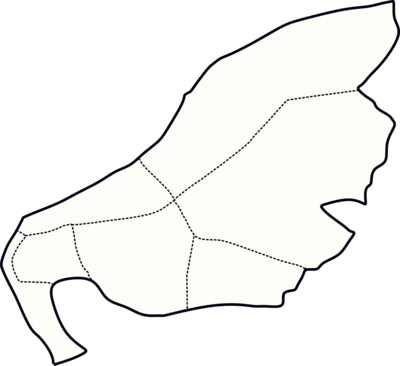
While normally the seat of a municipality is the local {{wpl|city}} (''Città''), Sermoni, as a municipality populated by more than 100,000 people, is further subdivided into ''{{wpl|Circoscrizione|circoscrizioni}}'' (similar to the “{{wpl|arrondissement|arrondissements}}” in [[Verlois]]). Each circoscrizione is administrated by a Council (''Consiglio di Circoscrizione''), whose representatives are popularly elected every four years. The Sermoni city hall, also known as the Palace on the Hill, is located in the ''Prima Circoscizioni'', also known as La Chiesa (or Uptown Sermoni). In total, Sermoni is subdivided into 7 ''circoscrizioni'': La Chiesa, Porto Fortuna, Le Donne, Borghesi, San Genaro, Piazza Ottobre, and Laguardia—Candela. Each Sermoninian ''circoscrizioni'' is further divided into Quarters (''{{wpl|Quartiere|Quartieri}}''), thus configuring Sermoni as the only municipality in Bonaventura that is not further divided into Thirds (''{{wpl|Terziere|Terzieri}}''). | |||
{| class="wikitable sortable" style="margin-left: auto; margin-right: auto; border: none;text-align: center;" | |||
| rowspan="8" |{{Template:Sermoni labelled map}} | |||
! Emblem !! Circ. !! Name !! Population | |||
|- | |||
| [[File:Blason ville fr Saint-Sulpice-la-Forêt 35.svg|35px]] || I || La Chiesa || ???? | |||
|- | |||
| [[File:Blason ville fr Chisseaux (Indre-et-Loire).svg|35px]] || II || Porto Fortuna || ???? | |||
|- | |||
| [[File:Blason Maisons 14.svg|35px]] || III || Le Donne || ???? | |||
|- | |||
| [[File:Arms of McDonnell of Antrim.svg|35px]] || IV || Borghesi || ???? | |||
|- | |||
| [[File:Arborea coat-of-arms.svg|35px]] || V || San Genaro || ???? | |||
|- | |||
| [[File:Blason famille bzh Abraham.svg|35px]] || VI || Piazza Ottobre || ???? | |||
|- | |||
| [[File:Blason ville fr Saint-Prancher (Vosges).svg|35px]] || VII || Laguardia—Candela || ???? | |||
|- | |||
|} | |||
===Metro Sermoni=== | |||
[[image:SermoniBORDERS copy.png|thumb|350px|right|Map of the municipalities consisting of the Sermoni Metropolitan Area.]] | |||
===National Government=== | |||
==Economy== | |||
==Urban Infrestucture== | |||
==Transportation== | |||
==Demographics== | |||
==Culture== | |||
===Music=== | |||
===Literature=== | |||
===Theatres=== | |||
===Sports=== | |||
While the [[State of San Giorgio (Bonaventura)|State of San Giorgio]] is historically and culturally an "{{wpl|association football}} state," Sermoni’s biggest fan base lies in {{wpl|Baseball}}. The two local teams (the [[Sermoni Fortunates]] and the [[Sermoni Krakens]]) are both historical and modern powerhouses of the [[Arucian Baseball League]], with the Krakens being its current champions. Sermoni also has a solid presence in the Bonaventuran league of association football ([[Bonaventura Serie A]]), with its local representatives, the X and the X, being two out of three teams that have never been relegated in the league’s history. Sermoni is, however, the city with the biggest amount of teams participating in [[The Bonaventuran Championship|The Bonaventuran Championship of Arucian Football (Venturone)]]; there are six in total: [[La Armada FA]], [[Internazionale Sermoni FA]], [[Piazza Ottobre FA]], [[SS San Genaro]], [[SFA Sermoni Krakens]], and the [[Società Sermonina di FA]]. | |||
Sermoni’s sportive infrastructure is the most advanced in Bonaventura. While [[Sermoni Fortunates|Campo Fortunato]] is the biggest and most traditional baseball stadium in Bonaventura, the [[Sermoni Krakens|BB Arena]] is amongst the most modern {{wpl|ballpark|ballparks}} in the ABL. The ''Stadio Nazionale'', co-owned by both X and the X, is the biggest association football stadium in the Arucian, and the home of the [[Bonaventuran National Football Team]]. There are 5 major Arucian football stadiums in Sermoni, with only the ''Stadio Comunale Giacomo Borghesi'' being co-owned by both Inter Sermoni and the SSFA. Sermoni houses the [[Polisportiva Adriana Baranello]], the biggest {{wpl|sports complex}} in Bonaventura, and one of the biggest in the Arucian. The Polisportiva accounts for {{wpl|tennis courts}}, as well as {{wpl|olympic pools|Invictus swimming pools}}, {{wpl|basketball courts|basketball}}, {{wpl|volleyball court|volleyball}} and {{wpl|Indoor Football court|indoor football courts}}; {{wpl|gymnasium|gymnasiums}}, and {{wpl|running tracks}} (with and without {{wpl|obstacle racing|obstacles}}). The Baranello center is considered to be the heart of the Bonaventuran Invictus sportspeople, being where most of them go to train and compete and often refferd to as the ''"Invictus City."'' | |||
==Sister Cities== | ==Sister Cities== | ||
Sermoni is {{wp|Sister city|twinned}} or cooperating with several cities, some of which include : | Sermoni is {{wp|Sister city|twinned}} or cooperating with several cities, some of which include : | ||
* {{flagicon|Île d'Émeraude}} [[Port-au-Grégoire]], [[Île d'Émeraude]] | |||
* {{flagicon|Imagua and the Assimas}} [[Cuanstad]], [[Imagua and the Assimas]] | * {{flagicon|Imagua and the Assimas}} [[Cuanstad]], [[Imagua and the Assimas]] | ||
* {{flagicon|Satavia}} [[Henschhoek]], [[Satavia]] | |||
* {{flagicon|Puramape}} [[Saint Ferdinand de la Vallée de la Providence|Providence]], [[Puramape]] | * {{flagicon|Puramape}} [[Saint Ferdinand de la Vallée de la Providence|Providence]], [[Puramape]] | ||
Latest revision as of 14:22, 3 October 2023
This article is incomplete because it is pending further input from participants, or it is a work-in-progress by one author. Please comment on this article's talk page to share your input, comments and questions. Note: To contribute to this article, you may need to seek help from the author(s) of this page. |
Sermoni | |
|---|---|
| La Città dei Sermoni di Sant'Andrea dalla Baia | |
The Carella Elevator overlooking the Nautical Terminal of Sermoni Lions' Palace Bonaventura Avenue through Sermoni's Financial District Coppie Beach, Porto Fortuna | |
 Flag  Coat of arms .png) Logo | |
| Country | |
| State | |
| Founded | 4 January 1538 |
| Municipal Circoscrizioni: | List
|
| Government | |
| • Mayor | Gaspare Garofano |
| Area | |
| • Municipality | 303.38 km2 (117.14 sq mi) |
| • Metro | 2,204.26 km2 (851.07 sq mi) |
| Population (2022) | |
| • Municipality | 322,872 |
| • Rank | 1st |
| • Metro | 1,012,722 |
| Demonym | Sermoninian |
| Time zone | UTC+11 (West Arucian Time) |
| Area code | +5 11 |


Sermoni (/sɜːr'mɒni/, Vespasian: Sermoni /serˈmo.ni/), shortened version of La Città dei Sermoni di Sant'Andrea dalla Baia, and sometimes referred to as Saint Andrew (Vespasian: Sant'Andrea), is the capital and largest city of Bonaventura. The city is located on the southern bank of the Maruchei River delta by the Womens' bay, in the southern coast of the island. Sermoni is not only the most populated city in Bonaventura, with a population of over 320 thousand people, but also the 3rd most populated in the West Arucian, behind Porte de la Sainte and Tranquille, both located in Sainte-Chloé. Sermoni is also the biggest city in the Sermoni—Riga metropolitan area, the largest urban conglomerate in Bonaventura.
In 1531, a religious mission led by Priest Fosco Barba saw the establishment and construction of the Saint Andrew’s Parish and the Church of Saint Andrew of the Bay over nowadays Uptown Sermoni. Following the Etrurian victory in the Fragmentation war and the arrival of the Accadian Families in the port of the Parish of Saint Andrew, the colony of New Accadia was settled and the Parish had been officially elevated to a village by January 1538. The city that initially was called Saint Andrew of the Bay quickly received the nickname of “the city of sermons,” given the importance and the fervous participation of the local religious community.
The city quickly grew in population, as most of the inhabitants of the then colonial capital city of Riga, which was being constantly raid by pirates. The position of Saint Andrew and the water route necessary to reach it were both strategic and defensively convenient to the New Accadian government. By 1704, Saint Andrew not only officially changed its name to the City of Saint Andrew's Sermons, but also officially became the seat of the colonial administration. However, in 1804, a category 7 earthquake hit the Iacattuotili Valley and it nearly destroyed Sermoni. After almost a decade of reconstruction, the city restablished itself and it has, since then, exponentially grown in area, population, and riches.
Sermoni is a modern economical and social hub not only in Bonaventura, but also in the Arucian. It often tops regional lists in topics such as education, health, infrestucture, entrepeneurship, and quality of life. Sermoni is the most diverse and economically developed city in Bonaventura, being consistantely ranked as a third-rate world city by the World City Studies Institute. The city is a pivotal regional center in technology, business, social and urban development, housing some of the best Arucian universities, such as the Federal University of Saint Andrew, the Laguna University, and the Scientific Institute of Bonaventura.
History
Geography
Administration
City Government
According to the Bonaventuran constitution of 1956, Sermoni is a recognized municipality within the State of San Giorgio and an integral part of the Bonaventuran federation system. As a municipality, Sermoni’s executive branch is governed by a Mayor (Sindaco), currently Gaspare Garofano, and its legislative branch by a unicameral Municipal Assembly (Assemblaggio Comunale), all of which are popularly elected every four years. Though Sermoni is responsible for its constitution and laws, it holds no judicial power, with which are the responsibility of the State and/or the Federation to maintain. The municipality is free to set and collect property taxes, income taxes, and corporate income taxes.
While normally the seat of a municipality is the local city (Città), Sermoni, as a municipality populated by more than 100,000 people, is further subdivided into circoscrizioni (similar to the “arrondissements” in Verlois). Each circoscrizione is administrated by a Council (Consiglio di Circoscrizione), whose representatives are popularly elected every four years. The Sermoni city hall, also known as the Palace on the Hill, is located in the Prima Circoscizioni, also known as La Chiesa (or Uptown Sermoni). In total, Sermoni is subdivided into 7 circoscrizioni: La Chiesa, Porto Fortuna, Le Donne, Borghesi, San Genaro, Piazza Ottobre, and Laguardia—Candela. Each Sermoninian circoscrizioni is further divided into Quarters (Quartieri), thus configuring Sermoni as the only municipality in Bonaventura that is not further divided into Thirds (Terzieri).
I
II
III
IV
V
VI
VII
|
Emblem | Circ. | Name | Population |
|---|---|---|---|---|
| I | La Chiesa | ???? | ||
| II | Porto Fortuna | ???? | ||
| III | Le Donne | ???? | ||
| IV | Borghesi | ???? | ||
| V | San Genaro | ???? | ||
| VI | Piazza Ottobre | ???? | ||
| VII | Laguardia—Candela | ???? |
Metro Sermoni

National Government
Economy
Urban Infrestucture
Transportation
Demographics
Culture
Music
Literature
Theatres
Sports
While the State of San Giorgio is historically and culturally an "association football state," Sermoni’s biggest fan base lies in Baseball. The two local teams (the Sermoni Fortunates and the Sermoni Krakens) are both historical and modern powerhouses of the Arucian Baseball League, with the Krakens being its current champions. Sermoni also has a solid presence in the Bonaventuran league of association football (Bonaventura Serie A), with its local representatives, the X and the X, being two out of three teams that have never been relegated in the league’s history. Sermoni is, however, the city with the biggest amount of teams participating in The Bonaventuran Championship of Arucian Football (Venturone); there are six in total: La Armada FA, Internazionale Sermoni FA, Piazza Ottobre FA, SS San Genaro, SFA Sermoni Krakens, and the Società Sermonina di FA.
Sermoni’s sportive infrastructure is the most advanced in Bonaventura. While Campo Fortunato is the biggest and most traditional baseball stadium in Bonaventura, the BB Arena is amongst the most modern ballparks in the ABL. The Stadio Nazionale, co-owned by both X and the X, is the biggest association football stadium in the Arucian, and the home of the Bonaventuran National Football Team. There are 5 major Arucian football stadiums in Sermoni, with only the Stadio Comunale Giacomo Borghesi being co-owned by both Inter Sermoni and the SSFA. Sermoni houses the Polisportiva Adriana Baranello, the biggest sports complex in Bonaventura, and one of the biggest in the Arucian. The Polisportiva accounts for tennis courts, as well as Invictus swimming pools, basketball, volleyball and indoor football courts; gymnasiums, and running tracks (with and without obstacles). The Baranello center is considered to be the heart of the Bonaventuran Invictus sportspeople, being where most of them go to train and compete and often refferd to as the "Invictus City."
Sister Cities
Sermoni is twinned or cooperating with several cities, some of which include :