File:Orinese colonial empire.png
Jump to navigation
Jump to search

Size of this preview: 800 × 573 pixels. Other resolution: 1,523 × 1,091 pixels.
Original file (1,523 × 1,091 pixels, file size: 65 KB, MIME type: image/png)
Summary
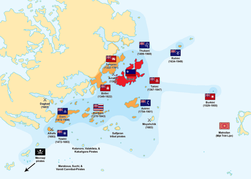
All territories that were ever part of the Orinese colonial empire, 14th century-20th century.
Core empire
Colonial presence
Temporary presence
Sea under Orinese influence
Extent of Orinese naval expeditions
File history
Click on a date/time to view the file as it appeared at that time.
| Date/Time | Thumbnail | Dimensions | User | Comment | |
|---|---|---|---|---|---|
| current | 10:36, 1 February 2022 | | 1,523 × 1,091 (65 KB) | Orioni (talk | contribs) | |
| 14:06, 7 October 2021 |  | 1,403 × 858 (51 KB) | Orioni (talk | contribs) | ||
| 17:18, 19 November 2019 |  | 515 × 475 (5 KB) | Orioni (talk | contribs) | Category:Orioni Category:Maps Category:Europa Category:Eurth |
You cannot overwrite this file.
File usage
The following 4 pages use this file: