List of counties in Angland
This article is incomplete because it is pending further input from participants, or it is a work-in-progress by one author. Please comment on this article's talk page to share your input, comments and questions. Note: To contribute to this article, you may need to seek help from the author(s) of this page. |
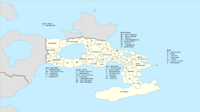
The counties of Angland are areas used for different purposes, which include administrative, geographical, cultural and political demarcation. The term "county" is defined in several ways and can apply to similar or the same areas used by each of these demarcation structures. These different types of county each have a more formal name but are commonly referred to as just "counties". The current arrangement is the result of incremental reform.
The original county structure originates from the middle ages, under the reign of King Richard II. These counties are commonly reffered to as the historic counties of Angland.
List of Counties
Greater Retoria
Greater Retoria is an administrative area in Angland governed by the Greater Retoria City Council. It is organised into 33 local government districts: the 32 Retoria boroughs and the City of Retoria. Greater Retoria is one of the regions of Angland, also known as the Retoria Metripolitan Region. The Greater Retoria City Council, based in Neaton as of the start of 2022, is responsible for strategic local government across the area and consists of the Mayor of Retoria and the Retoria Assembly.
Cornkien
Cornkien (/ˌkˈɔː͡ɹŋki͡ən/; Cornkien: Kernkiew [kˈɜːŋkjuː]) is a historic county and ceremonial county in South East Angland. It is recognised as one of the Celtic nations, and is the homeland of the Cornkien people. For this reason Cornkien is also recognised as an autonomous community and has more autonomy than a majority of other counties. It is also by far the largest Anglish county, taking up the entire Cornkien peninsula. Cornkien is bordered to the north and east by the Merillian Ocean, to the south by the Aurean Sea, and to the north by the county of St.John, with the River Kumare forming the border between them. It contains the southern most point of metripolitan Angland, at Land's End. The administrative centre of Cornkien is Keverne, its only city.
Leamingshire
Leamingshire is a county in the north midlands region of Angland. It borders Greater Retoria, Ledecestershire, Snottinghamshire, Anaham, North Handings, North Tidings, Cestershire, Matthewston and Abershire. It is the biggest non-autonomous county in the country and is home to a large amount of historic fortifications due to it's position to the capital. The county city is Westhampton, the fourth largest city in the country. The ceremonial county capital, however, is Leaming, a small town in the center of the county. It is a popular destination for international and domestic tourists to explore both medieval and more recent history.
Cestershire
Newfort
County Baths
Keelshire
References
See Also
- Angland


