Volain
This article is incomplete because it is pending further input from participants, or it is a work-in-progress by one author. Please comment on this article's talk page to share your input, comments and questions. Note: To contribute to this article, you may need to seek help from the author(s) of this page. |
Greater Dominion of Ancelon, Tirlean and Pazhe Volená (Ançelesá) Faleinn (Tirleanna) | |
|---|---|
 Flag | |
| Anthem: "Volain the Unconquered" Volená al Sanconquerrè (Ançelesá) Faleinn marCeanncharadh (Tirleanna) | |
 Location of Volain (dark green) – in Esermia (green & dark grey) | |
| Capital and largest city | Rouvere |
| Official language | Esermian |
| National languages |
|
| Ethnic groups (2018) | 54.4% Ançelesá 21.5% Tirleanna |
| Demonym(s) | Volene |
| Republics | |
| Government | Unitary democratic triarchy |
| Marion Besaudes | |
| Noel Singlair | |
| Donovan Crain-Barr | |
| Legislature | Tairllys (Tricourt) |
| Council of Peers | |
| Pennant Hall | |
| Formation | |
| Area | |
• Total | 795,182 km2 (307,021 sq mi) |
| Population | |
• 2020 census | 48,023,949 |
• Density | 60.39/km2 (156.4/sq mi) |
| HDI (2018) | very high |
| Currency | Gueldre (GLD) |
| Time zone | Western Esermian Time (WET) (EST-8) |
| Date format | dd-mm-yyyy |
| Driving side | right |
| Internet TLD | .vol |
Volain (Ançelesá: Volená, Tirleanna: Faleinn), officially the Greater Dominion of Ancelon, Tirlean and Pazhe, is a country located off the western coast of mainland Esermia. Volain consists of the sovereign republics of Ancelon and Tirlean, island state of Pazhe, and various overseas territories. Volain shares maritime borders to the east with Normanfara and Ulveland, and the North Esermian Ocean in all other directions. The land area of Volain is 795,182 square kilometres (307,021 sq mi).
Volain is a unitary democracy, and the only modern triarchy. The unique bicameral legislature of Volain is the Tairllys, or Tricourt, where each sovereign nation is equally represented in both the upper and lower house, with power de facto vested to Ancelon. The current Chancellor of Ancelon and head of state of Volain since February 2020 is Marion Besaudes. Tirlean and Pazhe are currently represented by High Minister Noel Singlair and Cedbyrn Donovan Crain-Barr, respectively. The capital of Volain is Rouvere, located on the River Martine, and is home to a population of 6.5 million.
Volain is a member of the Esermian Strategic Treaty and head nation of INTERCON.
Etymology
History

Prehistory
Volain is believed to have been first settled by humans during the height of the Ubanite Expansion Period, circa 15,000-12,000BCE. The Uban of Volain, defined as Western Uban were believed to have migrated from their homeland after the rapid thaw of the Brunheim Glacial Sheet. Little is known about this group overall, but Western Ubanite Pottery, Idol Figures, and Harpoons have been unearthed in an area spanning from Farraighferg to Ealdmarc in modern-day Normanfara. The abundance of artifacts discovered in coastal and submerged zones suggests these Ubanites were reliant on primitive forms of fishery to sustain themselves.
Largely isolated on the western fringe of Esermia, the Western Ubanites are believed to have been a pacifistic and isolationist society. Lacking sophisticated tooled weapons such as daggers, spears and clubs, the Uban likely did not clash over land and resources. Competing theories suggest this was a result of the Uban lacking the population base for resource scarcity, or perhaps that fish were overly abundant in the coastlines of Western Esermia at this time. Additionally, the lack of influence from either the Ceramic A or Ceramic B supercultures in Ubanite Pottery and Sculptures indicates that they avoided contact with outside groups, despite their proximity in the Greater Western Plain.
Some time around 9,000-8,000BCE saw the arrival of the Monolithid Superculture, arriving from the east and displacing much the established Ubanite groups in modern Normanfara and Ancelon. With their arrival the Monolithids brought sophisticated tools such as spears, axes, knives, and bows. Relying largely on hunting migrating herds for sustainance, the Monolithids dominated the fields of central Ancelon, erecting Monoliths in their areas of permanent settlement. More territorial and competitive than the Ubanite Cultures, it is believed that the Monolithids drove them north into modern Tirlean and Pazhe.
The traumatic introduction of warfare into their society had a profound impact in the evolution of the late Western Ubanites, consolidating into the successive Kinfoy Culture by 6,000BCE. Marked by the development of their own weaponised tools such as clubs, spears, and bows, the Kinfoy Culture is believed to have adapted to their displacement by the development of an early warrior caste. Settling further into the hinterland than their Ubanite ancestors, evidence suggests that the Kinfoy were in fierce competition with the Monolithids over grazing land in the Greater Volene Peninsula. The presence of weapon-induced fractures on human remains at the archaeological dig sites of Targlan and Rezas indicate that this competition often led to bloodshed.
Notably, during this time a surviving enclave of Ubanites persisted in Farraighferg, where their insulation from Monolithids by the emergent Kinfoy Culture enabled their continued way of life. Though the Kinfoy Culture eventually spread to the island, this prolonged Ubanite influence likely formed the basis of division between the later Farraigh and Tirleanna peoples.
Politics
| Office | Name | Party | Elected | ||
|---|---|---|---|---|---|
| Chancellor of Ancelon | 
|
Marion Besaudes | L'Auvenoir | 15 August 2019 | |
| High Minister of Tirlean | 
|
Noel Singlair | Civic League | 27 January 2016 | |
| Cedbyrn of Pazhe | 
|
Donovan Crain-Barr | PPU | 3 November 2022 | |
Geography

Climate
Regions
There are a total of 21 mainland regions of Volain; of which there are 12 in Ancelon, 5 in Tirlean, and 4 in Pazhe (not including the northern island of Sant-Leon). Each region functions as an administrative division and constituency for their respective republic, as established in the 1855 Dominion Act and further defined in the 1903 Revision. These regions are further divided into districts (in Ancelon) and provinces (in Tirlean and Pazhe) for electoral purposes.
| Republic | Region | Capital | Population | Map |
|---|---|---|---|---|
| Groçe-Rouvere | Rouvere | 7,385.852 | 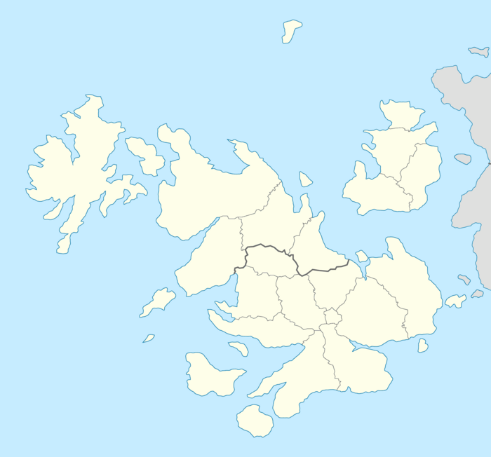
1. Groçe-Rouvere
2. Sant-Leon
3. Norde-Pazhe
1.
Cabierrès
Escáran
Giron
Sant-Albère
Carnát
Gasça
Bosç
Larogès
Ordeça
Marná
Orsane
Marvalso
Sinflaren
Bristala
3.
Farraighferg
Auchnaill
Drumoch
Glennaig
Tarfon
2.
North
Esermian Ocean | |
| Ordeça | Mabièla | 3,996,766 | ||
| Larogès | Guisçon | 3,593,372 | ||
| Cabierrès | Carròna | 3,585,003 | ||
| Sant-Albère | Peirá | 3,385,662 | ||
| Bosç | Lacas | 2,921,445 | ||
| Marná | Montesá | 2,877,293 | ||
| Orsane | Guillá | 2,873,489 | ||
| Gasça | Lorrega | 2,381,680 | ||
| Carnát | Nannsàd | 1,999,482 | ||
| Escáran | Terrès | 912,187 | ||
| Giron | Vaiçá | 728,913 | ||
| Total | 36,614,134 | |||
| Glennaig | Scallàch | 3,276,419 | ||
| Tarfon | Kinfoy | 1,987,930 | ||
| Drumoch | Muire | 1,737,570 | ||
| Auchnaill | Casadel | 477,878 | ||
| Farraighferg | Mallaraïg | 449,336 | ||
| Total | 7,929,133 | |||
| Marvalso | Vàned | 1,221,404 | ||
| Bristalan | Harnvo | 907,952 | ||
| Sinflaren | Kirkinn | 866,975 | ||
| North Pazhe | Sornaberg | 484,351 | ||
| Total | 3,480,682 | |||

.
Overseas territories
Volain is currently in possession of 14 overseas territories, most of which were gained from colonial expansion since the 16th-century. Five of these territories are uninhabitable and are not counted administratively, but are still considered official Volene territory. Four territories are considered a territory of their respective republics and are governed similarly; Illes and West Palies for Ancelon, the Filipè Isles for Tirlean, and Sant-Leon for Pazhe. All other overseas holdings are counted as part of the Greater Dominion as a whole, but generally do not hold and jurisdictional authority. One exception to administrative consideration is the Filipè Isles, which although an extension of Tirle territory, is largely uninhabitable and only home to temporary research outposts.
| Name | Location | Capital | Notes |
|---|---|---|---|
| Alanè | South Esermian Ocean | Uninhabited | Uninhabitable volcanic island measuring 384m in height. |
| Filipè Isles | North Esermian Ocean | Uninhabited | Uninhabitable archipelago within the Northern Frost Circle, with various VNRI research and weather stations. |
| Gaupán | West Jastrun Ocean | Melavu | Jungle atoll southeast of Armonidas. Home to various rare subtropical animal species. |
| Hiberná | North Esermian Ocean | Cubosava | Alpine island chain off the southeast coast of the Courdan North ice shelf. Populated by small fishing communities. |
| Illès | Esermian Ocean | Cresta-Lamon | Pair of islands 2,200km west of Volain. Popular tourist location for its historical landmarks and naval forts. |
| Laçarès | Esermian Ocean | Toramellà | Small island 400km south of Volain. Historical hiding place of Castanian merchant Marco Brugalla. |
| Macarè | Esermian Ocean | Uninhabited | Small volcanic archipelago located on the equator 650km north of The Espraries. Last erupted in 1986 causing disruption to worldwide air transit. |
| Rèveira Islands | Armonidas | Váso Deglais | Series of large tropical islands centrally located in Armonidas. Popular tourist and resort destination. |
| Sant-Esobèl | North Cascadia | Uninhabited | Small fortress island 320km east of Morovia. The historical fortress is close to collapse from erosion despite conservation efforts. |
| Sant-Leon | North Esermian Ocean | Mont Estapia | Large island 500km north of Volain once home to exiled Doxanistic missionaries. Remains an important site for pilgrims and worshipers. |
| Sant-Marc | Terra Sparia Divide | Fort Balsán | Small archipelago and naval base for the Armonidas Fleet. Harbour renovated in 2012 as part of national military refitting. |
| Sant-Robèrte | North Esermian Ocean | Uninhabited | Small atoll 1,500km northeast off the coast of Varland. Was used as a test site for numerous atomic tests by Volene during the 1960s. |
| Tarpaná | North Esermian Ocean | Cobierna Bay | Small islands 1,300km east of the Jastrun Confederation. Historical stopping point for 16th-century explorer voyages. |
| West Pallès | West Cascadia | Pordacal | Large island archipelago situated in West Cascadia. Has been under direct Volene control since the 1978 Morovian coup. |