Esermia
This article is incomplete because it is pending further input from participants, or it is a work-in-progress by one author. Please comment on this article's talk page to share your input, comments and questions. Note: To contribute to this article, you may need to seek help from the author(s) of this page. |
 | |
| Area | 24,871,330 km2 (9,602,870 sq mi)a |
|---|---|
| Population | - |
| Population density | - |
| GDP (nominal) | ᴇ20.4 trillion |
| GDP (PPP) | ᴇ24.8 trillion |
| GDP per capita | ᴇ31,280 |
| HDI | |
| Demonym | Esermian |
| Countries | 22 sovereign states: 1 uninhabited territory: |
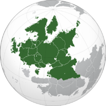
Esermia is a mainland continent centrally-located on Arcaeius. Esermia is bordered by the Esermian Ocean to the west, the Trilumic Ocean to the east, and the Terra Sparia Divide to the south. It is collectively the third largest continent in Arcaeius, after Terra Sparia and North Jastrun. Esermia is geographically separated from Kimena in the east by the Strasian Gulf, River Strasia and Karliv Sea. The Voglodura Mountain Range serves as the natural border between Esermia and Siradia to the south. The continent also extends to the northeast to meet North Jastrun at the Galloway Shoal.
Esermia covers 24,871,330 square kilometres (9,602,870 sq mi), or approximately 16.28% of Arcaeius' surface (5.38% of land area). There are a total of 22 sovereign states in Esermia, with Skonia being the largest. The second largest nation is Prokhogorsk, which is considered the geographical, political, and cultural buffer between Esermia, Siradia and Kimena. There are also 3 sovereign states that have limited recognition; South Rrepezhia, Vlachia, and North Ladnia. The uninhabited region of Hvitlund is geographically part of Esermia, but is not politically or militarily administered, as declared by international law. The climate of Esermia varies, with particularly temperate summers and cold winters, dry and coastal climates in regions surrounding the Parazin Sea, and harsh cold to the north and far northeast.
Historically, Esermia and its cultures are considered to be the foundation of nomadic and metallurgic civilizations, and initiators of the ages of Antiquity. Civilizations such as the Baaten Empire lead to great technological advancements and innovation after the start of the Common Era and during the Age of Settlement. The 14th century saw the rise of nobility within Esermia and great political and societal change. The Insight Era saw the advancement of modern sciences and the clash of great military powers. The Blackpowder Wars, which started in the early 17th century, shaped the political and military structures of various nations, and brought about a series of unresolved conflicts between cultural powers. As imperial governments were vulnerable after years of rule, republican governments became common during the 19th century. The political climate of Esermia would be concreted by the First and Second Esermian Wars during the first half of the 20th century, with socialism emerging as a dominant political idealogy in eastern Esermia while democracy became favoured in the west. By the mid to late 1900s, Esermia would become ideologically and socially divided with the formations of the intergovernmental military alliances of the Esermian Strategic Treaty (EST) and United Socialist Coalition (UNISOC), both designed as deterrents to the rising threat of nuclear conflict. Despite this, many small conflicts around Esermia still continue to the present day.
Definition
Clickable map of Esermia, showing the continental boundaries with Kimena and Siradia
Key: blue: states with contigious transcontinental boundaries;
green: countries not geographically in Esermia, but closely associated with the continent
History
Geography

Climate
Geology
Flora and fauna
Politics
List of states and territories
| Flag | Symbol | Name | Area (km2) |
Population |
Population density (per km2) |
Capital | Name(s) in official language(s) |
|---|---|---|---|---|---|---|---|
| Ameiss | 34,880 | 5,603,898 | 160.6 | Tetaburg | Lycora | ||
| Bavmark | 117,750 | 23,810,921 | 202.21 | Baaten | Bavmarca | ||
| Bronheim | 514,690 | 28,430,298 | 55.23 | Kohlen | Bronheimen | ||
| Brunswyck | 151,540 | 17,234,122 | 113.72 | Friestad | Brunsvik | ||
| Bilania | 1,283,020 | 7,821,470 | 6.09 | Tulburqol | Bılan | ||
| Colcha | 396,560 | 36,023,928 | 90.84 | Niedermeyer | Kolchen | ||
| Herastadt | 140,910 | 34,736,912 | 246.51 | Piragon | Hερaτaлa (Herastadas) | ||
| Ladnia | 51,360 | 5,123,820 | 99.76 | Vosladnia | Ladnaya | ||
| Mortenland | 142,550 | 12,023,992 | 84.34 | Stalheim | Mortenlund | ||
| Mossia | 39,140 | 2,308,200 | 58.97 | Baikav | Mossıu | ||
| New Colcha | 953,640 | 100,080,928 | 104.94 | Manstedten | Niekolchen | ||
| Normanfara | 862,119 | 65,392,231 | 75.85 | Deora | Normanfæra/Normanfarena | ||
| Ostroci | 3,419,950 | 253,329,184 | 70.07 | Strazhimr | Ostročı | ||
| Petschek | 1,259,010 | 53,092,345 | 42.16 | Hvanisjburg | Ԓтчэка (Petjeka) | ||
| Prokhogorsk | 4,218,950 | 191,730,116 | 45.44 | Darovskiya | Прoкhогoрскa (Prokhogorska) | ||
| Rodvia | 377,800 | 20,928,327 | 55.39 | Tolevka | Иɑdıvɑı (Radivai) | ||
| Skonia | 4,938,620 | 47,109,302 | 9.53 | Olhavn | Skånien/Skonien | ||
| Ulveland | 849,697 | 42,283,890 | 49.76 | Valsta | Ølvelund/Ulvelund | ||
| Vadenia | 234,771 | 35,092,326 | 149.47 | Cavrila | Vadenie | ||
| Vlazenice | 2,812,684 | 23,902,021 | 8.49 | Kazisto | Vlajenık | ||
| Volain | 795,182 | 48,023,949 | 60.39 | Rouvere | Volienne/Faleinn | ||
| Vrenland | 207,010 | 9,120,232 | 44.05 | Tir | Vrinlund | ||
| Total | 22 | 23,265,570 | 1,073,212,412 | ||||
The following are de facto independent states or countries geographically within Esermia which hold limited to no international recognition.
| Flag | Symbol | Name | Area (km2) |
Population |
Population density (per km2) |
Capital | Name(s) in official language(s) |
|---|---|---|---|---|---|---|---|
| North Ladnia | - | Nar Ladnaya | |||||
| South Rrepezhia | 197,000 | Nakhima | Rrpzhıu Sedeyu | ||||
| Vlachia | - | Wlachyie |

