Portal:Kylaris/Features: Difference between revisions

Jump to navigation Jump to search
No edit summary
No edit summary
 
(52 intermediate revisions by 6 users not shown)
Line 1: Line 1:
<div style="float:left;margin:0.5em 0.9em 0.4em 0;">[[File:Centro_SP2.jpg|200px]]</div> '''Castelonovo''' ({{wp|Help:IPA/Portuguese|[''kɐstʃelɔnovo'']}}), officially the '''Municipality and Federal Capital of Castelonovo''' ({{wp|Portuguese language|Iustian}}: ''Município e Capital Federal de Castelonovo''), is the capital and largest city of [[Belmonte]]. According to the last demographic census made in 2018, the general population of the city and its metropolitan area corresponds to 3,724,976 inhabitants.
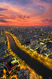
[[File:DJI_0196-HDR-Pano.jpg|right|thumb|200px|An evening view of a canalised tributary of the Buiganhingi as it flows through Naimhejia, the second biggest city in Dezevau]]
 
'''Urban planning in Dezevau''' is the planning and design of cities in [[Dezevau]]. It has a history that stretches back two thousand years or more, though modern urban planning only emerged after Dezevauni independence in 1941. It is a key academic, governmental and political concern, influenced strongly in the present day by the nature of local and federal power, and by the ideal of a democratic and socialist economy; its importance relates to the high level of urbanisation in Dezevau, which is about 70%. The most significant urban planning agencies are the district planning commissions, but like many other political processes in Dezevau, consultation with and input from both higher and lower governmental strata are crucial.  
Founded by {{wp|bandeirantes}} in the 16th century, Castelonovo was located between several trade routes that transported goods to villages and markets, which made the small city become within a few years an important commercial centre to the colony. Also, the rough terrain was frequently used as a natural barrier against indigenous attacks, which was another decisive factor for the upcoming centralization and transference of various public services and institutions that were formerly situated in several coastal cities to there. Soon after the [[Asterian War of Secession|Belmontese independence]], the city already was the most important of the entire country, but it only became the national capital and its own province after the establishment of the [[History of Belmonte|republic]] in 1819. ('''[[Castelonovo|See more...]]''')
('''[[Urban planning in Dezevau|See more...]]''')
<hr>
<div style="float:left;margin:0.5em 0.9em 0.4em 0;">[[File:Mambiza_pic.PNG|200px]]</div> '''Mambiza''' ({{wp|Help:IPA/English|/'mæmbi:za/}}; officially '''Sainte-Germaine''' until 1970) is the largest city in [[Garambura]]. The city has one of the largest designated metropolitan areas in Garambura, at 1,253.9km<sup>2</sup> (481.4mi<sup>2</sup>), and an urban population of 4,489,140 in 2014, with a total population of just over 4.5 million inhabitants. Mambiza itself is a metropolitan province of Garambura, and is represented by its elected governor Rupenyu Majange. The city sits on the expansive Gonda Delta and its coastal location makes it a popular destination for global trade.
 
The city was founded as a trading outpost in 1656 by [[Gaullica|Gaullican]] merchants, who named the city ''Sainte-Germaine'' after the [[Solarian Catholic Church|Sotirian]] venerated figure. It served as a stopover for trade between [[Euclea]] and southern [[Coius]], namely [[Xiaodong]] and [[Senria]], and so the city's wealth grew under the Gaullicans. It was designated as the capital of [[Baséland]] when it fell under full Gaullican sovereignty in 1813, and was designated a city in 1814. Mambiza was the site of [[Charles Dumont]]'s famous ''Droits de l'homme'' speech in 1919, before he was executed in the city by national functionalists. Many of the city's inhabitants were conscripted during the [[Great War (Kylaris)|Great War]]. ('''[[Mambiza|See more...]]''')


<div style="text-align:right>[[File:KylarisRecognitionAchievement.png|25px]] '''{{cl|Kylaris Articles of Recognition|See all articles of recognition}}'''</div>
<div style="float:left;margin:0.5em 0.9em 0.4em 0;">{{Region icon Kylaris}}</div>

Latest revision as of 23:38, 1 March 2024

An evening view of a canalised tributary of the Buiganhingi as it flows through Naimhejia, the second biggest city in Dezevau

Urban planning in Dezevau is the planning and design of cities in Dezevau. It has a history that stretches back two thousand years or more, though modern urban planning only emerged after Dezevauni independence in 1941. It is a key academic, governmental and political concern, influenced strongly in the present day by the nature of local and federal power, and by the ideal of a democratic and socialist economy; its importance relates to the high level of urbanisation in Dezevau, which is about 70%. The most significant urban planning agencies are the district planning commissions, but like many other political processes in Dezevau, consultation with and input from both higher and lower governmental strata are crucial. (See more...)
KylarisRecognitionAchievement.png See all articles of recognition
Template:Region icon Kylaris