Seogwang Province: Difference between revisions
Jump to navigation
Jump to search
(Created page with "{{Under Construction}} {{Infobox country |native_name = 서광도 |conventional_long_name = Seogwang Province |common_name = |ima...") |
mNo edit summary |
||
| (3 intermediate revisions by the same user not shown) | |||
| Line 1: | Line 1: | ||
{{Under Construction}} | {{Under Construction}} | ||
{{Infobox | {{Infobox settlement | ||
| | | name = Seogwang Province | ||
| | | settlement_type = [[Administrative Areas of Zhenia#Provinces|Province]] | ||
| | | image_skyline = | ||
|image_flag | | image_alt = | ||
| | | image_caption = | ||
| | | image_flag = Flag of Seogwang Province 2.png | ||
| | | flag_alt = Flag of Seogwang Province. | ||
| | | image_seal = | ||
| | | seal_alt = | ||
| | | image_shield = | ||
| | | shield_alt = | ||
| | | etymology = | ||
| nickname = | |||
|image_map | | motto = | ||
| | | image_map = Guangseo Province Map in Zhenia.png | ||
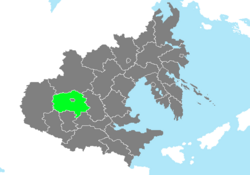
|map_caption | | map_alt = Location of Seogwang Province in Zhenia marked in green. | ||
| | | map_caption = Location of Seogwang Province in Zhenia. | ||
| | | pushpin_map = | ||
| | | pushpin_map_alt = | ||
| | | pushpin_map_caption = | ||
| | | pushpin_label_position = | ||
| | | coordinates = <!-- {{coord|latitude|longitude|type:city|display=inline,title}} --> | ||
| | | coor_pinpoint = | ||
| | | coordinates_footnotes = | ||
| | | subdivision_type = Country | ||
| | | subdivision_name = [[Zhenia]] | ||
| | | subdivision_type1 = Capital | ||
| | | subdivision_name1 = [[Jungsan]] | ||
| subdivision_type2 = Largest City | |||
| subdivision_name2 = [[Daeheung]] | |||
| subdivision_type3 = | |||
| subdivision_name3 = | |||
| established_title = Reorganization into a Province | |||
| established_date = December 8, 1909 | |||
| | | founder = | ||
| | | seat_type = | ||
| | | seat = | ||
| | | government_footnotes = | ||
| | | government_type = | ||
| | | governing_body = | ||
| | | leader_party = [[People's Action Party|P]] | ||
| | | leader_title = Governor | ||
| | | leader_name = Lee Juseop | ||
| | | leader_title1 = | ||
| | | leader_name1 = | ||
| | | leader_title2 = | ||
| | | leader_name2 = | ||
| | | leader_title3 = | ||
| | | leader_name3 = | ||
| | | leader_title4 = | ||
| | | leader_name4 = | ||
| | | unit_pref = Metric | ||
| | <!-- ALL fields with measurements have automatic unit conversion --> | ||
| | <!-- for references: use <ref> tags --> | ||
| | | area_footnotes = | ||
| | | area_urban_footnotes = <!-- <ref> </ref> --> | ||
| area_rural_footnotes = <!-- <ref> </ref> --> | |||
| | | area_metro_footnotes = <!-- <ref> </ref> --> | ||
| | | area_magnitude = <!-- <ref> </ref> --> | ||
| | | area_note = | ||
| | | area_water_percent = 1.43 | ||
| | | area_rank = 6th | ||
| | | area_blank1_title = | ||
| | | area_blank2_title = | ||
| | <!-- square kilometers --> | ||
| | | area_total_km2 = 258020.02 | ||
| | | area_land_km2 = 254330.33 | ||
| | | area_water_km2 = 3689.69 | ||
| | | area_urban_km2 = | ||
| | | area_rural_km2 = | ||
| | | area_metro_km2 = | ||
| | | area_blank1_km2 = | ||
| | | area_blank2_km2 = | ||
| | | elevation_footnotes = | ||
| | | elevation_m = | ||
| | | population_as_of = 2020 | ||
| | | population_footnotes = | ||
| | | population_total = 28,327,815 | ||
| | | population_density_km2 = 109.8 | ||
| | | population_note = | ||
| | | population_demonym = Seogwangese | ||
| | | timezone1 = [[Time in Zhenia#Zhenia Western Standard Time|ZWST]] | ||
| | | utc_offset1 = +7 | ||
| timezone1_DST = | |||
| utc_offset1_DST = | |||
| | | postal_code_type = Federal Postal Code | ||
| postal_code = 30001-30999 | |||
| | | area_code_type = Provincial Code | ||
| | | area_code = SG | ||
| | | iso_code = | ||
| | | website = www.seogwang.sg.zhen | ||
| | | footnotes = | ||
| | |||
| | |||
| | |||
| | |||
|footnotes | |||
}} | }} | ||
'''Seogwang Province''' ([[Zhenian language|Zhenian]]: '''서광도'''), is a [[Zhenia|Zhenian]] [[Administrative Areas of Zhenia#Provinces|province]] located in [[Western Zhenia]]. Covering an area of | '''Seogwang Province''' ([[Zhenian language|Zhenian]]: '''서광도'''), is a [[Zhenia|Zhenian]] [[Administrative Areas of Zhenia#Provinces|province]] located in [[Western Zhenia]]. Covering an area of almost 260,000 square kilometers and home to over 28 million residents, it is the sixth largest province in the nation by area as well as its 10th most populous province. | ||
==Etymology== | |||
==History== | ==History== | ||
==Geography== | ==Geography== | ||
==Politics== | |||
===Government=== | |||
==Demographics== | |||
==Economy== | ==Economy== | ||
| Line 114: | Line 113: | ||
===Transportation=== | ===Transportation=== | ||
==Culture== | |||
==See Also== | |||
* [[Administrative Areas of Zhenia]] | |||
* [[Provinces of Zhenia]] | |||
{{Template:Zhenia NavBox}} | {{Template:Zhenia NavBox}} | ||
[[Category:Zhenia]] | [[Category:Zhenia]] | ||
Latest revision as of 12:59, 2 April 2020
Seogwang Province | |
|---|---|
 Location of Seogwang Province in Zhenia. | |
| Country | Zhenia |
| Capital | Jungsan |
| Largest City | Daeheung |
| Reorganization into a Province | December 8, 1909 |
| Government | |
| • Governor | Lee Juseop (P) |
| Area | |
| • Total | 258,020.02 km2 (99,622.09 sq mi) |
| • Land | 254,330.33 km2 (98,197.49 sq mi) |
| • Water | 3,689.69 km2 (1,424.60 sq mi) 1.43% |
| • Rank | 6th |
| Population (2020) | |
| • Total | 28,327,815 |
| • Density | 109.8/km2 (284/sq mi) |
| Demonym | Seogwangese |
| Time zone | UTC+7 (ZWST) |
| Federal Postal Code | 30001-30999 |
| Provincial Code | SG |
Seogwang Province (Zhenian: 서광도), is a Zhenian province located in Western Zhenia. Covering an area of almost 260,000 square kilometers and home to over 28 million residents, it is the sixth largest province in the nation by area as well as its 10th most populous province.
