Lengshan Gulf: Difference between revisions
No edit summary |
No edit summary |
||
| Line 32: | Line 32: | ||
*[[Gangkou]] | *[[Gangkou]] | ||
*[[Lengshan]] | *[[Lengshan]] | ||
*[[Zhenquan]] | |||
*[[Chungbaek]] | |||
*[[Huinan]] | |||
}} | }} | ||
| reference = | | reference = | ||
Latest revision as of 15:54, 12 March 2024
| Lengshan Gulf | |
|---|---|
 | |
| Location | Southwest Ausiana |
| Type | Sea/Gulf |
| Basin countries | Tosichi, Gangkou, Yuan |
| Surface area | 120,000 km2 (74,564 mi2) |
| Average depth | 350 m (1,150 ft) |
| Max. depth | 2,716 m (8,911 ft) |
| Frozen | never |
| Settlements | |
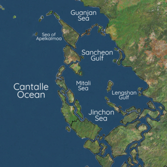
The Lengshan Gulf is a marginal sea of the Eastern Cantalle Ocean. It is bound by western Ausiana with the basins of Tosichi, Yuan, and Gangkou surrounding it, with connections to the Jinchon Sea and Sancheon Gulf. It is a region of tremendous economic and geostrategic importance, as nearly a third of global maritime trade is shared between it, the Jinchon Sea, and Sancheon Gulf areas. Huge oil and natural gas reserves are believed to lie beneath its seabed. It also contains lucrative fisheries, which are crucial for the food security of millions in Southwest Ausiana.
The Gulf is itself a subject of an international dispute over its political status. As the People's Republic of Yuan claims to enjoy "sovereignty, sovereign rights and jurisdiction over the Lengshan Gulf" and regards the waterway as "internal territorial waters" instead of being international waters, this means that the Yuaneze government denies any foreign vessel having the freedom of navigation to cross the strait without Yuaneze official consent. This position has drawn strong objections from Zamastan, most of WEDA and the ANS, Siniapore, and Kalea. Several contested territorial claims by nations has led to the ongoing Jinchon Sea crisis.