Geography of Zhenia: Difference between revisions
No edit summary |
|||
| Line 56: | Line 56: | ||
[[File:Zhenia 1x Koppen climate map.png|250px|thumb|right|{{wp|Koppen climate|Koppen climate map}} of Zhenia.]] | [[File:Zhenia 1x Koppen climate map.png|250px|thumb|right|{{wp|Koppen climate|Koppen climate map}} of Zhenia.]] | ||
Zhenia is home to a highly diverse climate, due to tremendous differences in latitude, longitude and altitude throughout its territory. Spanning between the latitude lines of 20.8° and 52.6° N, Zhenia's climate spectrum runs from hot in the south to cold in the northeast and humid in the east along the coastline to dry in the west, resulting in a climate that ranges from {{wp|tropical climate|tropical}} in the south, {{wp|subarctic climate|subarctic}} in the northeast and {{wp|desert climate|desert}} in the west. Climate in much of Zhenia is influenced by seasonal winds and monsoons, bringing in a yearly oscillatory cycle of {{wp|dry season|dry seasons}} and {{wp|wet monsoons}}, in which a bulk of annual precipitation is highly concentrated in certain months of the year. Warm and moist air from the Hanmaric Ocean results in high precipitation and typhoons during the summer season, while the cold and dry continental air from the north dominates the winter season with cold weather and far less precipitation. | |||
==Natural disasters== | ==Natural disasters== | ||
Revision as of 01:00, 31 March 2020
 | |
| Continent | Tarsis |
|---|---|
| Region | Themis |
| Area | |
| • Total | 5,423,777.2 km2 (2,094,132.1 sq mi) |
| • Land | 94.34% |
| • Water | 5.66% |
| Borders | Yinguo |
| Highest point | Mount Changjin 8,782.8 m |
| Lowest point | Lake Sagyeong -87 m |
| Longest river | Taimir River 5,429 km |
| Largest lake | Lake Jinsa 6,507.3 km2 |
| Climate | Generally temperate and continental climate, arid/semi-arid in west, alpine tundra in the central-western mountains; monsoon-influenced temperate climate in the central and east coasts, subtropical in the south |
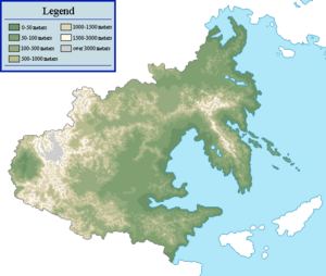
| Terrain | Mountains in center-west and southwest and along the Danguk Peninsula, plains in the center, hills in the south |
| Natural Resources | arable land, coal, iron ore, bauxite, uranium, petroleum, natural gas, rare-earth minerals, timber |
| Environmental Issues | air pollution, water pollution, desertification, deforestation, soil erosion |
Zhenia is a nation located on the eastern coasts of the continent of Tarsis in Themys, primarily facing the Hanmaric Ocean. Zhenian geography shows great physical diversity, ranging from fertile lowlands and foothills found along most of the Golden Arc area, to the semi-arid basins and mountains to the west. Both due to terrain and climate, a vast majority of the nation's population and agricultural potential are focused in the east, particularly near the Gulf of Danguk.
Area
Tectonics
Physical regions
General characteristics
Eastern Zhenia (Danguk Peninsula)
Northern Zhenia
Central Zhenia
Southern Zhenia
Western Zhenia
Climate

Zhenia is home to a highly diverse climate, due to tremendous differences in latitude, longitude and altitude throughout its territory. Spanning between the latitude lines of 20.8° and 52.6° N, Zhenia's climate spectrum runs from hot in the south to cold in the northeast and humid in the east along the coastline to dry in the west, resulting in a climate that ranges from tropical in the south, subarctic in the northeast and desert in the west. Climate in much of Zhenia is influenced by seasonal winds and monsoons, bringing in a yearly oscillatory cycle of dry seasons and wet monsoons, in which a bulk of annual precipitation is highly concentrated in certain months of the year. Warm and moist air from the Hanmaric Ocean results in high precipitation and typhoons during the summer season, while the cold and dry continental air from the north dominates the winter season with cold weather and far less precipitation.
