Selayar: Difference between revisions
m (Changed category Europa to Eurth and added Alharu category) |
mNo edit summary |
||
| Line 215: | Line 215: | ||
[[Category:Nations]] | [[Category:Nations]] | ||
[[Category:Eurth]] | [[Category:Eurth]] | ||
[[Category:Selayar]] | [[Category:Selayar]] | ||
Revision as of 20:29, 24 April 2020
This article is incomplete because it is pending further input from participants, or it is a work-in-progress by one author. Please comment on this article's talk page to share your input, comments and questions. Note: To contribute to this article, you may need to seek help from the author(s) of this page. |
Monarchy of Selayar Watāhama mi Heraʻā (Heraan) | |
|---|---|
| Motto: Rimamura Wavanga "Prosperous Land" | |
| Anthem: Risutiva mu Heraʻā "Long Live Selayar" | |
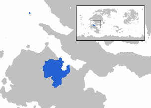
 Area controlled by Selayar shown in blue | |
| Status | Independent State |
| Location | Northern Aurelia |
| Capital | Wanaveraʻa |
| Largest city | Mawura |
| Official languages | Heraan |
| Recognised regional languages | Reyan, Vanawan, Ruawese, Vayarese |
| Ethnic groups (2015) | |
| Religion | Aturātuʻa |
| Demonym(s) | Selayari |
| Government | Federal parliamentary elective constitutional monarchy |
• Monarch | Manuwesa II |
• Prime Minister | Huti Manaranga |
| Legislature | Varai mi Tama |
| Varai mi Taravanga | |
| Varai mi Ranga | |
| Establishment | |
• Wanana Rebellion | 1860 - 1865 |
• 18 August Revolution | 18 August 1897 |
• Selayari Succession Crisis | 1958 |
• Treaty of ʻArama | 1 December 1974 |
| Area | |
• Total | 704,324 km2 (271,941 sq mi) |
• Water (%) | negligible |
| Population | |
• 2015 census | 41,332,005 |
• Density | 58.6/km2 (151.8/sq mi) |
| GDP (nominal) | 2017 estimate |
• Total | $867 million |
• Per capita | $20,988 |
| Gini (2017) | 43.2 medium |
| HDI (2017) | high |
| Currency | Nanari |
| Time zone | IST -6 |
| Date format | dd-mm-yyyy (CE) |
| Driving side | left |
| Calling code | +73 |
| Internet TLD | .he |
Selayar (/sə'laːjar/; Heraan: Heraʻā ['heraʔaː]), officially the Monarchy of Selayar (Heraan: Watāhama mi Heraʻā), is a federal monarchy located in northern Aurelia, bordering the Mananama Bay. It is located northeast of Rihan and northwest of Shffahkia. Selayar covers 704,324 square kilometers and has an estimated population of 41,332,005 in 2015. Selayar comprises of 7 ʻArana (state-kingdom), 1 Federal City, and 1 Royal Capital City. Wanavera'a, officially the Royal Capital City of Wanavera'a, is the capital, while Mawura is the largest city in Selayar.
Selayar is one of the most diverse countries on Eurth, owing to its location in the tropics. It's year-round hot and humid temperature along with its dense cover of untouched forests provide habitats for a large number of endemic species. The fertile floodplain on the north supports a dense and bustling population of Selayar, with many rivers flowing through from the Wananga mountains in the east. The floodplain alone hosts an almost three-fourth population of the nation.
Selayar emerged as one of the earliest civilisations in Aurelia, beginning with the rise of Ninaman cultures in early first millennia BCE and the development of rice agriculture. Tenaia Kingdom is widely-recognised as the first major kingdom in Selayar, after uniting the Saraian Valley under its dominion around fourth century CE. The arrival of Shffahkian colonist early in the 1400s brought many novel things to the kingdom, and with it, constant warfare. Only in the early sixteenth century, did Reyan Empire once again united the Valley, and went on an aggressive expansion campaign. The Empire reached its zenith in late 1790, spanning almost all of the southern Manamanan coast and land further inland, matched only by the Shffahkian Empire in the southeast. Selayar, as it is known now, grew out of the Wananan Rebellion in 1850, which shifted the power from Reyan capital Terata to the former vassal of the Empire, Heraa. Selayar once again went on an expansionist campaign, only ended by the Civil War that ravaged the country for more than a decade, starting in 1959, temporarily splitting the country into two governments. Reconciliation and reformation followed the post-Civil War period, though small-scale rebel activity persists. The election of King Manuwesa II as the Tāha is regarded as a transition to a new modern era of Selayar.
The Economic Reform of 1974 is hailed as a breakthrough reformation in the economic sector, as the virtually destroyed economy of Selayar rose up again as the "Tiger of Aurelia" in the late 1980s. Selayar's economy has seen an annual growth rate of more than 7 percent from the late 1970s, and well into the late 1990s. Oil price boom is regarded as the main factor in Selayar's economic recovery, along with the growing industrial base that followed decentralisation of Selayari economy. The annual growth rate has slowed down as the nation entered the 21st century, and with it, a decrease in oil production contribution to Selayar's economy.
Selayar is a member of several multilateral organisations, including Manamana League. There has been a recent talk for the inclusion of Selayar into Aurelian League.
Etymology
The name Selayar is believed to derive from Old Reyan name for the heavily-populated floodplains in central Selayar, Sarahira Valley. When Shffahkians explorers first entered the region of present-day Selayar, they transcribed the name "Sarahira" as "Saraire". This would later evolve into the present name "Selayar", where today it refers to the country as a whole, not just the area around the floodplains.
The native name in Heraan, Heraʻā, a cognate of Old Reyan name Sarahira, is the namesake of the Heraans and its language, where it used to mean 'valley'. It came from the fact that the Heraan's homeland is the Heraan Valley in Tarema, and later applied to the Heraans land, and ultimately, the nation as a whole which is dominated by the Heraans both politically and culturally.
History
Prehistoric
Rise of the Reyan Empire
Heraʻa Domination
The Enlightenment
Time of Crises
Haravatu Era
Geography
Government and politics
Selayar is a federal parliamentary elective constitutional monarchy.
Administrative Divisions
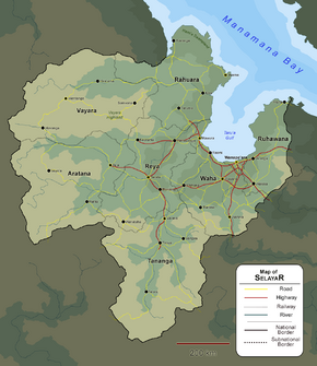
Selayar consists of 6 ʻArana (equivalent to province), 1 Federal City, and 1 Royal Capital City.
Economy
Demography
Cities
Largest cities or towns in Selayar
2018 census | |||||||||
|---|---|---|---|---|---|---|---|---|---|
| Rank | ʻArana | Pop. | Rank | ʻArana | Pop. | ||||
| 1 | Mawura | Federal city | 2,968,564 | 11 | Tirova | Tananga | 481,446 | ||
| 2 | Wanaveraʻa | Federal city | 1,857,511 | 12 | Taʻa | Aratana | 430,662 | ||
| 3 | Ruwara | Waha | 1,310,673 | 13 | Taruma | Rahuara | 419,311 | ||
| 4 | Terata | Reya | 1,148,375 | 14 | Keorama | Aratana | 394,340 | ||
| 5 | Vanaʻa | Tananga | 937,114 | 15 | Wanataha | Aratana | 368,122 | ||
| 6 | Roroima | Reya | 750,450 | 16 | Wentanga | Vayara | 355,105 | ||
| 7 | Wahina | Ruhawana | 680,245 | 17 | ʻArama | Rahuara | 302,439 | ||
| 8 | Watesa | Ruhawana | 612,398 | 18 | Hiraʻuma | Vayara | 287,556 | ||
| 9 | Weruwanga | Reya | 523,964 | 19 | ʻAranga | Ruhawana | 280,834 | ||
| 10 | Raomi | Waha | 504,387 | 20 | Aʻaranga | Rahuara | 252,494 | ||
Culture
This template may be deleted.


