Mount Monjara: Difference between revisions
Jump to navigation
Jump to search
Lyooonheimer (talk | contribs) No edit summary |
Lyooonheimer (talk | contribs) No edit summary |
||
| Line 9: | Line 9: | ||
| photo_alt = | | photo_alt = | ||
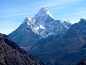
| photo_caption = Photo from 2016, Monjara from a distance | | photo_caption = Photo from 2016, Monjara from a distance | ||
| map = | | map = | ||
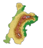
| map_image = | | map_image = [[File:Screenshot 2022-01-19 195028.png|150px]] | ||
| map_alt = | | map_alt = | ||
| map_caption = | | map_caption = Location of Mount Monjara. | ||
| map_relief = | | map_relief = | ||
| map_size = | | map_size = | ||
Revision as of 19:52, 19 January 2022
| Mount Monjara | |
|---|---|
माउन्ट मोन्जारा | |
 Photo from 2016, Monjara from a distance | |
| Highest point | |
| Elevation | 7,963 m (26,125 ft) |
| Naming | |
| Etymology | "Mother's Peak of the World" |
| Geography | |
| Location | Central Mahana |
| Parent range | Samripe Mountain Range |
Mount Monjara (Mahanan: माउन्ट मोन्जारा) is one of Eurth's highest mountain points (7,963m).
