Serëtanz: Difference between revisions
No edit summary |
m (Text replacement - "Mar'theqa" to "Martheqa") |
||
| Line 11: | Line 11: | ||
| image = Serëtanz delta.jpg | | image = Serëtanz delta.jpg | ||
| image_size = | | image_size = | ||
| image_caption = View over the Serëtanz delta below [[ | | image_caption = View over the Serëtanz delta below [[Martheqa]] | ||
<!-- *** Country *** --> | <!-- *** Country *** --> | ||
| country = {{flag|Trellin}}, {{flag|Hysera}} | | country = {{flag|Trellin}}, {{flag|Hysera}} | ||
| Line 22: | Line 22: | ||
| tributaries_left = {{hlist|Avarel|Darakan|Keztalem|Eliosanti}} | | tributaries_left = {{hlist|Avarel|Darakan|Keztalem|Eliosanti}} | ||
| tributaries_right = {{hlist|Etxan|Tudri'i|Sa'arem|(Tecih)|Hysmir River}} | | tributaries_right = {{hlist|Etxan|Tudri'i|Sa'arem|(Tecih)|Hysmir River}} | ||
| city = {{hlist|Vortún|[[Vedalera]]|Kemaki|[[ | | city = {{hlist|Vortún|[[Vedalera]]|Kemaki|[[Martheqa]]|[[Tanzigar]]}} | ||
| landmark = | | landmark = | ||
<!-- *** Dimensions *** --> | <!-- *** Dimensions *** --> | ||
| Line 51: | Line 51: | ||
}} | }} | ||
The '''Serëtanz''' is the largest river in [[Trellin]], by both overall length and volume discharged. Rising in the rainforest of central [[Retikh]], it flows 810 kilometres, most of this length being in the province of [[Saheri]] where it flows through the city of [[Vedalera]], before entering the [[Sea of Jajich]] below [[ | The '''Serëtanz''' is the largest river in [[Trellin]], by both overall length and volume discharged. Rising in the rainforest of central [[Retikh]], it flows 810 kilometres, most of this length being in the province of [[Saheri]] where it flows through the city of [[Vedalera]], before entering the [[Sea of Jajich]] below [[Martheqa]], at [[Tanzigar]]. | ||
==Toponymy== | ==Toponymy== | ||
| Line 67: | Line 67: | ||
[[File:Serëtanz gorge.jpg|thumb|left|250px|The I'pethë canyon]]Leaving Lake Tecihqa, the Serëtanz passes through the I'pethë canyon which forces it to narrow to as little as three hundred metres across. The river then turns due south, returning to its westward course after joining the Keztalem, and widens substantially as it passes through the city of Kemaki. Ten kilometres from the western border of Saheri, the Serëtanz is joined by the Hysmir River. | [[File:Serëtanz gorge.jpg|thumb|left|250px|The I'pethë canyon]]Leaving Lake Tecihqa, the Serëtanz passes through the I'pethë canyon which forces it to narrow to as little as three hundred metres across. The river then turns due south, returning to its westward course after joining the Keztalem, and widens substantially as it passes through the city of Kemaki. Ten kilometres from the western border of Saheri, the Serëtanz is joined by the Hysmir River. | ||
As it nears the sea, the river begins to spread out, splitting into two main channels around Kherind Island, 381 square kilometres in area. The two channels rejoin south of [[ | As it nears the sea, the river begins to spread out, splitting into two main channels around Kherind Island, 381 square kilometres in area. The two channels rejoin south of [[Martheqa]], where they are met by the Eliosanti, just above the port city of [[Tanzigar]]. The Serëtanz then divides into a number of separate channels, forming a substantial delta where it enters the Sea of Jajich. | ||
==History== | ==History== | ||
In antiquity, the Serëtanz marked the southern border of the [[Hyseran Empire]], providing an easily defensible boundary. A string of outposts along its north bank guarded against attempts at fording the river. During the many Trellinese-Hyseran wars, control of the river was essential for conducting any successful military operation against the other side. Pontoon bridges were deployed infrequently, as the Serëtanz is not below 5 kilometres wide anywhere within 100 kilometres of | In antiquity, the Serëtanz marked the southern border of the [[Hyseran Empire]], providing an easily defensible boundary. A string of outposts along its north bank guarded against attempts at fording the river. During the many Trellinese-Hyseran wars, control of the river was essential for conducting any successful military operation against the other side. Pontoon bridges were deployed infrequently, as the Serëtanz is not below 5 kilometres wide anywhere within 100 kilometres of Martheqa. More regular were attempts to ferry troops across, though in the monsoon season the currents could greatly disrupt coordination. | ||
In the centuries before before the fall of Hysera, the Trellinese began to colonise upriver, founding the city of Vedalera and building a long, stone bridge across at that point. Trade along the Serëtanz became an increasingly important aspect of the Trellinese economy, and the ports at Vedalera and | In the centuries before before the fall of Hysera, the Trellinese began to colonise upriver, founding the city of Vedalera and building a long, stone bridge across at that point. Trade along the Serëtanz became an increasingly important aspect of the Trellinese economy, and the ports at Vedalera and Martheqa prospered along with trade in the seas of Jajich and [[Sea of Velar|Velar]]. | ||
[[Category:Geography of Trellin]][[Category:Rivers]][[Category:Trellin]][[Category:Astyria]] | [[Category:Geography of Trellin]][[Category:Rivers]][[Category:Trellin]][[Category:Astyria]] | ||
Revision as of 19:25, 27 March 2022
| Serëtanz | |
|---|---|
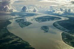
 View over the Serëtanz delta below Martheqa | |
| Location | |
| Country | |
| Region | Retikh, Saheri, Trelum |
| Basin features | |
| Cities | |
| Tributaries | |
| - left |
|
| - right |
|
The Serëtanz is the largest river in Trellin, by both overall length and volume discharged. Rising in the rainforest of central Retikh, it flows 810 kilometres, most of this length being in the province of Saheri where it flows through the city of Vedalera, before entering the Sea of Jajich below Martheqa, at Tanzigar.
Toponymy
The river was originally known in Ahéri as Siqara, or "south river", as it formed the southern boundary of the Ahéri lands and the later Hyseran Empire. Across the river was an uninhabited swamp; beyond that were uncivilised forest peoples who only rarely traded with their distant neighbours.
The name Serëtanz is a compound of the Trellinese word serë, meaning "greater", and Tanz, the name of a river in Aquitayne (and from which Aquitayne draws its name, via the Ethlorek name Aqavatanza). This blatant comparison became of great interest to ethnographers in the late 1800s as they tried to locate the specific river Tanz and so conclusively trace the origins of the Ethlorek migrations. There is no obvious link between the two rivers and their physical geography, however, other than that both have been the main rivers in the original and new Ethlorek homelands.
Course
The Serëtanz rises from the aquifer-fed Merev Cave in the Tambodi rainforest, in the Vekra Retiqa, at an altitude of approximately 560 metres.
It is joined by the slightly smaller Etxan after 17 kilometres and flows roughly westward, being joined by the Tudri'i and the Avarel in turn. Roughly halfway between these two tributaries the river flows through the city of Vortún. Shortly after passing into Saheri it turns southwest and is joined by the Sa'arem, which collects its water from the Vekra Retiqa. At this point the Serëtanz is up to five kilometres wide in the monsoon season and meanders across its extensive floodplain. The ruins of the fortress of Rosnai overlook the river and its surrounding rainforest here from a low ridge.
Substantial levees are in place for twenty kilometres up- and downriver of Vedalera, the largest city on the river's middle course. Its flow has been lessened somewhat in recent years as its flow is used for irrigation, though the volume that enters Lake Tecihqa has only dropped by 3% in the last thirty years. The other major contributor to the lake, the Tecih river, is also the most voluminous of the Serëtanz's tributaries.
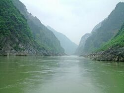
Leaving Lake Tecihqa, the Serëtanz passes through the I'pethë canyon which forces it to narrow to as little as three hundred metres across. The river then turns due south, returning to its westward course after joining the Keztalem, and widens substantially as it passes through the city of Kemaki. Ten kilometres from the western border of Saheri, the Serëtanz is joined by the Hysmir River.
As it nears the sea, the river begins to spread out, splitting into two main channels around Kherind Island, 381 square kilometres in area. The two channels rejoin south of Martheqa, where they are met by the Eliosanti, just above the port city of Tanzigar. The Serëtanz then divides into a number of separate channels, forming a substantial delta where it enters the Sea of Jajich.
History
In antiquity, the Serëtanz marked the southern border of the Hyseran Empire, providing an easily defensible boundary. A string of outposts along its north bank guarded against attempts at fording the river. During the many Trellinese-Hyseran wars, control of the river was essential for conducting any successful military operation against the other side. Pontoon bridges were deployed infrequently, as the Serëtanz is not below 5 kilometres wide anywhere within 100 kilometres of Martheqa. More regular were attempts to ferry troops across, though in the monsoon season the currents could greatly disrupt coordination.
In the centuries before before the fall of Hysera, the Trellinese began to colonise upriver, founding the city of Vedalera and building a long, stone bridge across at that point. Trade along the Serëtanz became an increasingly important aspect of the Trellinese economy, and the ports at Vedalera and Martheqa prospered along with trade in the seas of Jajich and Velar.
