Charlotte (state)
This article is incomplete because it is pending further input from participants, or it is a work-in-progress by one author. Please comment on this article's talk page to share your input, comments and questions. Note: To contribute to this article, you may need to seek help from the author(s) of this page. |
State of Charlotte
État de Charlotte | |
|---|---|
State | |
| Nickname: The Free State | |
| Motto: "Forward" | |
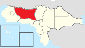
 Map of Rizealand with Charlotte in red | |
| Country | |
| Before Statehood | Providence Territory |
| Capital (and largest city) | Ardougne |
| Joined Federation | July 4, 1796 (4th) |
| Government | |
| • Secretary General | Philip Lucroy (TNC-CRP) |
| • Legislature | Charlotte State Senate |
| • Federal councillors | Appointed
Elected |
| • Federal representatives | |
| Area | |
| • Total | 247,845.34 km2 (95,693.62 sq mi) |
| Population (2021) | |
| • Total | 3,597,600 |
| • Density | 14.52/km2 (37.6/sq mi) |
| Time zone | UTC+9 to +10 (Western/Central) |
| Abbreviation | CH |
| ISO 3166 code | RZ-CH |
| Website | www |
Charlotte, known officially as the State of Charlotte and unofficially as "CH" or "État de Charlotte", is a state in northwestern Rizealand that is bordered by Cassier to the north, Providence to the east, the Capital Territory to the southeast, Lothicania to the south, and New Estmere to the west. Charlotte has a total area of 247,845.34 square kilometers, making it the third largest state and political division of Rizealand. Charlotte also has a population of 3,597,600, making it the seventh most populous state and political entity. Charlotte's capital and largest city is Ardougne. It is also home to several other large cities including East Ardougne, La Salle, and New Verlois.
Etymology
The "State of Charlotte" is named after the Province of Charlotte, a Gaullican administrative division formed out of the eastern half of the Colony of New Estmere in 1725. Following the independence and establishment of Rizealand in 1773, the Province of Charlotte was annexed and declared part of the Providence Territory. The western half of the Providence Territory was successfully granted statehood as the "State of Charlotte" in 1796, despite some initial controversy over its retention of a Gaullican colonial name.
