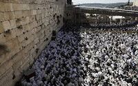
Yerushalayim
This article is incomplete because it is pending further input from participants, or it is a work-in-progress by one author. Please comment on this article's talk page to share your input, comments and questions. Note: To contribute to this article, you may need to seek help from the author(s) of this page. |
Yerushalayim
יְרוּשָׁלַיִם | |
|---|---|
Capital City | |
 | |
| Nickname: The Holy City | |
| Country | Yisrael |
| Founded | c. 3,000-2,800 B.C.E. |
| Seat of Government | 1715 |
| Government | |
| • Type | Strong Mayor-Council Form |
| • Body | City Council |
| • Mayor | Ahron Burgman (RC) |
| • City Council President | TBD (TBD) |
| Population (August 1, 2019) | |
| • Total | 989,508 (metro excluded) |
| • Density | 6,340/km2 (16,400/sq mi) |
| Demonym | Yerushalami |
| Time zone | UTC+2 (WST) |
Yerushalayim, located on a plateau in the Judean Mountains between the Thalassan Ocean and the Great Salt Lake, is one of the oldest cities in the world. It is considered holy to the three major Abrahamic religions—Judaism, Christianity and Azdarin. It is the capital and seat of government of the Kingdom of Yisrael, as well as a major metropolitan urban center. Yerushalayim is the largest city in Yisrael by population, with a total population of nearly 990,000 and a metro population of 1.4 million in 2019. It has an area of only 0.9 square kilometres (0.35 sq mi), making it one of the smallest cities of its size in all of the world.
The Greater Yerushalayim metropolitan economy is an estimated 2020 GDP of $198 billion. Besides serving as the capital city, Yerushalayim also serves as a major inland trade and commerce conduit for Northwestern Scipia. It is the home of a well-regarded ancient, preserved, and tourist-oriented culture.
Etymology
According to the Hebrew Bible, the name "Yerushalayim" (Anglicized: Jerusalem) first appears in Bereshis. The word is a combination of "Hashem Yireh" ("Hashem will see," so named by Avrohom during the Akeidas Yitzchok) and "Shalem," named by Shem, a son of Noach). The Midrash says that in deference to both righteous men, G-d united the two place names into one, yielding Yerushalayim.
History
Geography and climate
Geography
The city is located on an edge of the Judean Mountains plateau in West Scipia. Two mountains comprise the current metropolitan breath of the city - Mount Olivet (sometimes referred to as the "Mount of Olives"; Hebrew: Har HaZeitim) and Mount Tsofim (Hebrew: Har HaTsofim, lit. "Mount of the Watchmen/Guards").
In the time of the Shoftim and early monarchy, Yerushalayim was surrounded by numerous forests, particularly of pine trees, olive groves (see Mount of Olives), and almond trees. However, millennia of urbanization, wood-burning as a form of fuel, destruction from warfare, lack of management, and for other reasons, many of these forests have disappeared or are shadows of their former selves. Since late antiquity and the High Middle Ages when this deforestation hit its peak, farmers in the region outside of the city limits built stone terraces along the slopes to hold back the soil from collapse or mudslides, a physical feature still very prominent across the city's landscape, especially in its hinterlands.
Due to its position, the city receives much less rainfall in the summer months. In the ancient and pre-modern past, this has led to the development of sophisticated water-supply systems, including cisterns, aqueducts (during Latin rule), tunnels, collecting pools, and stone or rock elevated slides at a slant.
Yerushalayim is about 50 miles east of Ashkelon and the Thalassan Ocean. It is about 25 miles south of the Kinneres Sea, and about 60 miles west of Dervaylik. From its perch in the Judean Mountains, it surveys the whole of the verdant and rich Yarden River Valley, seeing into southeastern Sydalon as well as into cities such as Yericho and Chevron. The Great Salt Lake is about 24 miles direct east of the city.
Climate
Yerushalayim has the relatively rare cool-summer Periclean climate (also shared with the mountain city of Beersheva in Yisrael's south), given its high altitude and confluence of eastern Thalassan cold fronts and upwelling. Snowfall occurs 3-6 times a year, and can accumulate.
The coldest month of the year is December, with an average of 38.4 °F, followed by January, with averages 43.7 °F. In contrast, the hottest months are June-August, which average 71.6 °F, though July in particular typically sees a week or two of temperatures north of 90 °F. This is offset by cooler nights and lower humidity.
In the early-to-mid 20th century, the city experienced notable air pollution, due to industrial smoke blown over it by expanding factories in eastern Yisrael as well as from growing vehicular traffic between the 1920s and 1950s. The ancient, narrow streets of the city's Old Quarter and New City were not planned to accommodate such traffic, and Yerushalayim experienced a boom in new automobiles on city streets after 1921. The air pollution became such a nuisance that in 1942, the Sydalene envoy to Yisrael for occupation affairs under the 1941 treaty, Oliver Difesa, Baron Haffa, who had taken up residence in the city as the liaison to the Government of Yisrael, complained in a late 1941 diplomatic cable that the "fog and smoke turns your nose on fire, and...breathing regularly when at a high place...is like inhaling cigarette smoke in one full, complete huff." The Sydalene government threatened additional sanctions unless the Yisraeli postwar peace government acquiesced to its demand to ban automobiles from many streets and completely citywide at least once a week. The caretaker government of Prime Minister Putiel Werther begrudgingly complied, until General David Azoulay repealed the law in 1943 to nationalist applause. Laws established under President Asher Berkowitz in the early 1960s cut air pollution noticeably. Today, air pollution is at about 34% of 1941 levels.