Kassar
This article is incomplete because it is pending further input from participants, or it is a work-in-progress by one author. Please comment on this article's talk page to share your input, comments and questions. Note: To contribute to this article, you may need to seek help from the author(s) of this page. |
Kassar / Sattiapour / Kassar Chancellery Кассар (Narodyn) | |||||||||
|---|---|---|---|---|---|---|---|---|---|
| 1750–1946 | |||||||||
 | |||||||||
| Capital | Baisara | ||||||||
| Common languages | Narodyn (official) Subarnan | ||||||||
| Religion | Episemialist Sotirianity Irfan | ||||||||
| Demonym(s) | Kassari | ||||||||
| Government | Colony within an absolute monarchy (1750–1861) Autonomous governorate within a unitary presidential republic (1861–1946) | ||||||||
| Governor | |||||||||
• 1750–1771 | Chandran Ghani Khan (first) | ||||||||
• 1943–1946 | Yuri Pavlyuk (last) | ||||||||
| Historical era | New Imperialism and Great War | ||||||||
| 30 March 1750 | |||||||||
• Kassari devolution | 9 August 1861 | ||||||||
• Returned to Subarna | 18 April 1946 | ||||||||
| Area | |||||||||
| 1901 | 8,028 km2 (3,100 sq mi) | ||||||||
| Population | |||||||||
• 1901 | 451,627 | ||||||||
| Currency | Narozalic korol | ||||||||
| |||||||||
| Today part of | |||||||||
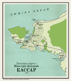
Kassar (Narodyn: Кассар; Kassar), also known as Sattiapour or the Kassar Chancellery (Narodyn: Кассарська канцелярія; Kassars'ka kantselyariya) after 1861 was a protectorate of Narozalica from 1750 to 1946. It consisted of the Kassar Peninsula, where the Subarnan city of Satyapur is located, and was conquered from the Aslamid Empire in 1750. With an official name change to the Kassar Chancellery by Eduard Olsov in 1861 and a shift to being a devolved and autonomous overseas province, Kassar was a prosperous port of Narozalica's overseas empire and facilitated much of its colonial trade. Vladislav Pudovkin and the immediate post-independence government of Subarna facilitated the return of Kassar in 1946 after the Solarian War.

