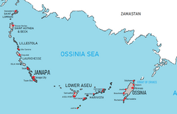
Northern Cantalle Islands
Jump to navigation
Jump to search
Northern Cantalle Islands | |
|---|---|
 Map of the Northern Cantalle Islands | |
| Region | Cantalle Ocean |
| Island States | |
| Area | |
| • Total | 44,364 km2 (17,129 sq mi) |
| Population (2009) | |
| • Total | 23,949,250 |
| • Density | 274.9/km2 (712/sq mi) |
| Demonyms |
|
The Northern Cantalle Islands, often abbreviated as the NCI or known as the Northern Toyanas, are a group of islands in the northeast Cantalle Ocean, forming the Ossinia Sea between them and mainland Euronia. Most of them are part of a long, partially volcanic island arc between the Tayans, which form the northernmost and westernmost islands, and the Josettes, which form the southernmost and easternmost islands. Together, these make up the Northern Cantalle Islands.
History
Geography
Political divisions
Sovereign states
| Name | Population | Island Group | Capital |
|---|---|---|---|
| Isla Ima | 207,000 | Tayans | Isla Ima |
| Janapa | 2,093,000 | Tayans | Janapa City |
| Laurichesse | 516,000 | Tayans | Coquelet |
| Lillestola | 702,000 | Tayans | Lille Centre |
| Lower Aseu | 2,704,800 | Josettes | Aseu Port |
| Marivista | 826,500 | Josettes | Port Carpal |
| Ossinia | 7,233,000 | Josettes | Périnnois |
| Saint Astaba and Beck | 2,231,000 | Tayans | Goose Harbor |
| Saint Lorrain | 616,000 | Tayans | Basseterre |