Flussmund: Difference between revisions
The ©rusader (talk | contribs) m (Edit in categories) |
No edit summary |
||
| Line 12: | Line 12: | ||
| photo3a = HamburgSpeicherstadt.jpg | | photo3a = HamburgSpeicherstadt.jpg | ||
| photo3b = Manhattan_Bridge_2007.jpg | | photo3b = Manhattan_Bridge_2007.jpg | ||
| photo4a = | | photo4a = Frankfurt_2013_-_panoramio_(4).jpg | ||
| size = 270 | | size = 270 | ||
| spacing = 2 | | spacing = 2 | ||
| Line 18: | Line 18: | ||
}} | }} | ||
|imagesize = | |imagesize = | ||
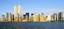
|image_caption = <small>'''Clockwise from top''': Lonasbek skyline with the Intertrade Complex (to the left), St. Catherine's Cathedral, Amelienburg Bridge, Nielsenshafen | |image_caption = <small>'''Clockwise from top''': Lonasbek skyline with the Intertrade Complex (to the left), St. Catherine's Cathedral, Amelienburg Bridge, Nielsenshafen Market, Reeperstadt, Flussmund Market Square with City Hall (left), Flussmund Cathedral (center) and State Citizenry (right)</small> | ||
|image_flag = Flag_of_Hesse.svg | |image_flag = Flag_of_Hesse.svg | ||
|image_shield = Flussmund seal.png|100px | |image_shield = Flussmund seal.png|100px | ||
Revision as of 12:37, 7 April 2022
This article is incomplete because it is pending further input from participants, or it is a work-in-progress by one author. Please comment on this article's talk page to share your input, comments and questions. Note: To contribute to this article, you may need to seek help from the author(s) of this page. |
Flussmund | |
|---|---|
State capital city | |
| Imperial City Municipality of Flussmund Reichsstadtgemeinde Flussmund | |
Clockwise from top: Lonasbek skyline with the Intertrade Complex (to the left), St. Catherine's Cathedral, Amelienburg Bridge, Nielsenshafen Market, Reeperstadt, Flussmund Market Square with City Hall (left), Flussmund Cathedral (center) and State Citizenry (right) | |
| Country | |
| State | Flussmund |
| Government | |
| • Mayor | Henriette Peters (SDP) |
| Area | |
| • State capital city | 409.9 km2 (158.3 sq mi) |
| Elevation | 10 m (27.3 ft) |
| Population (2019) | |
| • State capital city | 4,118,492 |
| • Metro | 5,452,088 |
| Demonym(s) | Flussmunder (m), Flussmundin (f) |
| Time zone | UTC+2 (EST) |
| Postal code | 03 |
| Area code(s) | 165, 247 |
| Vehicle registration | FM |
Flussmund (Hesurian: X), officially the Imperial City Municipality of Flussmund (Hesurian: Reichsstadtgemeinde Flussmund) is the largest city and capital city of the Mascyllary state Free Imperial City of Flussmund (Freie Reichsstadt Flussmund), being one of the two major economic, cultural, and demographic metropoles of the country with Königsreh. The city is organized as a two-city state shared with the city of Dockfurt to the north. Flussmund is the most populous city in Mascylla with a population of 4,118,492 in 2019, and the largest city in Berea which is not a capital. The metropolitan region contains more than 5.4 million people.
Flussmund is the largest city on the River Blaugold, the longest river flowing entirely within Mascylla, and the North Sea. TBD


