Terre-Belle: Difference between revisions
No edit summary |
No edit summary |
||
| Line 129: | Line 129: | ||
The province of Terre-Belle comprises the namesake island of Terre-Belle, Île du Édouard to the east, as well as several thousand islands. The island of Terre-Belle itself is the largest non-continental island in [[Kylaris]], separated from the rest of Asteria Superior by Dumont Bay and the Gulf of Chicadia. | The province of Terre-Belle comprises the namesake island of Terre-Belle, Île du Édouard to the east, as well as several thousand islands. The island of Terre-Belle itself is the largest non-continental island in [[Kylaris]], separated from the rest of Asteria Superior by Dumont Bay and the Gulf of Chicadia. | ||
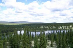
[[File:NLW Table2 tango7174.jpg|thumb|right|250px|The | [[File:NLW Table2 tango7174.jpg|thumb|right|250px|The Occidental Range on Terre-Belle's coastline are the westernmost mountains in the Asterias.]] | ||
There are three major mountain systems in the province; Violet, | There are three major mountain systems in the province; Violet, Occidental, and Imperial ranges. The Violet Range; located in the south easternmost portion of Terre-Belle; is the northernmost section of the Charbagne Mountains and maintains the rolling and eroded characteristics of those seen on the Cassien mainland. The Occidental Range are the westernmost mountains in the Asterias, whose proximity to the Vehemens and Florian Oceans combined with the influence of glaciation has produced fjords and deep valleys. The Imperial Range, located along Terre-Belle’s north coast, are largest range of mountains in the province and are dominated by the presence of ice fields and glaciers. | ||
Terre-Belle is also characterized by large, relatively flat regions. In the northern interior is a large basin of depressed land created by the weight of large ice sheets during the last ice age. This basin is host to thousands of lakes and rivers that ultimately drain into Dumont Bay. In the centremost area of the province is also a vast plateau which is also the site of many large lakes and rivers. | Terre-Belle is also characterized by large, relatively flat regions. In the northern interior is a large basin of depressed land created by the weight of large ice sheets during the last ice age. This basin is host to thousands of lakes and rivers that ultimately drain into Dumont Bay. In the centremost area of the province is also a vast plateau which is also the site of many large lakes and rivers. | ||
Revision as of 14:05, 15 November 2021
This article is incomplete because it is pending further input from participants, or it is a work-in-progress by one author. Please comment on this article's talk page to share your input, comments and questions. Note: To contribute to this article, you may need to seek help from the author(s) of this page. |
Terre-Belle | |
|---|---|
Province | |
| Motto(s): Regnat populus (Solarian) "The people rule" | |
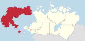
 Map of Cassier with Terre-Belle in red | |
| Country | |
| Capital (and largest city) | Porte-Calme |
| Largest metro | Porte-Calme metropolitan area |
| Confederation | 1 July, 1757 |
| Government | |
| • Premier | [name] |
| • Governor | [name] |
| • Legislature | Provincial Assembly of Terre-Belle |
| Area | |
| • Land | 2,278,492.16 km2 (879,730.74 sq mi) |
| • Rank | 1st |
| Population (2018) | |
| • Total | 519,685 |
| • Rank | 8th |
| • Density | 0.23/km2 (0.6/sq mi) |
| Time zone | UTC+7 to +8 (Florian/Vehemens) |
| Abbreviation | TB |
| Prefix | A, B |
| ISO 3166 code | CA-TB |
| Rankings include all provinces and territories | |
Terre-Belle is the westernmost province in Cassier. It comprises the islands of Terre-Belle, Île du Édouard, and several thousand other smaller islands. As of 2018 Terre-Belle had 518,685 inhabitants, making it the least populated province in Cassier, accounting for only 1.3 percent of Cassier's total population. The majority of its population reside in or within the surrounding metropolitan area of Porte-Calme, which is both the province's capital and largest city. With a geographical area of 2,278,492.16 square kilometres, Terre-Belle is the largest province in terms of geographical area, accounting for roughly 24 percent of Cassier's land area. The province's capital and largest city is Porte-Calme.
Terre-Belle is entirely surrounded by water and has no land borders with any other province or territory. Gaullicans make up the majority of Terre-Belle’s population, however minorities such as Ghailles and indigenous groups such as the Megsig and Borealians also have a noticeable presence in the province.
The recorded history of Terre-Belle began in 1488 following the arrival of explorer Assim Asteris on Île du Édouard. His arrival brought an end to the isolation of the indigenous Asterians and the beginning of Euclean colonization of the New World. Caldian and Ghaillish mariners established small seasonal outposts in the late 15th century, though they were largely abandoned by the mid-16th century. Gaullican explorer Rogerin Dumont bestowed Terre-Belle its name in 1534 following his difficult voyage across the Vehemens Ocean to Asteria Superior, claiming the land for Gaullica. For most of its history, Terre-Belle was administered by the colonial government of Terre-Belle and the Dumont Bay Company, which controlled much of northern Cassier until its incorporation in 1870. Terre-Belle was one of the colonies to confederate into the Domain of Cassier on July 1, 1757, along with Chicadia, New Sylvagne, Upper Cassier, and Lower Cassier. It remained a part of Cassier until 1915, when Terre-Belle voted to return to direct Gaullican rule. As a consequence, it was directly involved in the events of the Great War, having an active role in contrast to Cassier’s neutrality during the conflict. Following Gaullica’s defeat, Terre-Belle was briefly occupied by Rizealand and other Grand Alliance forces until Cassier’s declaration of independence on October 14, 1936.
Etymology
There are two widely accepted theories regarding the etymology of Terre-Belle. The first and most widely accepted of these postulates that the name can be traced back to the first Eucleans; Caldians and Ghailles, shortly after its initial discovery. The records and maps produced by these mariners generally referred to Terre-Belle as "Eilean Bòidheach", meaning "beautiful isle", referencing its geographical beauty or the feeling of relief felt by these sailors after their difficult journeys across the Vehemens Ocean. Rogerin Dumont is known to have brought several Caldians and Ghailles on his first voyage to the Asterias in 1534 as guides, and it is believed that he recorded the direct, though grammatically incorrect, translation of the name from Ghaillish to Gaullican; Terre-Belle.
The second but not as accepted theory proposes that Terre-Belle, instead of referring to the island itself, was chosen by Dumont to honour the reigning monarch and supporter of his voyage; Queen Anne the Financer of Gaullica.
Geography
The province of Terre-Belle comprises the namesake island of Terre-Belle, Île du Édouard to the east, as well as several thousand islands. The island of Terre-Belle itself is the largest non-continental island in Kylaris, separated from the rest of Asteria Superior by Dumont Bay and the Gulf of Chicadia.
There are three major mountain systems in the province; Violet, Occidental, and Imperial ranges. The Violet Range; located in the south easternmost portion of Terre-Belle; is the northernmost section of the Charbagne Mountains and maintains the rolling and eroded characteristics of those seen on the Cassien mainland. The Occidental Range are the westernmost mountains in the Asterias, whose proximity to the Vehemens and Florian Oceans combined with the influence of glaciation has produced fjords and deep valleys. The Imperial Range, located along Terre-Belle’s north coast, are largest range of mountains in the province and are dominated by the presence of ice fields and glaciers.
Terre-Belle is also characterized by large, relatively flat regions. In the northern interior is a large basin of depressed land created by the weight of large ice sheets during the last ice age. This basin is host to thousands of lakes and rivers that ultimately drain into Dumont Bay. In the centremost area of the province is also a vast plateau which is also the site of many large lakes and rivers.
Climate
The climate of Terre-Belle is divided among three different zones. The largest, making up a majority of Terre-Belle’s land, is the subarctic zone. The areas within this zone experience cold, snowy winters and short, cool summers that rarely exceed 20°C, similarily to other subarctic areas found elsewhere in Cassier. The next largest zone is the arctic zone, located in the northernmost regions of the province or on the summits of tall mountain peaks. Areas in this zone experience long and very cold winters and short, cool summers. Encompassing the southernmost portion of Terre-Belle and Île du Édouard is the temperate zone which is characterized by oceanic and continental climates. This zone’s location in lower latitudes and its proximity to warmer ocean water gives this region a milder climate compared to those of the other two climate zones on the island.
Ecology
With the exception of the arctic zone, Terre-Belle's landscape is dominated by large areas of forest and woodland. Taiga and boreal forests, dominated by coniferous trees and other hardy plants, make up the majority of vegetation in the province. Mixed or broadleaf forests are limited to the temperate zone in the south, where more moderate temperatures can support a higher diversity of plant species.
During the last ice age the island of Terre-Belle was completely covered by glaciers and swept clean of life, resulting in very few species that can be considered "native". Similarly, only freshwater-fish capable of surviving seawater swam to the island. The island is home to only several dozen mammal species, with no snakes, raccoons, skunks or porcupines. Terre-Belle is host to an array of plant species' such as Long’s braya (Braya longii) and Fernald’s braya (B. fernaldii), which are unique to the island. Recently, several plants and animals have been introduced to Terre-Belle. Moose, snowshoe hare, Asterian red squirrel, and others, were brought to the island through specific wildlife mandates or by accident.
Demographics
The province of Terre-Belle has a total of 519,685 inhabitants according to the 2018 Cassien Census, making it the least populous province in Cassier and accounting for only 1.3 percent of the national total. At 0.23 persons per square kilometre, Terre-Belle is the least densely populated of Cassier's provinces. The majority of its population live in the southernmost portions of the island of Terre-Belle or on Île du Édouard, where the milder climate is more accomidating for agriculture and habitation. Terre-Belle's population is mostly urbanized, with 62 percent of its population living in centres with populations greater than 6 thousand inhabitants. With a population of 108 thousand people, its capital of Porte-Calme is the only city with a population that exceeds 30 thousand inhabitants.
| Largest urban centers by population | |||||||
|---|---|---|---|---|---|---|---|
| Rank | Town | Population (2018) | |||||
| 1 | Porte-Calme | 108,000 | |||||
| 2 | Tebouque | 27,000 | |||||
| 3 | Saint-Pierre | 24,000 | |||||
| 4 | Saint-Espirit | 21,000 | |||||
| 5 | Dierre | 20,000 | |||||
| 6 | Port-Dubois | 17,000 | |||||
| 7 | La Passage | 13,000 | |||||
| 8 | Pointe de l'Est | 11,000 | |||||
| 9 | Jeanville | 11,000 | |||||
| 10 | Val Moyenne | 10,000 | |||||

