Kasaria (Kylaris)
Merchant Republic of Kasaria Jamhuriyar Fatauci na Kasarriya Handelsrepublik Kasaria | |
|---|---|
| Motto: "Allah Ya Kiyaye Mu (May God Preserve Us)." | |
| Anthem: Zuwa Teku (Ode Das Meer) | |
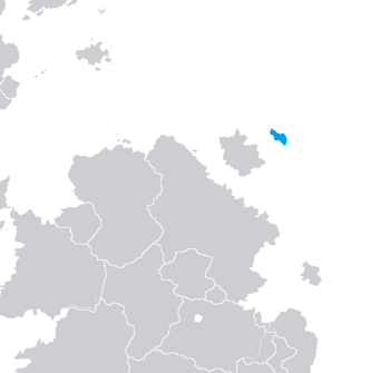
 The Location of Kasaria in Coius | |
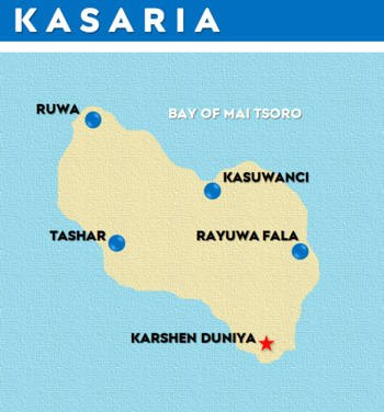
 Political Map of Kasaria | |
| Capital | Karshen Duniya (Meerheim) |
| Official languages | Kasari Weranian |
| Recognised national languages | Estmerish Gaullican |
| Ethnic groups | |
| Demonym(s) | Kasari Kasarian |
| Government | Unitary Constitutional Republic |
• President | Walter Eveslage |
• Vice President | Kyauta S. Musa |
| Legislature | Kasa Dokokin (Volksvertretung) |
| Babban Gida (Oberhaus) | |
| Karamar Gida (Unterhaus) | |
| History | |
• TBD | TBD |
• TBD | TBD |
• TBD | TBD |
• TBD | TBD |
• TBD | TBD |
• TBD | TBD |
| Area | |
• Total | 26,467.84 km2 (10,219.29 sq mi) |
| Population | |
• 2020 census | 9,963,00 |
• Density | 376.41/km2 (974.9/sq mi) |
| GDP (PPP) | 2020 estimate |
• Total | $511.05 Billion |
• Per capita | $51,295.25 |
| GDP (nominal) | 2020 estimate |
• Total | $379.65 Billion |
• Per capita | $38,106.34 |
| Currency | Kasari Dala (Ɒ) (KSD) |
| Date format | mm-dd-yy |
| Driving side | right |
Kasaria (/xɑzɑriə/ kuh-SAAR-ee-uh; Kasari: Kasarriya), officially the Merchant Republic of Kasaria (Kasari: Jamhuriyar Fatauci na Kasarriya) is a prospective sovereign island country in Coius, currently being built for the region of Kylaris. It is located to the extreme northeast of the continent in the Vehemens Ocean to the south of the Florian Sea, making it a vital commercial trade port and transportation hub for Transvehemens travel and trade off the coast of Bahia. It is near the halfway point between Geatland in Euclea and St. Robert's and Fleming. The capital, largest city and principal port of Kasaria is Karshen Duniya, which dominates the island nation as a primate city.
The island enjoys a subtropical climate, with mild winters and warm, humid summers; currents from the Florian Sea coming down from the north provide stabilizing oceanic effects, particularly during the summer months. The population of just under ten million is concentrated around the coast, with much of the population residing near the country's famed deepwater ports. The relative lack of elevation makes the country prone to tsunamis owing to its proximity to an active tectonic boundary. After the 1953 Karkashin earthquake led to significant damage and loss of life along the island's eastern seaboard, a series of coastal defenses were constructed to help mitigate the risk of a repeated tragedy.
Human migration to Kasaria is thought to have occurred roughly 40,000 years ago; archaeological evidence points to seafaring hunter-gatherers traversing the Straits of Bahia to reach the island. The native Tsibirin peoples began to establish religious shrines on the island, with settlements springing up around them over the course of several hundred years. The arrival of Weranian explorers in DATE HERE [XXXX] would put an end to the budding Kasari Kingdom, leading to years of segregation and serfdom for the native population. Upon the withdrawal of Werania and the island's independence in DATE HERE [XXXX], a series of constitutional reforms brought legislative equality to the Kasari minority, helping to institute a liberal democracy on the island. After the emigration of Weranian colonists following Kasari independence, the island's population demographics stabilized with a near equal split between descendants of Weranian colonists and the native Tsibirin peoples.

