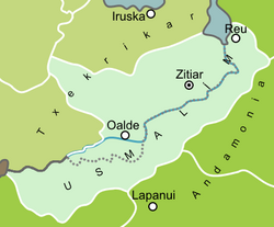
Usmalím
Usmalím | |
|---|---|
Prefecture of Txekrikar | |
 Map of the Usmalím; pre-reunification division shown along dotted line | |
| Nation | Txekrikar |
| Capital | Zitiar |
The Usmalím is a region and prefecture in southeast Txekrikar. It is Txekrikar's largest administrative area, covering almost a third of the nation's landmass, at 44,353 square kilometres. Its administrative seat is Zitiar. It borders Andamonia in the east and has a border just eight kilometres long with the Aztec National League in the west; it also borders the prefectures of Mugan and Barre in the west and Arrain in the north.
Since the late nineteenth century, the Usmalím has regularly been a theatre of war. It was the scene of the Baira Debacle in the 1870s, and in the Great Astyrian War was occupied by Andamonia. In the 1930s, the Trophy Wars restored Txekri governance over the western half of the region, but it was not until the War of the Eastern Velar, in 2014, that Trellin occupied the eastern half, formerly administrated from Reu (Rehahu) as an Andamonian province. It was placed under transitional government and reunified with Txekrikar in February 2016.
Name
The name 'Usmalím' is composed of elements from the Sa'sseban and Andamonian languages. Usem is the Sa'sseban word for salt, and historically the region was known in Txekrikar as the Parúki Usemma ('Source of Salt'). The suffix -lím in Andamonian denotes a remote or border territory, as seen in the Andamonian provincial name Ahaltlím. The Usmalím, therefore, was the 'Border of Salt', or 'Salt March'.
Prior to reunification, in 2016, the two halves of the region were known as the Txekri Usmalím and Andamonian Usmalím, respectively.
History
Geography
As its toponymy suggests, the Usmalím is characterised by a vast area of wetland along both banks of its chief river, the Baira. During and following the monsoon season, the river, which normally lies at the bottom of a broad, muddy gulch, floods spectacularly and inundates several thousand square kilometres along its middle to lower course, particularly between Oalde and Zitiar. A rich and fertile marshland results from this cyclical flooding, and the drying of salt in reclaimed pans was a major industry for the province in the medieval period.
