Geography of Zhenia: Difference between revisions
(Created page with "{{Infobox country geography | name = Zhenia (진국) | image name = | image size = | image caption = | image alt...") |
No edit summary |
||
| (17 intermediate revisions by the same user not shown) | |||
| Line 1: | Line 1: | ||
{{Infobox country geography | {{Infobox country geography | ||
| name | | name = Zhenia | ||
| image name | | image name = | ||
| image size = | | image size = | ||
| image caption = | | image caption = | ||
| Line 12: | Line 12: | ||
| coordinates = <!-- Use {{Coord}} --> | | coordinates = <!-- Use {{Coord}} --> | ||
| area ranking = | | area ranking = | ||
| km area = 5, | | km area = 5,358,285.1 | ||
| miles area = | | miles area = auto | ||
| percent land = | | percent land = 98.33 | ||
| percent water = | | percent water = 1.67 | ||
| km coastline = | | km coastline = | ||
| miles coastline = | | miles coastline = | ||
| borders = | | borders = [[Yinguo]] | ||
| highest point = [[Mount | | highest point = [[Mount Kanchenlunga]] <br> 8,782.8 m | ||
| lowest point = [[Lake Sagyeong]] <br> -87 m | | lowest point = [[Lake Sagyeong]] <br> -87 m | ||
| longest river = [[Taimir River]] <br> 5,429 km | | longest river = [[Taimir River]] <br> 5,429 km | ||
| Line 26: | Line 26: | ||
| terrain = Mountains in center-west and southwest and along the [[Danguk Peninsula]], plains in the center, hills in the south | | terrain = Mountains in center-west and southwest and along the [[Danguk Peninsula]], plains in the center, hills in the south | ||
| natural resources = arable land, coal, iron ore, bauxite, uranium, petroleum, natural gas, rare-earth minerals, timber | | natural resources = arable land, coal, iron ore, bauxite, uranium, petroleum, natural gas, rare-earth minerals, timber | ||
| natural hazards | | natural hazards = earthquakes, floods, forest fires, typhoons, landslides | ||
| environmental issues = air pollution, water pollution, desertification, deforestation, soil erosion | | environmental issues = air pollution, water pollution, desertification, deforestation, soil erosion | ||
}} | }} | ||
'''Zhenia''' is a nation located on the eastern coasts of the continent of [[Tarsis]] in [[Themis|Themys]], primarily facing the [[Hanmaric Ocean]]. | '''Zhenia''' is a nation located on the eastern coasts of the continent of [[Tarsis]] in [[Themis|Themys]], primarily facing the [[Hanmaric Ocean]]. Zhenian geography shows great physical diversity, ranging from fertile lowlands and foothills found along most of the [[Golden Arc]] area, to the semi-arid basins and mountains to the west. Both due to terrain and climate, a vast majority of the nation's population and agricultural potential are focused in the east, particularly near the [[Gulf of Danguk]]. | ||
While Zhenia's northern and southern borders are each defined by the [[Baekryong River|Baekryong]] and [[Chang River|Chang Rivers]] respectively, Zhenia's geography is primarily characterized by the existence of the [[Cheonsan Mountains|Cheonsan]] and [[Jinsan Mountains|Mountains]], which act as physical boundaries separating western and northern Zhenia from the remainder of the nation respectively. Arid plains, scrubland, plateaus and rocky deserts dominate the landscape west and north of such mountains, while the Taimir River Basin occupies much of what is central Zhenia. The [[Bukdu Mountains]], with the [[Musudan Highlands]] at its northern end, runs through the length of the mostly mountainous Danguk Peninsula, accompanied by smaller, secondary mountain ranges. Several rivers, including the [[Taimir River|Taimir]] and [[Danbon River|Danbon]] rivers, traverse through most of the nation. Its geography has considerably influenced its concentration of urban and metropolitan areas near the [[Golden Arc]] region. | |||
==Tectonics== | ==Tectonics== | ||
==Geology== | |||
==Physical regions== | ==Physical regions== | ||
| Line 39: | Line 41: | ||
===General characteristics=== | ===General characteristics=== | ||
=== | {{main|Regional Classification of Zhenia}} | ||
===Eastern Zhenia (Danguk Peninsula)=== | |||
{{main|Danguk Peninsula|Haedong Islands}} | |||
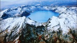
[[File:Mount Jinak, southern view.jpg|250px|thumb|right|Mount Jinak, historically regarded as the 'holy mountain', is the highest mountain in the Danguk Peninsula.]] | |||
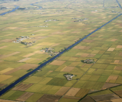
[[File:Chungmu Province Alluvial Plains.png|250px|thumb|right|Alluvial plains in the Danguk Peninsula are prominent in the west coast of the peninsula.]] | |||
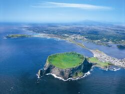
[[File:Volcanic Haedong Islands.jpg|250px|thumb|right|The Haedong Islands were formed by years of volcanic activity, some of which are still active to this day.]] | |||
Although its definition has expanded in recent years to include the [[Haedong Islands]] as well, Eastern Zhenia still often refers to the Danguk Peninsula and surrounding islands, as clarified by the [[Constitution of the Republic of Zhenia|Constitution]] in 1979. Surrounded by the [[Gulf of Danguk]], the [[Strait of Zhenia]] and the [[Hanmaric Ocean]], eastern Zhenia is home to a relatively high concentration of Zhenian inhabitants due to adequately temperate climate and flat terrain formed by alluvial plains, particularly in the coasts facing the Gulf of Danguk. | |||
The [[Bukdu Mountains]] form the primary backbone of the peninsula, running from the [[Musudan Highlands]] to the southeastern edges of the peninsula, ending at [[Toham Mountain]]. Due to the fact that the Bukdu Mountains are somewhat slanted to the east coasts rather than the west coasts of the peninsula, it is traditionally accepted that the eastern half of the Danguk Peninsula is on average higher in elevation than than the west, which has been clarified with the fact that more rivers in the peninsula empty at the Gulf of Danguk rather than the East Zhenian Sea. Influenced by the presence of the Bukdu Mountains, a considerable part of western Danguk Peninsula consists of alluvial plains, with the exception of occasional mountain ranges branching from the Bukdu Mountains. Western Danguk Peninsula is also home to the second and third-largest freshwater lakes in the nation, [[Lake Jungsan]] and [[Lake Payang]] respectively. The eastern half of the peninsula, in contrast, tends to be more mountainous than the west, with smaller pockets of alluvial flatland towards the northeastern parts of the peninsula. | |||
The Haedong Islands are a series of islands formed as a result of centuries volcanic activity at a tectonic hot spot around 2.4 million years ago during the {{wp|Cenozoic Era}}, just east of the Danguk Peninsula. With the bedrock of the islands consisting primarily of lava and later sediments, it has been widely regarded as some of the most fertile places in Zhenia. While the western portion of the Haedong Islands has been inhabited by [[Haedong Zhenian|Haedong Zhenians]] since prehistoric times, a considerable part of the eastern islands remained uncultivated until the 18th century, resulting in the unique ecology of the region. | |||
===Northern Zhenia=== | |||
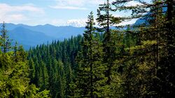
[[File:Northern Zhenia taiga.jpg|250px|thumb|right|Coniferous forests cover a considerable amount of terrain in northern Zhenia.]] | |||
{{ | Northern Zhenia stretches from the cold coasts of [[Bukhae Province]] to the northeastern branches of the [[Cheonsan Mountains]] and the [[Jinsan Mountains]], and from Zhenia's northern borders to the [[Weisu River]]. A considerable part of northern Zhenia is mountainous and covered in forests, with the Jinsan Mountains forming a natural border between central Zhenia and the cold, semi-arid plains extending to the north. | ||
The physical boundary between northern and western Zhenia is formed by the existence of the Cheonsan Mountains, which run from north to south separating eastern and central Tarsis. Extending north, south and east from the [[Musan Plateau]] in its center, land descends around the mountains like a terrace, often involving stark, somewhat discontinued contrasts in elevation. With an average elevation of over 3,000 meters, many of the nation's highest points, including [[Mount Kanchenlunga]] at 8,782.8 meters, are located along the Cheonsan Mountains. It is the primary cause of the {{wp|rain shadow}} in western Zhenia, resulting in start contrasts in average annual precipitation between central and western Zhenia, while its glaciers serve as the origins of many of the nation's longest rivers, including the Taimir and Chang Rivers. | |||
In contrast to northwestern Zhenia, a considerable part of northeastern Zhenia consist of the [[Northeast Zhenia Plain]], which extend from the Jinsan Mountains to Zhenia's northern border in the Baekryong River, with the exception of the mountainous [[Yeonhaeju Pennisula]] in the nation's northeastern coast. The terrain throughout the Northeast Zhenia Plain vary from steppes towards the west, coniferous forests in the south near the Jinsan Mountains and flatland towards the north and east. The [[Manliheo Mountains]], extending east and west from the Musudan Highlands, separate the Danguk Peninsula and northeastern Zhenia. With adequate climate and terrain, most of the population of northern Zhenia are concentrated in the northeast. | |||
===Central Zhenia=== | |||
[[File:Central Zhenian Plain, Imhae Province.jpg|250px|thumb|right|The Central Zhenian Plains cover much of central Zhenia, stretching almost directly from the Cheonsan Mountains to the Gulf of Danguk.]] | |||
[[File:Taimir River Delta Satellite View.jpg|250px|thumb|right|Tracts of the Taimir River, the longest river in the nation, near its delta mark the geographic boundary between central and southern Zhenia, culminating in the Taimir River Delta around the Gulf of Danguk.]] | |||
Central Zhenia comprises of the area between the Cheonsan Mountain region and the Gulf of Danguk, between the [[Taimir River]] and the [[Weisu River]]. With the exception of the [[Yangzhu Mountains]] extending from the Cheonsan Mountains at its northwest and other smaller mountain ranges, most of central Zhenia is covered by the [[Central Zhenian Plains]], a broad expanse of alluvial and flood plains that are primarily a part of the [[Taimir River#Basin|Taimir River Basin]]. Central Zhenia is therefore home to a majority of Zhenia's arable land. Few major mountains are observed in the region the most notable being [[Osong Mountain]] in the border between [[Imhae Province|Imhae]] and [[Namhwa Province|Namhwa provinces]]. | |||
With most of the macroregion being a part of the Taimir River basin and its tributaries, there are steep drops in elevation as the Cheonsan and Yangzhu mountains give way to the Central Zhenian Plains, resulting in multiple alluvial fans linking the plains and the mountains. W | |||
===Southern Zhenia=== | |||
[[File:Southern Zhenia Karst landforms.jpg|250px|thumb|right|Limestone karst landscape observed along the tributaries of the Chang River, in Taehwa Province.]] | |||
Southern Zhenia is a macroregion comprising of the area between the Taimir River and the [[Chang River]], which in hand forms the nation's southern border with [[Yinguo]]. Mountains fan out from the southern branches of the Cheonsan Mountains, forming the southern end of the Taimir River watershed. The Taehwa Plateau, a densely cultivated region with an average height of around 900 meters (3,000 ft), marks the end of the extension of the Cheonsan Mountains. The plateau is famous for its limestone {{wp|karst}} landscape. | |||
The [[Balhae Peninsula]] extends to the east into the Gulf of Danguk after the Taehwa Plateau subsides. The Balhaeryeong Ranges form the backbone of the peninsula, somewhat mirroring that of the Danguk Peninsula. The Balhaeryeong Ranges of the peninsula are separated from the Jungmun Mountains, a southeastern branch of the Cheonsan Mountains, via the [[Haeha Pass]]. With alluvial plains stretching across the northern half of the peninsula and hills dotting its southern half, almost the entirety of the Balhae Peninsula is arable in nature, allowing it to be home to some of the most heavily populated regions in the nation. | |||
The [[Chang River#Basin|Chang River basin]] is primarily surrounded by mountains, with present-day Zhenian territory primarily spanning over the northern half of the basin and the remainder belonging to Yinguo today. The alluvial plains stretching from the midstream of the Chang River to its delta are primarily covered in forests. The [[Jungmun Mountains]], branching out from the Cheonsan Mountains, act as the watershed between the Taimir and Chang Rivers, sealing off the nation's southern provinces from the Central Zhenian Plain. | |||
===Western Zhenia=== | |||
[[File:Daeseo Desert, Heuksu Province.jpg|250px|thumb|right|The Daeseo Desert, the largest desert in the nation.]] | |||
Western Zhenia is a macroregion spanning all of what's west of the watershed created by the Cheonsan Mountains, which are home to the highest mountains in the nation. The western slope of the Cheonsan Mountains give way to the [[Haetan Basin]], which contains the [[Daeseo Desert]], the largest desert in the nation. [[Lake Sagyeong]] located in [[Dragon Valley]], the lowest point in Zhenia at -87 meters, is in the northern parts of Sahaetan Basin. Enclosed by the span of the Cheonsan Mountains running northeast to southeast and the [[Saghan Mountains]] to the west, arid regions of the Daeseo Desert receive the smallest amounts of precipitation in the nation as a result of the rain shadow effect. Also being home to the highest recorded temperatures in Zhenian history at 48.9 C, the Daeseo Desert is regarded both as one of the hottest and driest places in the nation. | |||
===Extreme Points=== | |||
==Climate== | ==Climate== | ||
[[File:Zhenia 1x Koppen climate map.png|250px|thumb|right|{{wp|Koppen climate|Koppen climate map}} of Zhenia.]] | [[File:Zhenia 1x Koppen climate map.png|250px|thumb|right|{{wp|Koppen climate|Koppen climate map}} of Zhenia.]] | ||
Zhenia is home to a highly diverse climate, due to tremendous differences in latitude, longitude and altitude throughout its territory. Spanning between the latitude lines of 20.8° and 52.6° N, Zhenia's climate spectrum runs from hot in the south to cold in the northeast and humid in the east along the coastline to dry in the west, resulting in a climate that ranges from {{wp|tropical climate|tropical}} in the south, {{wp|subarctic climate|subarctic}} in the northeast and {{wp|desert climate|desert}} in the west. Polar and alpine microclimates are also observed in some pockets of the Cheonsan Mountains, as well as in the peaks of the Saghan and Jinsan Mountains. Climate in much of Zhenia is influenced by seasonal winds and monsoons, bringing in a yearly oscillatory cycle of {{wp|dry season|dry seasons}} and {{wp|wet monsoons}}, in which a bulk of annual precipitation is highly concentrated in certain months of the year. Warm and moist air from the Hanmaric Ocean results in high precipitation and typhoons during the summer season, while the cold and dry continental air from the north dominates the winter season with cold weather and far less precipitation. | |||
While absolute amounts of concentrations vary drastically from region to region, with arid regions such as the Haetan Desert receiving an average of 25 mm of precipitation each year while southern regions of the Balhae Province receive an average of 2,600 mm of precipitation of each year, precipitation is primarily focused in the summer seasons due to seasonal wind activity. Hence, high deviations in average annual precipitation by region are observed: the average precipitation in eastern Zhenia is around 1,500 mm per year, while western Zhenia on average receives 240 mm of precipitation each year. | |||
In recent years, however, {{wp|climate change}} has played a prominent role in changing temperature and precipitation patterns in the region, resulting in more extreme weather conditions to happen more frequently and intensely than before. Climate change has been pointed as the primary reason behind the spike in {{wp|forest fire|forest fires}} and {{wp|storm weather}} in eastern and northern Zhenia. Changing precipitation patterns has also resulted in extensive {{wp|desertification}} in western Zhenia, with ever-diminishing steppe areas and often resulting in more {{wp|dust storm|dust storms}} in central and eastern Zhenia. | |||
==Natural disasters== | ==Natural disasters== | ||
===Earthquakes=== | |||
===Volcanic activity=== | |||
Despite its location near active plate boundaries, Zhenia is home to only a handful of active volcanoes that have been active in the past 300 years, the most notable one being [[Mount Honghwa]] in the Haedong Islands. While there have been no life-threatening eruptions within the past 100 years due to the distance of active volcanoes from major populated areas, the most recent major eruption of an active volcano in Zhenia occurred in 1987, during the [[1987 eruption of Mount Honghwa|eruption of Mount Honghwa]]. The [[Ministry of the Interior (Zhenia)|Ministry of the Interior]], in tandem with the [[Ministry of the Environment (Zhenia)|Ministry of the Environment]], has been overseeing volcanic activities of both active and dormant volcanoes throughout the nation since 1974, while all signs of volcanic activity was formally included into the nation's emergency alert network since 1995. | |||
===Typhoons=== | |||
In much of mainland Zhenia and the Danguk Peninsula, a bulk of the annual precipitation is focused in the summer seasons, a considerable portion of which often comes at the form of {{wp|typhoon|typhoons}}, which originate in the West Hanmaric Ocean and make their way westward before turning clockwise to the north to the East Zhenian Sea. While Central and Southern Zhenia tend to be more affected by typhoons in June and July, more typhoons tend to pass through the Danguk Peninsula and the Haedong Islands in August and September due to seasonal variations in wind speeds. | |||
In theory, almost all of Zhenia's coastline can be at risk of typhoons; however, while most typhoons normally affected mainland Zhenia and the areas surrounding the Gulf of Danguk, recent trends since the late 2000s have seen increased frequency of typhoons making way further northeast, increasing the risks of flooding and significant property damage in the area. There have been increased concerns regarding the rise of surface temperature in the West Hanmaric Ocean, as well as varying patterns of temperature oscillation in the Hanmaric Ocean in general, in fear that such factors are contributing to stronger typhoons. | |||
===Flooding and droughts=== | |||
===Desertification=== | |||
==Human geography== | ==Human geography== | ||
===Population distribution=== | ===Population distribution=== | ||
{{main|Demographics of Zhenia}} | |||
[[File:Zhenia Total Population Distribution Map 2020.png|250px|thumb|right|A map of Zhenia's total population distribution, with darker colors indicating higher concentrations of population. Higher population around the Golden Arc region are observed.]] | |||
Population-wise, Zhenia is relatively densely populated, with around 111.6 people per km2. Much of its population, however, generally follows the distribution of arable land, as it is clarified by the fact that around 96% of the nation's entire population lives east of the [[Bukju-Ariul-Munsan Line]], with the area east of the line accounting for almost all of the nation's arable land. Specifically, over half of the Zhenian population lives in the [[Golden Arc]] region around the [[Gulf of Danguk]], spanning from [[Balhae Province|Balhae]] to [[Namhae Province]], despite only accounting for around 24% of the nation's total land area. In contrast, Zhenia is scarcely populated towards its west and north, primarily due to its relatively harsh terrain and climate. [[Heuksu Province|Heusku]] and [[Shingang Province|Shingang Provinces]], despite accounting for 18% of the nation's entire land area, are together only home to around 1.7% of the nation's population. Some of the most densely populated areas, including the [[Taimir Delta megalopolis|Taimir River Delta]], [[Central Danguk Peninsula megalopolis|Central Danguk Peninsula]] and the [[Western Gulf|Western Gulf megalopolis]] regions, have developed into {{wp|megalopolis|megalopolises}}, covering vast urban areas with high population density. | |||
===Ethnic groups=== | ===Ethnic groups=== | ||
===Administrative | ===Administrative geography=== | ||
{{main|Administrative | {{main|Administrative divisions of Zhenia}} | ||
===Land use=== | ===Land use=== | ||
{{main|Land use in Zhenia}} | |||
===Territory=== | |||
==Environment== | ==Environment== | ||
Latest revision as of 06:45, 12 April 2020
 | |
| Continent | Tarsis |
|---|---|
| Region | Themis |
| Area | |
| • Total | 5,358,285.1 km2 (2,068,845.4 sq mi) |
| • Land | 98.33% |
| • Water | 1.67% |
| Borders | Yinguo |
| Highest point | Mount Kanchenlunga 8,782.8 m |
| Lowest point | Lake Sagyeong -87 m |
| Longest river | Taimir River 5,429 km |
| Largest lake | Lake Jinsa 6,507.3 km2 |
| Climate | Generally temperate and continental climate, arid/semi-arid in west, alpine tundra in the central-western mountains; monsoon-influenced temperate climate in the central and east coasts, subtropical in the south |
| Terrain | Mountains in center-west and southwest and along the Danguk Peninsula, plains in the center, hills in the south |
| Natural Resources | arable land, coal, iron ore, bauxite, uranium, petroleum, natural gas, rare-earth minerals, timber |
| Natural Hazards | earthquakes, floods, forest fires, typhoons, landslides |
| Environmental Issues | air pollution, water pollution, desertification, deforestation, soil erosion |
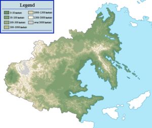
Zhenia is a nation located on the eastern coasts of the continent of Tarsis in Themys, primarily facing the Hanmaric Ocean. Zhenian geography shows great physical diversity, ranging from fertile lowlands and foothills found along most of the Golden Arc area, to the semi-arid basins and mountains to the west. Both due to terrain and climate, a vast majority of the nation's population and agricultural potential are focused in the east, particularly near the Gulf of Danguk.
While Zhenia's northern and southern borders are each defined by the Baekryong and Chang Rivers respectively, Zhenia's geography is primarily characterized by the existence of the Cheonsan and Mountains, which act as physical boundaries separating western and northern Zhenia from the remainder of the nation respectively. Arid plains, scrubland, plateaus and rocky deserts dominate the landscape west and north of such mountains, while the Taimir River Basin occupies much of what is central Zhenia. The Bukdu Mountains, with the Musudan Highlands at its northern end, runs through the length of the mostly mountainous Danguk Peninsula, accompanied by smaller, secondary mountain ranges. Several rivers, including the Taimir and Danbon rivers, traverse through most of the nation. Its geography has considerably influenced its concentration of urban and metropolitan areas near the Golden Arc region.
Tectonics
Geology
Physical regions
General characteristics
Eastern Zhenia (Danguk Peninsula)
Although its definition has expanded in recent years to include the Haedong Islands as well, Eastern Zhenia still often refers to the Danguk Peninsula and surrounding islands, as clarified by the Constitution in 1979. Surrounded by the Gulf of Danguk, the Strait of Zhenia and the Hanmaric Ocean, eastern Zhenia is home to a relatively high concentration of Zhenian inhabitants due to adequately temperate climate and flat terrain formed by alluvial plains, particularly in the coasts facing the Gulf of Danguk.
The Bukdu Mountains form the primary backbone of the peninsula, running from the Musudan Highlands to the southeastern edges of the peninsula, ending at Toham Mountain. Due to the fact that the Bukdu Mountains are somewhat slanted to the east coasts rather than the west coasts of the peninsula, it is traditionally accepted that the eastern half of the Danguk Peninsula is on average higher in elevation than than the west, which has been clarified with the fact that more rivers in the peninsula empty at the Gulf of Danguk rather than the East Zhenian Sea. Influenced by the presence of the Bukdu Mountains, a considerable part of western Danguk Peninsula consists of alluvial plains, with the exception of occasional mountain ranges branching from the Bukdu Mountains. Western Danguk Peninsula is also home to the second and third-largest freshwater lakes in the nation, Lake Jungsan and Lake Payang respectively. The eastern half of the peninsula, in contrast, tends to be more mountainous than the west, with smaller pockets of alluvial flatland towards the northeastern parts of the peninsula.
The Haedong Islands are a series of islands formed as a result of centuries volcanic activity at a tectonic hot spot around 2.4 million years ago during the Cenozoic Era, just east of the Danguk Peninsula. With the bedrock of the islands consisting primarily of lava and later sediments, it has been widely regarded as some of the most fertile places in Zhenia. While the western portion of the Haedong Islands has been inhabited by Haedong Zhenians since prehistoric times, a considerable part of the eastern islands remained uncultivated until the 18th century, resulting in the unique ecology of the region.
Northern Zhenia
Northern Zhenia stretches from the cold coasts of Bukhae Province to the northeastern branches of the Cheonsan Mountains and the Jinsan Mountains, and from Zhenia's northern borders to the Weisu River. A considerable part of northern Zhenia is mountainous and covered in forests, with the Jinsan Mountains forming a natural border between central Zhenia and the cold, semi-arid plains extending to the north.
The physical boundary between northern and western Zhenia is formed by the existence of the Cheonsan Mountains, which run from north to south separating eastern and central Tarsis. Extending north, south and east from the Musan Plateau in its center, land descends around the mountains like a terrace, often involving stark, somewhat discontinued contrasts in elevation. With an average elevation of over 3,000 meters, many of the nation's highest points, including Mount Kanchenlunga at 8,782.8 meters, are located along the Cheonsan Mountains. It is the primary cause of the rain shadow in western Zhenia, resulting in start contrasts in average annual precipitation between central and western Zhenia, while its glaciers serve as the origins of many of the nation's longest rivers, including the Taimir and Chang Rivers.
In contrast to northwestern Zhenia, a considerable part of northeastern Zhenia consist of the Northeast Zhenia Plain, which extend from the Jinsan Mountains to Zhenia's northern border in the Baekryong River, with the exception of the mountainous Yeonhaeju Pennisula in the nation's northeastern coast. The terrain throughout the Northeast Zhenia Plain vary from steppes towards the west, coniferous forests in the south near the Jinsan Mountains and flatland towards the north and east. The Manliheo Mountains, extending east and west from the Musudan Highlands, separate the Danguk Peninsula and northeastern Zhenia. With adequate climate and terrain, most of the population of northern Zhenia are concentrated in the northeast.
Central Zhenia
Central Zhenia comprises of the area between the Cheonsan Mountain region and the Gulf of Danguk, between the Taimir River and the Weisu River. With the exception of the Yangzhu Mountains extending from the Cheonsan Mountains at its northwest and other smaller mountain ranges, most of central Zhenia is covered by the Central Zhenian Plains, a broad expanse of alluvial and flood plains that are primarily a part of the Taimir River Basin. Central Zhenia is therefore home to a majority of Zhenia's arable land. Few major mountains are observed in the region the most notable being Osong Mountain in the border between Imhae and Namhwa provinces.
With most of the macroregion being a part of the Taimir River basin and its tributaries, there are steep drops in elevation as the Cheonsan and Yangzhu mountains give way to the Central Zhenian Plains, resulting in multiple alluvial fans linking the plains and the mountains. W
Southern Zhenia
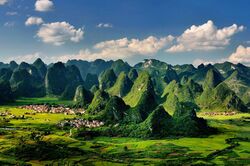
Southern Zhenia is a macroregion comprising of the area between the Taimir River and the Chang River, which in hand forms the nation's southern border with Yinguo. Mountains fan out from the southern branches of the Cheonsan Mountains, forming the southern end of the Taimir River watershed. The Taehwa Plateau, a densely cultivated region with an average height of around 900 meters (3,000 ft), marks the end of the extension of the Cheonsan Mountains. The plateau is famous for its limestone karst landscape.
The Balhae Peninsula extends to the east into the Gulf of Danguk after the Taehwa Plateau subsides. The Balhaeryeong Ranges form the backbone of the peninsula, somewhat mirroring that of the Danguk Peninsula. The Balhaeryeong Ranges of the peninsula are separated from the Jungmun Mountains, a southeastern branch of the Cheonsan Mountains, via the Haeha Pass. With alluvial plains stretching across the northern half of the peninsula and hills dotting its southern half, almost the entirety of the Balhae Peninsula is arable in nature, allowing it to be home to some of the most heavily populated regions in the nation.
The Chang River basin is primarily surrounded by mountains, with present-day Zhenian territory primarily spanning over the northern half of the basin and the remainder belonging to Yinguo today. The alluvial plains stretching from the midstream of the Chang River to its delta are primarily covered in forests. The Jungmun Mountains, branching out from the Cheonsan Mountains, act as the watershed between the Taimir and Chang Rivers, sealing off the nation's southern provinces from the Central Zhenian Plain.
Western Zhenia
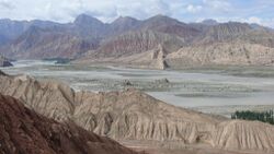
Western Zhenia is a macroregion spanning all of what's west of the watershed created by the Cheonsan Mountains, which are home to the highest mountains in the nation. The western slope of the Cheonsan Mountains give way to the Haetan Basin, which contains the Daeseo Desert, the largest desert in the nation. Lake Sagyeong located in Dragon Valley, the lowest point in Zhenia at -87 meters, is in the northern parts of Sahaetan Basin. Enclosed by the span of the Cheonsan Mountains running northeast to southeast and the Saghan Mountains to the west, arid regions of the Daeseo Desert receive the smallest amounts of precipitation in the nation as a result of the rain shadow effect. Also being home to the highest recorded temperatures in Zhenian history at 48.9 C, the Daeseo Desert is regarded both as one of the hottest and driest places in the nation.
Extreme Points
Climate

Zhenia is home to a highly diverse climate, due to tremendous differences in latitude, longitude and altitude throughout its territory. Spanning between the latitude lines of 20.8° and 52.6° N, Zhenia's climate spectrum runs from hot in the south to cold in the northeast and humid in the east along the coastline to dry in the west, resulting in a climate that ranges from tropical in the south, subarctic in the northeast and desert in the west. Polar and alpine microclimates are also observed in some pockets of the Cheonsan Mountains, as well as in the peaks of the Saghan and Jinsan Mountains. Climate in much of Zhenia is influenced by seasonal winds and monsoons, bringing in a yearly oscillatory cycle of dry seasons and wet monsoons, in which a bulk of annual precipitation is highly concentrated in certain months of the year. Warm and moist air from the Hanmaric Ocean results in high precipitation and typhoons during the summer season, while the cold and dry continental air from the north dominates the winter season with cold weather and far less precipitation.
While absolute amounts of concentrations vary drastically from region to region, with arid regions such as the Haetan Desert receiving an average of 25 mm of precipitation each year while southern regions of the Balhae Province receive an average of 2,600 mm of precipitation of each year, precipitation is primarily focused in the summer seasons due to seasonal wind activity. Hence, high deviations in average annual precipitation by region are observed: the average precipitation in eastern Zhenia is around 1,500 mm per year, while western Zhenia on average receives 240 mm of precipitation each year.
In recent years, however, climate change has played a prominent role in changing temperature and precipitation patterns in the region, resulting in more extreme weather conditions to happen more frequently and intensely than before. Climate change has been pointed as the primary reason behind the spike in forest fires and storm weather in eastern and northern Zhenia. Changing precipitation patterns has also resulted in extensive desertification in western Zhenia, with ever-diminishing steppe areas and often resulting in more dust storms in central and eastern Zhenia.
Natural disasters
Earthquakes
Volcanic activity
Despite its location near active plate boundaries, Zhenia is home to only a handful of active volcanoes that have been active in the past 300 years, the most notable one being Mount Honghwa in the Haedong Islands. While there have been no life-threatening eruptions within the past 100 years due to the distance of active volcanoes from major populated areas, the most recent major eruption of an active volcano in Zhenia occurred in 1987, during the eruption of Mount Honghwa. The Ministry of the Interior, in tandem with the Ministry of the Environment, has been overseeing volcanic activities of both active and dormant volcanoes throughout the nation since 1974, while all signs of volcanic activity was formally included into the nation's emergency alert network since 1995.
Typhoons
In much of mainland Zhenia and the Danguk Peninsula, a bulk of the annual precipitation is focused in the summer seasons, a considerable portion of which often comes at the form of typhoons, which originate in the West Hanmaric Ocean and make their way westward before turning clockwise to the north to the East Zhenian Sea. While Central and Southern Zhenia tend to be more affected by typhoons in June and July, more typhoons tend to pass through the Danguk Peninsula and the Haedong Islands in August and September due to seasonal variations in wind speeds.
In theory, almost all of Zhenia's coastline can be at risk of typhoons; however, while most typhoons normally affected mainland Zhenia and the areas surrounding the Gulf of Danguk, recent trends since the late 2000s have seen increased frequency of typhoons making way further northeast, increasing the risks of flooding and significant property damage in the area. There have been increased concerns regarding the rise of surface temperature in the West Hanmaric Ocean, as well as varying patterns of temperature oscillation in the Hanmaric Ocean in general, in fear that such factors are contributing to stronger typhoons.
Flooding and droughts
Desertification
Human geography
Population distribution
Population-wise, Zhenia is relatively densely populated, with around 111.6 people per km2. Much of its population, however, generally follows the distribution of arable land, as it is clarified by the fact that around 96% of the nation's entire population lives east of the Bukju-Ariul-Munsan Line, with the area east of the line accounting for almost all of the nation's arable land. Specifically, over half of the Zhenian population lives in the Golden Arc region around the Gulf of Danguk, spanning from Balhae to Namhae Province, despite only accounting for around 24% of the nation's total land area. In contrast, Zhenia is scarcely populated towards its west and north, primarily due to its relatively harsh terrain and climate. Heusku and Shingang Provinces, despite accounting for 18% of the nation's entire land area, are together only home to around 1.7% of the nation's population. Some of the most densely populated areas, including the Taimir River Delta, Central Danguk Peninsula and the Western Gulf megalopolis regions, have developed into megalopolises, covering vast urban areas with high population density.
