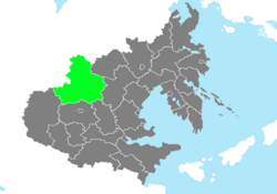
Shingang Province
This article is incomplete because it is pending further input from participants, or it is a work-in-progress by one author. Please comment on this article's talk page to share your input, comments and questions. Note: To contribute to this article, you may need to seek help from the author(s) of this page. |
Shingang Province | |
|---|---|
 Location of Shingang Province in Zhenia. | |
| Country | Zhenia |
| Capital | Seokmun |
| Largest City | Naseon |
| Reorganization into a Province | December 8, 1909 |
| Government | |
| • Governor | Baidur Rinchen (B) |
| Area | |
| • Total | 470,031.77 km2 (181,480.28 sq mi) |
| • Land | 469,326.72 km2 (181,208.06 sq mi) |
| • Water | 705.05 km2 (272.22 sq mi) 0.15% |
| • Rank | 2nd |
| Population (2020) | |
| • Total | 7,192,188 |
| • Density | 15.3/km2 (40/sq mi) |
| Demonym | Shingangese |
| Time zone | UTC+7 (ZWST) |
| Federal Postal Code | 31001-31999 |
| Provincial Code | SA |
Shingang Province (Zhenian: 신강도), is a Zhenian province located in Western Zhenia, situated directly at the nation's western border. As the second-largest province in the nation by area, it is home to the lowest population density in the nation as well, being home to just over 7 million residents. It is situated directly at the northwestern border of Zhenia, neighboring Heuksu Province to the southwest, Seogwang and Donggwang provinces to the south and Macheon Province to the northeast.
Situated at the former heartland of the Balakhaat people, what is now Shingang Province was a node in the transcontinental trade routes connecting the east and west. It later became a major component of the Kharlin Empire until the century-long Kharlin-Zhu Wars ultimately brought the area under submission to mainland Zhenia, after which much of the Balakhaat people relocated to nearby Macheon and Karavankon regions. During the Zhenian Civil War, it was one of the first province-level areas in mainland Zhenia to have sided with the Shindan dynasty; however, due to its strategic importance and low population density, it was designated as a territory during the Empire of Zhenia, until it was elevated into a province alongside other mainland Zhenian territories in 1909.

