Western Cona County: Difference between revisions
Jump to navigation
Jump to search
(Created page with "{{wip}} {{Garetolia icon}} {{Infobox settlement | official_name = Western Cona County | other_name = Uru'kona Kone | settlement_type = {{wp|County}} | image_skyline = {{Photom...") |
No edit summary |
||
| (9 intermediate revisions by the same user not shown) | |||
| Line 13: | Line 13: | ||
| position = center | | position = center | ||
| size = 270 | | size = 270 | ||
| color = white | |||
| foot_montage = Images, from top down, left to right: Coastal [[Ule'eka]], Downtown Ule'eka, [[Mount Urupaka]], [[Enchanted Peninsula, Garetolia|the Enchanted Peninsula]], | | foot_montage = Images, from top down, left to right: Coastal [[Ule'eka]], Downtown Ule'eka, [[Mount Urupaka]], [[Enchanted Peninsula, Garetolia|the Enchanted Peninsula]], | ||
}} | }} | ||
| image_seal = WestConaSeal.png | | image_flag = Flag of Western Cona County.png | ||
| seal_size = | | image_seal = WestConaSeal.png | ||
| seal_size = 75px | |||
| motto = ''Vilit'aka re' Kina'a'' <br/><small>(Greatness is our Pride)</small> | | motto = ''Vilit'aka re' Kina'a'' <br/><small>(Greatness is our Pride)</small> | ||
| image_map = <center>{{Garetolia labelled map (small)}}</center> | | image_map = <center>{{Garetolia labelled map (small)}}</center> | ||
| Line 23: | Line 25: | ||
| subdivision_type = Country | | subdivision_type = Country | ||
| subdivision_name = {{flag|Garetolia}} | | subdivision_name = {{flag|Garetolia}} | ||
| subdivision_type1 = Island | | subdivision_type1 = [[List of islands and atolls of Garetolia|Island]] | ||
| subdivision_name1 = [[Cona]] | | subdivision_name1 = [[Cona]] | ||
| established_title = | | established_title = Administrative center | ||
| established_date = [[Ule'eka]] | | established_date = [[Ule'eka]] | ||
| established_title1 = Incorporated | | established_title1 = Incorporated | ||
| established_date1 = 1895 | | established_date1 = 1895 | ||
| government_type = County | | government_type = County | ||
| leader_title1 = [[Western Cona | | leader_title1 = [[Governor of Western Cona|Governor]] | ||
| leader_name1 | | leader_name1 = [[Toleka Nanana]] | ||
| area_total_km2 = 4,744 | | area_total_km2 = 4,744 | ||
| area_total_sq_mi = 1,832 | | area_total_sq_mi = 1,832 | ||
| elevation_m = 2,351 | | elevation_m = 2,351 | ||
| elevation_ft = 7,714 | | elevation_ft = 7,714 | ||
| population_total = | | population_total = 102,683 | ||
| population_as_of = 2019 | | population_as_of = 2019 | ||
| population_density_km2 = auto | | population_density_km2 = auto | ||
| Line 56: | Line 47: | ||
| timezone_DST = KTST | | timezone_DST = KTST | ||
| utc_offset_DST = -9 | | utc_offset_DST = -9 | ||
| iso_code = KT-WC | |||
}} | }} | ||
'''Western Cona''' is the most populous [[Counties of Garetolia|county]] of [[Garetolia]]. | '''Western Cona''' is the most populous [[Counties of Garetolia|county]] of [[Garetolia]]. | ||
{{Garetolia topics}} | |||
Latest revision as of 08:52, 30 December 2022
This article is incomplete because it is pending further input from participants, or it is a work-in-progress by one author. Please comment on this article's talk page to share your input, comments and questions. Note: To contribute to this article, you may need to seek help from the author(s) of this page. |
Western Cona County
Uru'kona Kone | |
|---|---|
    Images, from top down, left to right: Coastal Ule'eka, Downtown Ule'eka, Mount Urupaka, the Enchanted Peninsula, | |
 Flag  Seal | |
| Motto(s): Vilit'aka re' Kina'a (Greatness is our Pride) | |
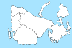
Western Cona County shown on map | |
| Country | |
| Island | Cona |
| Administrative center | Ule'eka |
| Incorporated | 1895 |
| Government | |
| • Type | County |
| • Governor | Toleka Nanana |
| Area | |
| • Total | 4,744 km2 (1,832 sq mi) |
| Elevation | 2,351 m (7,714 ft) |
| Population (2019) | |
| • Total | 102,683 |
| • Density | 22/km2 (56/sq mi) |
| Time zone | UTC-10 (KTT) |
| • Summer (DST) | UTC-9 (KTST) |
| ISO 3166 code | KT-WC |
| Website | www |
Western Cona is the most populous county of Garetolia.
| History |  | |
|---|---|---|
| Politics | ||
| Law | ||
| Military | ||
| Geography | ||
| Economy | ||
| Infrastructure | ||
| Society | ||
| Symbols | ||
| Wildfires | ||
| Miscellaneous | ||