Namhae Province: Difference between revisions
Jump to navigation
Jump to search
mNo edit summary |
mNo edit summary |
||
| (4 intermediate revisions by the same user not shown) | |||
| Line 1: | Line 1: | ||
{{ | {{WIP}} | ||
{{Infobox | |||
|native_name | {{Infobox settlement | ||
| | | name = Namhae Province | ||
| | | native_name = 남해도 | ||
|image_flag | | native_name_lang = | ||
| | | settlement_type = [[Administrative Areas of Zhenia#Provinces|Province]] | ||
| | | image_skyline = | ||
| | | image_alt = | ||
| | | image_caption = | ||
| | | image_flag = Flag of Namhae Province 2.png | ||
| | | flag_alt = Flag of Namhae Province. | ||
| | | image_seal = | ||
| | | seal_alt = | ||
| image_shield = | |||
|image_map | | shield_alt = | ||
| | | etymology = | ||
|map_caption | | nickname = | ||
| | | motto = | ||
| | | image_map = Namhae Province Map in Zhenia.png | ||
| map_alt = Location of Namhae Province in Zhenia marked in green. | |||
| | | map_caption = Location of Namhae Province in Zhenia. | ||
| | | pushpin_map = | ||
| | | pushpin_map_alt = | ||
| | | pushpin_map_caption = | ||
| | | pushpin_label_position = | ||
| | | coordinates = <!-- {{coord|latitude|longitude|type:city|display=inline,title}} --> | ||
| | | coor_pinpoint = | ||
| | | coordinates_footnotes = | ||
| | | subdivision_type = Country | ||
| subdivision_name = [[Zhenia]] | |||
| subdivision_type1 = Largest city | |||
| subdivision_name1 = [[Shinjin]] | |||
| subdivision_type2 = | |||
| subdivision_name2 = | |||
| subdivision_type3 = | |||
| | | subdivision_name3 = | ||
| | | established_title = Establishment | ||
| | | established_date = June 4, 1868 | ||
| | | founder = | ||
| | | seat_type = Capital | ||
| | | seat = [[Jin-Nampo]] | ||
| | | government_footnotes = | ||
| | | government_type = | ||
| | | governing_body = | ||
| | | leader_party = [[Union of Neo-Federalism|U]] | ||
| | | leader_title = Governor | ||
| | | leader_name = Seongho Kim | ||
| | | leader_title1 = | ||
| | | leader_name1 = | ||
| | | leader_title2 = | ||
| | | leader_name2 = | ||
| | | leader_title3 = | ||
| | | leader_name3 = | ||
| | | leader_title4 = | ||
| | | leader_name4 = | ||
| unit_pref = Metric | |||
<!-- ALL fields with measurements have automatic unit conversion --> | |||
| | <!-- for references: use <ref> tags --> | ||
| | | area_footnotes = | ||
| | | area_urban_footnotes = <!-- <ref> </ref> --> | ||
| area_rural_footnotes = <!-- <ref> </ref> --> | |||
| | | area_metro_footnotes = <!-- <ref> </ref> --> | ||
| | | area_magnitude = <!-- <ref> </ref> --> | ||
| | | area_note = | ||
| | | area_water_percent = 3.11% | ||
| | | area_rank = 23rd | ||
| | | area_blank1_title = | ||
| | | area_blank2_title = | ||
<!-- square kilometers --> | |||
| area_total_km2 = 91823.84 | |||
| | | area_land_km2 = 88968.12 | ||
| | | area_water_km2 = 2855.72 | ||
| | | area_urban_km2 = | ||
| | | area_rural_km2 = | ||
| | | area_metro_km2 = | ||
| | | area_blank1_km2 = | ||
| | | area_blank2_km2 = | ||
| | | elevation_footnotes = | ||
| | | elevation_m = | ||
| | | population_as_of = 2020 | ||
| | | population_footnotes = | ||
| | | population_total = 14,898,147 | ||
| | | population_density_km2 = auto | ||
| | | population_note = | ||
| | | population_demonym = | ||
| | | timezone1 = [[Time in Zhenia#Zhenia Eastern Standard Time|ZEST]] | ||
| | | utc_offset1 = +8 | ||
| timezone1_DST = | |||
| | | utc_offset1_DST = | ||
| | | postal_code_type = Federal Postal Code | ||
| | | postal_code = 09001-09999 | ||
| | | area_code_type = Provincial Code | ||
| | | area_code = NH | ||
| | | iso_code = | ||
| | | website = www.namhae.nh.zhen | ||
| | | footnotes = | ||
| | |||
|footnotes | |||
}} | }} | ||
'''Namhae Province''' ([[Zhenian language|Zhenian]]: '''남해도'''), is a [[Zhenia|Zhenian]] [[Administrative Areas of Zhenia#Provinces|province]] located in the [[Danguk Peninsula]]. Situated at the southern edge of the peninsula and hence facing the Gulf of Danguk to its west and the North Zhenian Sea to its and east, it is widely regarded as the eastern endpoint of the [[Golden Arc]] region. | '''Namhae Province''' ([[Zhenian language|Zhenian]]: '''남해도'''), is a [[Zhenia|Zhenian]] [[Administrative Areas of Zhenia#Provinces|province]] located in the [[Danguk Peninsula]], the eastern part of the nation. Situated at the southern edge of the peninsula and hence facing the Gulf of Danguk to its west and the North Zhenian Sea to its and east, it is widely regarded as the eastern endpoint of the [[Golden Arc]] region. | ||
==History== | ==History== | ||
==Geography== | ==Geography== | ||
==Politics== | |||
==Demographics== | |||
==Economy== | ==Economy== | ||
| Line 114: | Line 112: | ||
===Transportation=== | ===Transportation=== | ||
==Culture== | |||
==See Also== | |||
{{Template:Zhenia NavBox}} | {{Template:Zhenia NavBox}} | ||
[[Category:Zhenia]] | [[Category:Zhenia]] | ||
Latest revision as of 10:46, 2 April 2020
This article is incomplete because it is pending further input from participants, or it is a work-in-progress by one author. Please comment on this article's talk page to share your input, comments and questions. Note: To contribute to this article, you may need to seek help from the author(s) of this page. |
Namhae Province | |
|---|---|
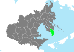
 Location of Namhae Province in Zhenia. | |
| Country | Zhenia |
| Largest city | Shinjin |
| Establishment | June 4, 1868 |
| Capital | Jin-Nampo |
| Government | |
| • Governor | Seongho Kim (U) |
| Area | |
| • Total | 91,823.84 km2 (35,453.38 sq mi) |
| • Land | 88,968.12 km2 (34,350.78 sq mi) |
| • Water | 2,855.72 km2 (1,102.60 sq mi) 3.11% |
| • Rank | 23rd |
| Population (2020) | |
| • Total | 14,898,147 |
| • Density | 160/km2 (420/sq mi) |
| Time zone | UTC+8 (ZEST) |
| Federal Postal Code | 09001-09999 |
| Provincial Code | NH |
| Website | www.namhae.nh.zhen |
Namhae Province (Zhenian: 남해도), is a Zhenian province located in the Danguk Peninsula, the eastern part of the nation. Situated at the southern edge of the peninsula and hence facing the Gulf of Danguk to its west and the North Zhenian Sea to its and east, it is widely regarded as the eastern endpoint of the Golden Arc region.

