Sotoa Sea: Difference between revisions
(Created page with "{{Infobox body of water | name = Sotoa Sea | other_name = | image = Sotoa Sea Satellite.png | alt = | caption =...") |
No edit summary |
||
| Line 30: | Line 30: | ||
| islands = | | islands = | ||
| cities = {{Collapsible list|title = List of cities| | | cities = {{Collapsible list|title = List of cities| | ||
*[[ | *[[Apelnisse]] | ||
*[[Balgita]] | *[[Balgita]] | ||
*[[Tarasto]] | *[[Tarasto]] | ||
Latest revision as of 18:51, 17 December 2021
| Sotoa Sea | |
|---|---|
 | |
| Location | West Nortua |
| Type | Sea |
| Primary outflows | Samson Ocean |
| Basin countries | Karabakhi, Constantio, Syraranto, Vuswistan, North Icadania |
| Surface area | 436,400 km2 (168,500 sq mi) |
| Average depth | 1,500 m (4,900 ft) |
| Max. depth | 3,237 km (2,011 mi) |
| Frozen | never |
| Settlements | |
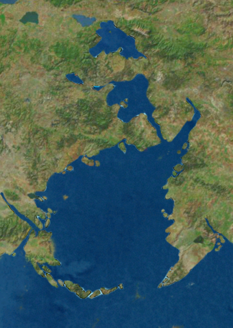
The Sotoa Sea is a large body of water in southwestern Nortua which stradles the southwest corner of the continent and is a basin to the Samson Ocean through the Yn Syth Strait. It is surrounded by the Sotoa Basin, a massive watershed network that flows into the sea from the mountains and highlands of Nortua. The sea played a central role in the history of civilization on the Nortuan continent. The sea was an important route for merchants and travelers of ancient times, facilitating trade and cultural exchange between peoples of the region. Basin countries include Karabakhi, Constantio, Syraranto, Vuswistan, and North Icadania. Taret Bay, located at the front of a strait leading into the sea from the north, is often considered part of the sea. Lake Bajani, which flows into Taret Bay, is sometimes also considered a part of the sea.