Tasiastan: Difference between revisions
No edit summary |
|||
| Line 97: | Line 97: | ||
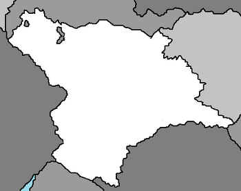
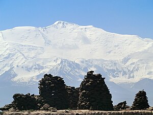
Tasiastan is landlocked with an area of 1,020,220 km2 (393,909 sq mi), bordered to the west by [[Yuan]] with the Archismann Mountains, to the north by [[Barangadesh]] (with multiple exclaves within Tasiastan's territory), to the east by [[Kylastan]], and to the south by [[Pekastan]] and [[Beleroskov]]. It is covered by mountains of the Archismann range, and most of the country is over 3,000 metres (9,800 ft) above sea level. The only major areas of lower land are in the north (part of the Taana Valley), and in the southern Tofarnihon and Takhsh river valleys, which form the [[Amu Erya]]. The capital of [[Jaljur]] is located on the eastern slopes above the Tofarnihon valley before it descends into the interior of the country. | Tasiastan is landlocked with an area of 1,020,220 km2 (393,909 sq mi), bordered to the west by [[Yuan]] with the Archismann Mountains, to the north by [[Barangadesh]] (with multiple exclaves within Tasiastan's territory), to the east by [[Kylastan]], and to the south by [[Pekastan]] and [[Beleroskov]]. It is covered by mountains of the Archismann range, and most of the country is over 3,000 metres (9,800 ft) above sea level. The only major areas of lower land are in the north (part of the Taana Valley), and in the southern Tofarnihon and Takhsh river valleys, which form the [[Amu Erya]]. The capital of [[Jaljur]] is located on the eastern slopes above the Tofarnihon valley before it descends into the interior of the country. | ||
About 2% of the country's area is covered by lakes, the best known of which are the following: | About 2% of the country's area is covered by lakes, the best known of which are the following: Orbsa, Tyuas, Eruass, Tyajb, Wittayb, and Sarez. | ||
Tasiastan's climate is continental, subtropical, and semiarid, with some desert areas. The climate changes drastically according to elevation, however. The Taana Valley and other lowlands are shielded by mountains from cold [[Antartique]] air masses, but temperatures in that region still drop below freezing for more than 100 days a year. In the subtropical northwestern lowlands, which have the highest average temperatures, the climate is arid, although some sections now are irrigated for farming. At Tasiastan's lower elevations, the average temperature range is 23 to 30 °C (73.4 to 86.0 °F) in January and −1 to 3 °C (30.2 to 37.4 °F) in July. In the eastern highlands, the average January temperature is 5 to 10 °C (41 to 50 °F), and the average July temperature is −15 to −20 °C (5 to −4 °F). | Tasiastan's climate is continental, subtropical, and semiarid, with some desert areas. The climate changes drastically according to elevation, however. The Taana Valley and other lowlands are shielded by mountains from cold [[Antartique]] air masses, but temperatures in that region still drop below freezing for more than 100 days a year. In the subtropical northwestern lowlands, which have the highest average temperatures, the climate is arid, although some sections now are irrigated for farming. At Tasiastan's lower elevations, the average temperature range is 23 to 30 °C (73.4 to 86.0 °F) in January and −1 to 3 °C (30.2 to 37.4 °F) in July. In the eastern highlands, the average January temperature is 5 to 10 °C (41 to 50 °F), and the average July temperature is −15 to −20 °C (5 to −4 °F). | ||
Revision as of 02:46, 26 November 2021
Democratic Republic of Tasiastan | |
|---|---|
|
Flag | |
 | |
| Capital and largest city | Jaljur |
| Official languages | Tasia |
| Language of inter-ethnic communication | Beleroskovian |
| Spoken languages | |
| Ethnic groups (2010) | |
| Religion |
|
| Demonym(s) | Tasiastani, Tasian |
| Government | Unitary dominant-party presidential constitutional republic |
| Haajid Swati | |
| Parshand Khosa | |
• Chairman of the Ajlisi Ailli | Eldemir Ansari |
| Legislature | Parliament |
| National Assembly | |
| Assembly of Representatives | |
| Formation | |
| Area | |
• Total | 393,909 sq mi (1,020,220 km2) |
• Water (%) | 1.8 |
| Population | |
• 2020 estimate | 65,788,000 |
| GDP (PPP) | 2018 estimate |
• Total | 36.547 billion |
• Per capita | 3,354 |
| GDP (nominal) | 2018 estimate |
• Total | 27.350 billion |
• Per capita | 807 |
| Gini (2021) | 34 medium |
| HDI (2019) | medium |
| Currency | wata (TWA) |
| Time zone | UTC+5 |
| Driving side | right |
| Calling code | +992 |
Tasiastan is a landlocked country in Ausiana, bordered by Yuan, Barangadesh, Kylastan, Pekastan, and Beleroskov. It has an area of 1,020,220 km2 (393,909 sq mi) and a population of 65,788,000. Its capital and largest city is Jaljur. The traditional homelands of the Tasian people include present-day Tasiastan as well as parts of Pekastan, Jaginistan, and Haduastan.
History
Geography
Tasiastan is landlocked with an area of 1,020,220 km2 (393,909 sq mi), bordered to the west by Yuan with the Archismann Mountains, to the north by Barangadesh (with multiple exclaves within Tasiastan's territory), to the east by Kylastan, and to the south by Pekastan and Beleroskov. It is covered by mountains of the Archismann range, and most of the country is over 3,000 metres (9,800 ft) above sea level. The only major areas of lower land are in the north (part of the Taana Valley), and in the southern Tofarnihon and Takhsh river valleys, which form the Amu Erya. The capital of Jaljur is located on the eastern slopes above the Tofarnihon valley before it descends into the interior of the country.
About 2% of the country's area is covered by lakes, the best known of which are the following: Orbsa, Tyuas, Eruass, Tyajb, Wittayb, and Sarez.
Tasiastan's climate is continental, subtropical, and semiarid, with some desert areas. The climate changes drastically according to elevation, however. The Taana Valley and other lowlands are shielded by mountains from cold Antartique air masses, but temperatures in that region still drop below freezing for more than 100 days a year. In the subtropical northwestern lowlands, which have the highest average temperatures, the climate is arid, although some sections now are irrigated for farming. At Tasiastan's lower elevations, the average temperature range is 23 to 30 °C (73.4 to 86.0 °F) in January and −1 to 3 °C (30.2 to 37.4 °F) in July. In the eastern highlands, the average January temperature is 5 to 10 °C (41 to 50 °F), and the average July temperature is −15 to −20 °C (5 to −4 °F).
Most of Tasiastan's environmental problems are related to the agricultural policies imposed on the country during the communist period. By 1991 heavy use of mineral fertilizers and agricultural chemicals was a major cause of pollution in the republic. Among those chemicals were DDT, banned by international convention, and several defoliants and herbicides. In addition to the damage they have done to the air, land, and water, the chemicals have contaminated the cottonseeds whose oil is used widely for cooking. Cotton farmers and their families are at particular risk from the overuse of agricultural chemicals, both from direct physical contact in the field and from the use of the branches of cotton plants at home for fuel. All of these toxic sources are believed to contribute to a high incidence of maternal and child mortality and birth defects. In 1994 the infant mortality rate was 43.2 per 1,000 births, the second highest rate among former communist republics in Ausiana. The rate in 1990 had been 40.0 infant deaths per 1,000 births.
Cotton requires particularly intense irrigation. In Tasiastan's cotton-growing regions, farms were established in large, semiarid tracts and in tracts reclaimed from the desert, but cotton's growing season is summer, when the region receives virtually no rainfall. The 50 percent increase in cotton cultivation mandated by communist and post-communist agricultural planners between 1964 and 1994 consequently overtaxed the regional water supply. Poorly designed irrigation networks led to massive runoff, which increased soil salinity and carried toxic agricultural chemicals downstream to other fields, lakes, and populated areas of the region.
Politics

Almost immediately after independence from Beleroskov in 1988, Tasiastan was plunged into a civil war that saw various factions fighting one another. These factions were supported by foreign countries including Pekastan, Haduastan, Beleroskov, and Yuan. Haduastan and Yuan focused on keeping peace in the warring nation to decrease the chances of Zamastanian or CCA involvement. Most notably, Yuan backed the pro-government faction and deployed troops from the People's Liberation Army of Yuan to the Yuan-Tasiastan border. All but 25,000 of the more than 200,000 ethnic Beleroskovians, who were mostly employed in industry, fled to Beleroskov. By 1990, the war had ended after a peace agreement between the government and the Islamist-led opposition, a central government began to take form, with peaceful elections in 1992.
Tasiastan is officially a republic, and holds elections for the presidency and Parliament, operating under a presidential system. It is, however, a dominant-party system, where the People's Democratic Party of Tasiastan routinely has a vast majority in Parliament. Haajid Swati has held the office of President of Tasiastan since November 2015. The Prime Minister is Parshand Khosa.

