User:Planita13/Sandbox3: Difference between revisions
mNo edit summary |
mNo edit summary |
||
| Line 1: | Line 1: | ||
{{Infobox settlement | {{Infobox settlement | ||
| name = {{Collapsible list|title=<center>Golden Isles</center>|<center><small>''Aruciennes Occidentales'' ({{wp|French language|Gaullican}})</small></center>}} | | name = {{Collapsible list|title=<center> New Aureans <br> Golden Isles </center>|<center><small>''Aruciennes Occidentales'' ({{wp|French language|Gaullican}})</small></center>}} | ||
| official_name = | | official_name = | ||
| image_map = Western Arucian Islands.png | | image_map = Western Arucian Islands.png | ||
| Line 11: | Line 11: | ||
| subdivision_name1 = {{flag|Bonaventure}} <br>{{flag|Carucere}}<br>{{flag|Imagua and the Assimas}} <br>{{flag|Sainte-Chloé}} | | subdivision_name1 = {{flag|Bonaventure}} <br>{{flag|Carucere}}<br>{{flag|Imagua and the Assimas}} <br>{{flag|Sainte-Chloé}} | ||
| subdivision_type2 = Dependencies | | subdivision_type2 = Dependencies | ||
| subdivision_name2 = [[ | | subdivision_name2 = [[Kajapas]], {{flag|Aucuria}} <br> [[Magdaliete]], {{flag|Aucuria}} <br> [[Vanö]], {{flag|Eldmark}} | ||
| admin_center_type = | | admin_center_type = | ||
| other_name = | | other_name = | ||
| Line 23: | Line 23: | ||
| population_total = 3,949,250 | | population_total = 3,949,250 | ||
| population_density_km2 = 274.9 | | population_density_km2 = 274.9 | ||
| population_demonym = | | population_demonym = Aureans <br> New Aureans | ||
| timezone = | | timezone = | ||
| utc_offset = | | utc_offset = | ||
| Line 29: | Line 29: | ||
| utc_offset_DST = | | utc_offset_DST = | ||
}} | }} | ||
The '''Golden Isles''' is | The '''New Aureans''', also commonly known as the '''Golden Isles''', is a group of islands in the Western [[Arucian Sea]]. The {{wp|archipelago}} lies in the middle of the sea in a cluster between the southern coast of [[Asteria Superior]] and the northern coast of [[Asteria Inferior]]. The islands are largely volcanic formed by a significant cluster of {{wp|Hotspot (geology)|hotspots}} and tectonic activity. The islands vary significantly in size from small {{wp|Islet|islets}}, {{wp|reef|reefs}}, and {{wp|cay|cays }} to large islands. Together, the Golden Isles and the Emerald Isles make up the [[Arucian]]. Geopolitically, the islands of the New Aureans are often regarded as a region of [[Asteria Superior]], though parts of it are sometimes included in [[Asteria Inferior]] or left as a region of their own. | ||
One of the earliest regions first explored and discovered by the [[Euclea|Euclean]] states, the islands were settled by many different colonial powers. | One of the earliest regions first explored and discovered by the [[Euclea|Euclean]] states, the islands were settled by many different colonial powers from the 15th century up to the early 20th century. As a result, they share a common historical, cultural, and political heritage. Today the islands consists of four {{wp|Sovereign state|independent countries}} and three {{wp|Dependent territory|dependencies}} of neighboring states. | ||
==History== | |||
==Geography== | |||
==Demographics== | |||
==Languages== | |||
==List of countries and dependencies== | |||
Revision as of 03:31, 29 July 2022
Golden Isles
| |
|---|---|
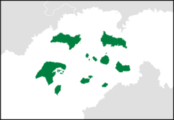
 The Golden Isles in green | |
| Region | Arucian |
| Island States | File:ImaguaFlag.png Imagua and the Assimas |
| Dependencies | Kajapas, Magdaliete, Vanö, File:Eldmark.png Eldmark |
| Area | |
| • Total | 182,848.06 km2 (70,598.03 sq mi) |
| Population (2009) | |
| • Total | 3,949,250 |
| • Density | 274.9/km2 (712/sq mi) |
| Demonym(s) | Aureans New Aureans |
The New Aureans, also commonly known as the Golden Isles, is a group of islands in the Western Arucian Sea. The archipelago lies in the middle of the sea in a cluster between the southern coast of Asteria Superior and the northern coast of Asteria Inferior. The islands are largely volcanic formed by a significant cluster of hotspots and tectonic activity. The islands vary significantly in size from small islets, reefs, and cays to large islands. Together, the Golden Isles and the Emerald Isles make up the Arucian. Geopolitically, the islands of the New Aureans are often regarded as a region of Asteria Superior, though parts of it are sometimes included in Asteria Inferior or left as a region of their own.
One of the earliest regions first explored and discovered by the Euclean states, the islands were settled by many different colonial powers from the 15th century up to the early 20th century. As a result, they share a common historical, cultural, and political heritage. Today the islands consists of four independent countries and three dependencies of neighboring states.