New Mina: Difference between revisions
(Created page with "{{Infobox settlement | name = New Mina | native_name = ''La Nouvelle-Mina'' ({{wp|French language|Gaullican}})<br>''Mukoma'' ({{wp|Shona languag...") |
No edit summary |
||
| Line 112: | Line 112: | ||
}} | }} | ||
'''New Mina''' (Gaullican: ''La Nouvelle-Mina''), also known as '''Mukoma''' in veRwizi (its official name from 1954 to 1968) is a {{wp|planned city}} in [[Garambura]]. It lies directly south of [[Maware]] and together forms the Maware-New Mina Urban Zone, and is part of the Maware province. As of 2020, New Mina has a population of | '''New Mina''' (Gaullican: ''La Nouvelle-Mina''), also known as '''Mukoma''' in veRwizi (its official name from 1954 to 1968) is a {{wp|planned city}} in [[Garambura]]. It lies directly south of [[Maware]] and together forms the Maware-New Mina Urban Zone, and is part of the Maware province. As of 2020, New Mina has a population of 298,114, with the second highest rate of immigration into the city behind [[Mambiza]]. New Mina was shortlisted for the capital of Garambura in 1970, but ultimately lost out to [[Mutimukuru]] on the southern coast. | ||
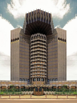
While the site of New Mina had been settled for hundreds of years as villages south of Maware, it began life as a planned capital of the [[United Bahian Republic]] in 1954. Djedi architect [[Brehan Belai]] was chosen to design the city, which was to feature infrastructure to house the governmental institutions of the United Bahian Republic and the subsequent population influx in and out of the city that would come with a designated capital. New Mina was renowned for its ambition and modernist architecture, which somewhat reflected the architectural scene in post-war Mina, hence its name. The city was opened officially and incorporated in 1968, however the necessary arrangements to move the central capital to New Mina were not completed before the Republic fell apart as a result of [[Tabora]] declaring independence in 1964 and the subsequent [[Garamburan War of Independence]] in 1969. | While the site of New Mina had been settled for hundreds of years as villages south of Maware, it began life as a planned capital of the [[United Bahian Republic]] in 1954. Djedi architect [[Brehan Belai]] was chosen to design the city, which was to feature infrastructure to house the governmental institutions of the United Bahian Republic and the subsequent population influx in and out of the city that would come with a designated capital. New Mina was renowned for its ambition and modernist architecture, which somewhat reflected the architectural scene in post-war Mina, hence its name. The city was opened officially and incorporated in 1968, however the necessary arrangements to move the central capital to New Mina were not completed before the Republic fell apart as a result of [[Tabora]] declaring independence in 1964 and the subsequent [[Garamburan War of Independence]] in 1969. | ||
Revision as of 17:41, 3 February 2020
New Mina
| |
|---|---|
City | |
 The Liberty Building in central New Mina. | |
| Etymology: Mina, Djedet | |
| Country | Garambura |
| Province | Maware |
| Construction began | 1954 |
| Incorporated | 1968 |
| Renamed New Mina | 1970 |
| Government | |
| • Governor | Taropafadzwa Mutawa |
| Area | |
| • Urban | 380.23 km2 (146.81 sq mi) |
| • Metro | 591 km2 (228 sq mi) |
| Population (2020) | |
| • City | 298,114 |
| Time zone | UTC+4 (Eastern Bahian Time) |
| Website | cityofnewmina |
New Mina (Gaullican: La Nouvelle-Mina), also known as Mukoma in veRwizi (its official name from 1954 to 1968) is a planned city in Garambura. It lies directly south of Maware and together forms the Maware-New Mina Urban Zone, and is part of the Maware province. As of 2020, New Mina has a population of 298,114, with the second highest rate of immigration into the city behind Mambiza. New Mina was shortlisted for the capital of Garambura in 1970, but ultimately lost out to Mutimukuru on the southern coast.
While the site of New Mina had been settled for hundreds of years as villages south of Maware, it began life as a planned capital of the United Bahian Republic in 1954. Djedi architect Brehan Belai was chosen to design the city, which was to feature infrastructure to house the governmental institutions of the United Bahian Republic and the subsequent population influx in and out of the city that would come with a designated capital. New Mina was renowned for its ambition and modernist architecture, which somewhat reflected the architectural scene in post-war Mina, hence its name. The city was opened officially and incorporated in 1968, however the necessary arrangements to move the central capital to New Mina were not completed before the Republic fell apart as a result of Tabora declaring independence in 1964 and the subsequent Garamburan War of Independence in 1969.
New Mina is home to the largest community of Orthodox Beheirans outside of Djedet, with an estimated population of 180,000 within the city, over 50% of its total demographic. New Mina houses the Patriarchate of Baséland, the Orthodox denomination of Garambura, as well as many other Orthodox churches. New Mina's unique blend of religious symbolism with modernist architecture has led it to be called one of the most culturally unique cities in the world.
