Imhae Province: Difference between revisions
Jump to navigation
Jump to search
mNo edit summary |
m (Infobox change.) |
||
| Line 1: | Line 1: | ||
{{Under Construction}} | {{Under Construction}} | ||
{{Infobox | {{Under Construction}} | ||
|native_name | {{Infobox settlement | ||
| | | name = Imhae Province | ||
| | | native_name = 임해도 | ||
|image_flag | | native_name_lang = | ||
| | | settlement_type = [[Administrative Areas of Zhenia#Provinces|Province]] | ||
| | | image_skyline = | ||
| | | image_alt = | ||
| | | image_caption = | ||
| | | image_flag = Flag of Imhae Province 2.png | ||
| | | flag_alt = Flag of Imhae Province. | ||
| | | image_seal = | ||
| | | seal_alt = | ||
| image_shield = | |||
|image_map | | shield_alt = | ||
| | | etymology = | ||
|map_caption | | nickname = | ||
| | | motto = | ||
| | | image_map = Imhae Province Map in Zhenia.png | ||
| | | map_alt = Location of Imhae Province in Zhenia marked in green. | ||
| | | map_caption = Location of Imhae Province in Zhenia. | ||
| | | pushpin_map = | ||
| | | pushpin_map_alt = | ||
| | | pushpin_map_caption = | ||
| | | pushpin_label_position = | ||
| | | coordinates = <!-- {{coord|latitude|longitude|type:city|display=inline,title}} --> | ||
| | | coor_pinpoint = | ||
| | | coordinates_footnotes = | ||
| | | subdivision_type = Country | ||
| subdivision_name = [[Zhenia]] | |||
| subdivision_type1 = Largest city | |||
| subdivision_name1 = [[Namgyeong]] | |||
| subdivision_type2 = | |||
| subdivision_name2 = | |||
| subdivision_type3 = | |||
| | | subdivision_name3 = | ||
| | | established_title = Reorganization into a Province | ||
| | | established_date = December 8, 1909 | ||
| | | founder = | ||
| | | seat_type = Capital | ||
| | | seat = [[Namgyeong]] | ||
| | | government_footnotes = | ||
| government_type = | |||
| | | governing_body = | ||
| leader_party = [[N|New Nationalist Party]] | |||
| | | leader_title = Governor | ||
| | | leader_name = Jin Meiwang | ||
| | | leader_title1 = | ||
| | | leader_name1 = | ||
| | | leader_title2 = | ||
| | | leader_name2 = | ||
| | | leader_title3 = | ||
| | | leader_name3 = | ||
| | | leader_title4 = | ||
| | | leader_name4 = | ||
| | | unit_pref = Metric | ||
<!-- ALL fields with measurements have automatic unit conversion --> | |||
| | <!-- for references: use <ref> tags --> | ||
| | | area_footnotes = | ||
| | | area_urban_footnotes = <!-- <ref> </ref> --> | ||
| | | area_rural_footnotes = <!-- <ref> </ref> --> | ||
| | | area_metro_footnotes = <!-- <ref> </ref> --> | ||
| | | area_magnitude = <!-- <ref> </ref> --> | ||
| | | area_note = | ||
| | | area_water_percent = 3.91% | ||
| | | area_rank = 22nd | ||
| | | area_blank1_title = | ||
| area_blank2_title = | |||
<!-- square kilometers --> | |||
| | | area_total_km2 = 113703.1 | ||
| | | area_land_km2 = | ||
| | | area_water_km2 = | ||
| | | area_urban_km2 = | ||
| | | area_rural_km2 = | ||
| | | area_metro_km2 = | ||
| | | area_blank1_km2 = | ||
| | | area_blank2_km2 = | ||
| | | elevation_footnotes = | ||
| | | elevation_m = | ||
| | | population_as_of = 2020 | ||
| | | population_footnotes = | ||
| | | population_total = 24,888,681 | ||
| | | population_density_km2 = auto | ||
| | | population_note = | ||
| | | population_demonym = Imhaean | ||
| | | timezone1 = [[Time in Zhenia#Zhenia Eastern Standard Time|ZEST]] | ||
| utc_offset1 = +8 | |||
| | | timezone1_DST = | ||
| | | utc_offset1_DST = | ||
| | | postal_code_type = Federal Postal Code | ||
| | | postal_code = 24001-24999 | ||
| | | area_code_type = Provincial Code | ||
| | | area_code = 24 | ||
| | | iso_code = | ||
| | | website = www.imhae.ih.zhen | ||
| | | footnotes = | ||
|footnotes | |||
}} | }} | ||
'''Imhae Province''' ([[Zhenian language|Zhenian]]: '''임해도'''), is a [[Zhenia|Zhenian]] [[Administrative Areas of Zhenia#Provinces|province]] located in [[Southern Zhenia]]. Facing the Gulf of Danguk to its south and east, it is a southwestern component of the [[Golden Arc]] region. | '''Imhae Province''' ([[Zhenian language|Zhenian]]: '''임해도'''), is a [[Zhenia|Zhenian]] [[Administrative Areas of Zhenia#Provinces|province]] located in [[Southern Zhenia]]. Facing the Gulf of Danguk to its south and east, it is a southwestern component of the [[Golden Arc]] region. | ||
| Line 107: | Line 102: | ||
==Geography== | ==Geography== | ||
==Politics== | |||
===Government=== | |||
==Demographics== | |||
==Economy== | ==Economy== | ||
| Line 113: | Line 114: | ||
===Transportation=== | ===Transportation=== | ||
==Culture== | |||
==See Also== | |||
* [[Administrative Areas of Zhenia]] | |||
* [[Provinces of Zhenia]] | |||
{{Template:Zhenia NavBox}} | {{Template:Zhenia NavBox}} | ||
[[Category:Zhenia]] | [[Category:Zhenia]] | ||
[[Category:INWU]] | [[Category:INWU]] | ||
Revision as of 19:00, 24 February 2020
Imhae Province | |
|---|---|
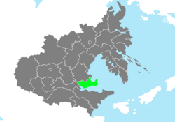
 Location of Imhae Province in Zhenia. | |
| Country | Zhenia |
| Largest city | Namgyeong |
| Reorganization into a Province | December 8, 1909 |
| Capital | Namgyeong |
| Government | |
| • Governor | Jin Meiwang (New Nationalist Party) |
| Area | |
| • Total | 113,703.1 km2 (43,901.0 sq mi) |
| • Rank | 22nd |
| Population (2020) | |
| • Total | 24,888,681 |
| • Density | 220/km2 (570/sq mi) |
| Demonym | Imhaean |
| Time zone | UTC+8 (ZEST) |
| Federal Postal Code | 24001-24999 |
| Provincial Code | 24 |
| Website | www.imhae.ih.zhen |
Imhae Province (Zhenian: 임해도), is a Zhenian province located in Southern Zhenia. Facing the Gulf of Danguk to its south and east, it is a southwestern component of the Golden Arc region.

