Sattarishahr
Sattarishahr ساتاریستی | |
|---|---|
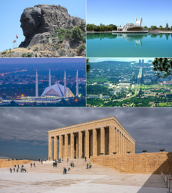
 From clockwise top left; the Mahrdad Ali Sattari Monument, Sattarishahr Garden, Avenue of the Union, Mausoleum of the Union Fathers and Mahyar Vaziri Grand Mazar. | |
| Etymology: Sattari City | |
| Country | Zorasan |
| Union Municipality | Union Capital Territory |
| Constructed | 2010 |
| Inaugurated | 10 June 2016 |
| Government | |
| • Type | Mayor-council |
| • Body | Municipal Central Committee |
| • Mayor | Asghar Sazegara (National Renovation Front) |
| • Deputy Mayor | Ezzatollah Yazdanfar |
| Area | |
| • Urban | 230 km2 (90 sq mi) |
| • Metro | 1,147 km2 (443 sq mi) |
| Elevation | 1,387 m (4,551 ft) |
| Population (2021) | |
| • Federal capital city | 2,365,702 |
| Demonym | Sattarishahi |
| Time zone | UTC+0 (ZOT) |
| Area code | 001 |
Sattarishahr (Pasdani: ساتاریستی, solarianised: Sattārishahr) is the capital city of Zorasan and is governed by the Zorasani federal government through the Union Capital District, which encompasses the city and its surrounding environs. Initially built as a planned city within the Tinnin Plateau region to support population growth in the 2000s, it was proclaimed the new capital in 2016 replacing Zahedan as the nation's capital. It is the Xth largest city in Zorasan. The city has consistently topped national rankings for high standards of living, public safety, cleanliness, greenery and transportation.
Sattarishahr was originally planned as a new city to ease pressure on the then capital, Zahedan. However, the congestion of Zahedan, coupled with a desire to reduce the logistical burden on the city resulted in the government deciding to use the existing plans to construct a new capital. The master plan was designed by Zorasani architects, Hamid Ali Shabestari and Farhad Hadadifar and divides the city into nine zones, including government, a diplomatic quarter, residential, commercial, cultural, educational and industrial. A significant focus of the masterplan was placed on green spaces, a reduction in density of buildings and integration with nature. The 2010 decision for the new city to become the capital was followed by alterations to the masterplan, which now included space for national monuments and a enlarged government zone. Construction of the city also included the establishment of a new national park encompassing the Abolkhayr foothills of the Tinin Mountains, and the construction of an artificial lake in the heart of the city. The city includes landmarks such as the Mausoleum of the Union Fathers, Mahrdad Ali Sattari Monument, Sardar Javad Jahandar Culture Centre, Sattarishahr Garden Conference Hall and the Mahyar Vaziri Grand Mazar, the world’s fifth largest Mazar.
Sattarishahr is ranked as Beta+ city and is noted for its high cost of living, with an overwhelming majority of the city's population being of the middle and upper classes. Emigration to the city is severely restricted, to preserve the city's open spaces and quality of life. The vast majority of its citizens are employees of the government institutions and agencies based in the city, leading many commenators to claim its population is near entirely comprised of members of the ruling National Renovation Front and loyal government workers.
Etymology
Under the original plans for the city, it was to inaugurate with the name of "Abolkhayrshahr" (ابوالخیرشهر; Abolkhayr City), after the foothills where it is located. The decision to instead construct over the plans a new national capital resulted in a government initiative to have the general populace choose the new name. In late 2014, two years before its inauguration, the Supreme Assembly of the Union passed a motion proposing Sattarishahr (Sattari City), Ettehadshahr (Union City) and Abolkhayrshahr as three options to be voted upon online by the population. Between January and March 2015, 88.4 million Zorasanis voted via the official government website on the options, with Sattarishahr topping the poll at 77.56%, followed by Ettehadshahr and Abolkhayrshahr.
Sattarishahr (ساتاریستی; Rahelian: ستاريشهر; Kexri: ساتاریشەهر; Togoti: ساتاریستی) literally means Sattari City and is named after Mahrdad Ali Sattari, the 20th century Pan-Zorasanist and founder of National Renovationism and the Union of Khazestan and Pardaran, the predecessor to modern day Zorasan.
History
Early history
Sattarishahr is located on the northern slopes of the Tinnin Plateau and the Abolkhayr Foothills, this area has provided rich fertile soil for millenia and as such, hosts some of the earliest evidence of human habitation in Pardaran. During construction of the city, preliminary studies by the Union Institute of Antiquities and the National Museum of History discovered artefacts dating as far back as 100,000 to 500,000 years. The area around the man-made Lake Aramish, archeologists discovered relics and human remains dating back to 5,000 BCE, confirming the area of Sattarishahr had been home to a Neolithic people and developed into organised but small communities. The lake area also hosted relics with Galdian design, indicating that the neolithic communities had communications and links with the civilisation.
The region was also documented during the Sorsanid Empire for its fertile soil and a number of villages and communities were developed both on the plains north of the Tinnin Plateau and within the valleys of the Abolkhayr Foothills, including Hasanakdar, a restored village near the Khordad Garden Overlook, which exists as a living museum to pre-Irfanic Zorasan.
The area around District 3, in eastern Sattarishahr, is recorded as the location where the 5th Banner Army of the Pardarian Revolutionary Resistance Command crossed the Tinnin Mountains from Zahedan during its march on Chaboksar during the final stages of the Pardarian Civil War in 1949.
Original plans
Plans for a new city within the Tinnin Plateau were devised in the late 2000s as a means of relieving the pressure on Zahedan, which saw its population exceed 10 million in 2008. The planning of this new city was delegated to the State Commission for Urban Development, subordinate to the Central Committee of State, the highest decision making body in the country. The planning of this new city also took on significant symbolism as it would be the first major national project following the instability of the Turfan. The plans devised by the State Commission advocated for a city of 2-3 million and for a premium to be placed on green spaces, quality of life and integration with nature. These considerations stood in stark contrast to all of Zorasan’s major cities which had undergone dramatic expansion since unification in 1980 and had seen a marked degradation in its green and open spaces. However, revisions in the Third Edition Plan undercut these considerations with the addition of spaces for heavy industry, primarily in manufacturing and the chemical industry.
The location of the city was determined by its possible connections to Zahedan and the TransGulf Highway running parallel to the Zorasani coastline. The original location, some 22 miles north of Zahedan was rejected due to difficult topography and instead, the site of the city was moved 10 miles east, requiring extensions of the C3 Mountain Road, this area also boasted better topography, a higher water table for exploitation and several hills determined to be conducive to “tourism and cultural activities.”
The State Commission estimated that construction would cost ₮185 billion (€10.2 billion), this figure was earmarked in the 2009 Budget and would be covered by the Union Sovereign Fund as well as private creditors, including the Zorasani military. The plans, site and budget were proposed to the Supreme Assembly of the Union on 3 April 2009 and passed unanimously, this was followed by a unanimous vote by the Central Committee of State on April 5. The State Commission then began to vet architects for the project, ultimately settling on Hamid Ali Shabestari and Farhad Hadadifar, who had devised various buildings and entire districts for Badar-e Sattari and Mina al-Majid over the past two decades. They began work on a masterplan using the State Commission's considerations and conditions, though this masterplan completed by August 2009, had to undergo revisions following the decision to use the new city as the foundation for a new national capital.
However, before construction began, the State Commission proposed on its own initiative to use the plans to construct a new national capital, citing a 2007 study detailing the growing pressure on Zahedan as well as previous proposals for a new national capital made in 1990 and 1999.
New Capital
In May 2009, the State Commission for Urban Development launched a review on Zahedan’s long-term viability as the national capital. The study conducted by several think tanks and the Union Capital Government determined that the city’s population growth and overburdened transportation system would continue to be detrimental to the running of government. One of the most consistent criticisms of Zahedan was the dispersal of government ministries and agencies across a vast area of the city’s core. Many government ministries and agencies had complained of disruption caused by traffic and road closures, while the study also raised repeated concerns over the security of government, citing the dispersal of institutions and density of population. The Strategic Policy Planning Department of the National Renovation Front also supported the construction of a new capital to loosen the politico-economic centrality of Zahedan within long-term government plans. Proposals for a new capital had been made in the past, with a 1990 Proposal including the construction of a city in the geographical centre of the country, while a 1999 proposal suggested constructing a city on Lake Zindarud. Both proposals were rejected out of cost constraints and the relative isolation of both sites in relation to national infrastructure.
The 2009 study was accepted and a formal proposal to use the existing city plans for a new national capital was sent to the Central Committee of State. In June, the Central Committee agreed to the proposal, claiming a new capital would symbolise the “rebirth of Zorasan” following the Turfan and also be a “symbol of the nation’s industriousness and capacity for growth.” The Central Committee then put the proposal to the Supreme Assembly which unanimously agreed on June 22nd. With the plans for the new city and capital confirmed, this resulted in multiple revisions to the masterplan devised by Shabestari and Hadadifar, who also invited Abdulmalik Garras and Hossein Shirazi to join their team, two architects well respected for their works on national monuments in Zahedan.
The new masterplan was simplified but altered considerably, the city's zones were reduced to nine from eighteen. There would now be much larger government district; originally set for municipal governance, a diplomatic district to house foreign embassies and consulates, three residential districts, a commercial district, a cultural district, educational and industrial. Plans were also adopted for the construction of a Central Authority Complex, housing the highest decision making bodies of government and the core bodies of the ruling National Renovation Front. With the geographical site of the city already chosen, the Design Team took to idenitifying areas for "monuments and landmarks celebrating the Union and the Arduous Revolution. This included a unified monument to the Union Fathers, areas of rememberance and national reflection. Additional plans were included for new higher education institutions, a new hub for the armed forces and state security services, constitutional court and facilities for a new stock exchange and the Union Central Bank. The final revision to the masterplan came in October for the inclusion of a large manmade lake, to host a large park.
Construction

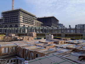
Construction officially began on the 18 March 2010 and would proceeded in five phases over a six year period. The construction of the city was undertaken by a consortium of private and state-owned enterprises, with the majority of workers being provided by the Union Ministry for Industry and Labour through the Union Construction and Development Corporation and the Union Labour Corps (a military enterprise). Private buisinesses included Aldar Developments, Khorramabad Services and Tajdid. Over 45,000 Zorasani soldiers undertaking their national service also contributed to the work force. It was during the initial construction phases that over 495 properties, mostly single-family run farms were seized and demolished. 2,596 people were displaced by the construction of Sattarishahr and all were guaranteed financial packages and new homes in the city as compensation. The estimated 102,000 strong workforce was housed in temprorary housing in what would later become Zone 8.

Phase 1 (2010-2012) of the construction effort focused on improving and expanding transport links, linking the city's site with the TransGulf Highway and the C3 Mountain Road and constructing the necessary water, gas and heating facilities. Two gas power stations were build between 2010 and 2014, to provide energy for over 900,000 homes, while three transistor stations were built to connect the entire Union Capital Territory to the national energy grid. A large lake 22km west of the city was turned into an artificial resevoir to facilitate the city's water-supply. A second resevoir was completed in 2015, filled via water pipeline carrying water from the Great Steppe over 900km away. Sewers, pipes and other subterreanean utilities were built over Phase 1.
Phase 2 (2012-2014) saw the first Zones be constructed, beginning with Zones 2, 3 and 4. These zones are notably of mixed use with residential, commercial and financial districts built. Zone 1 was also begun in this phase but would continue until 2016. Numerous private property developing companies focused on the construction of residential units, commerical and business units. State-owned enterprises involved in the construction during this phase also built police and fire stations, as well three major hospitals.
Phase 3 (2014-2015) this saw continued work on Zones 1, 2, 3 and 4, as well as the beginning of construction on Zones 5 and 6. Major educational institutions were also constructed in this phase including the Sattarishahr Academy for Engineering and Technology, the Union Institute for Science and Technology, the Sattarishahr Metropolitan University and the Sattarishahr Medical Research University. Construction began on Sattarishahr International Airport and Sayyad Ali Gharazi Airport (a mixed civil-military facility). By the end of this phase, all government ministry buildings had been completed. The Central Authority Compound was laid in this phase and would not be completed until 2016. By the end of this phase, Sattarishahr could support a population of 1.2 million, from 2014 government employees in Zahedan began to move into the city, coupled with pre-selected new emigrants seeking jobs and opportunities.
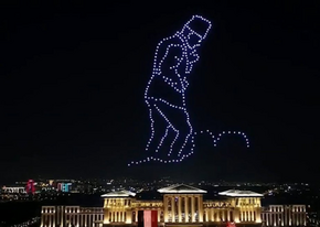
Phase 4 (2015-2016) saw the completetion of Zones 1, 2, 3, 4 and 5. Zones 8, 9 and 10 would be laid in this phase, while the that would become Zone 10 was purchased by the government and protected for future growth. This phase also saw the completetion of the Central Authority Compound, the National Mausoleum of the Union Fathers, the State Cemetary for Martyrs of the Union, the National Defence Headquarters, the National Police Academy and the headquarters of the Union Central Bank. The Shahid Al-Atassi Line of the Sattarishahr Metro was completed in early January 2016, with a total of eight stations. The landscaping of Aramish Park was also completed in early 2016, this coincided with public anger and frustration at the filling of Lake Aramish with fresh water, at a time when the southern regions of Pardaran and the Union Republics of Bagatistan, Ravanistan and Janubistan were suffering from drought and water shortages. The Fourth Phase came to an end on 9 June 2016, the following day and night major festivities took place as the city was officially inaugurated as the federal capital by State President of the Union Farid Isfandiar.
