Zahedan
This article is incomplete because it is pending further input from participants, or it is a work-in-progress by one author. Please comment on this article's talk page to share your input, comments and questions. Note: To contribute to this article, you may need to seek help from the author(s) of this page. |
Zahedan زاهدان | |
|---|---|
| قلمرو سرمایه اتحادیه زاهدان Ettehād-ye Khetteh-Khelafah-ye Zâhedân Union Capital Territory of Zahedan | |
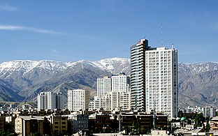
 From the top clockwise: Panorama of Zahedan's skyline; Grand Bazaar; Shahid Feredyun Mazar; Nowruz Park; Inqelab Tower | |
 Flag | |
 Location of the Zahedan UCT in Zorasan | |
 | |
| Country | |
| Union Territory | Federal Capital |
| Foundation | ~1123 BC As Sangavar |
| Districts | 10 Districts
|
| Government | |
| • Type | Mayor-council |
| • Body | Common Council |
| • Mayor | Nasser Khosroshahi |
| • Common Council Chairman | Adavazdar Rehbar |
| Area | |
| • Urban | 1,200 km2 (500 sq mi) |
| • Metro | 3,235 km2 (1,249 sq mi) |
| Elevation | 910 m (2,990 ft) |
| Population | |
| • Urban | 10,033,000 |
| • Metro | 17,998,378 |
| Demonym | Zahedani |
| Area code | (+98) 021 |
Zahedan (Pasdani: زاهدان; Zâhedân), officially the Union Capital Territory of Zahedan (قلمرو سرمایه اتحادیه زاهدان; Ettehād-ye Khetteh-Khelafāh-ye Zâhedân), is the capital and largest city of Zorasan. With a population of around 10 million in the city and 17 million in the larger metropolitan area of the Greater Union Territory, Zahedan is the most populous city in Zorasan and in Northern Coius and has the xx-largest metropolitan area in Coius overall. It is ranked XXth in the world by the population of its metropolitan area.
Zahedan has been a major settlement for over two millenia, being founded in 1123 BC by King Pishkar III as Sangavar. The city was renamed to Zahedan in 647 BC following the Devotion of Sangavar during the Rise of Irfan. The city would remain grow to become a prominent centre for commerce, culture and learning throughout ancient history, before emerging as one of the world's largest cities during the early middle ages. The city would suffer during the mid-20th century suffering attacks during the Great War, Solarian War and Pardarian Civil War. Following the unification of Pardaran in wake of the civil war in 1950, the city was rapidly rebuilt and modernised. The advent of industrialisation saw numerous waves of mass migrations and urban expansion, this led to Zahedan becoming of the one of the world's fastest growing cities throughout the 20th century. Arts, music, film, and cultural festivals were established towards the end of the 20th century and continue to be hosted by the city today. Infrastructure improvements have produced a complex transportation network in the city.
Today, the city is one of the largest in Coius and the world, it is the country's economic, political and economic hub, hosting several of the country's largest companies and industries. Zahedan is estimated to produce 18% of Zorasan's gross national product, and is considered to be a global city. In recent years, the city has begun to struggle with overdevelopment, water shortages and air pollution.
Etymology
Upon its founding, the city was initially refered to as Sangavar. Historians have regularly debated the origin of the name Sangavar, though a rising consensus is that the name was a constructed word produced by King Pishkar III, who sought a new capital to represent his person and reign. However, the name Zahedan (زاهدان; Zâhedân) was bestowed upon the city by the Irfanic Prophet Adavazdar in 648 BC, following the Devotion of Sangavar. The city's peaceful surrender and conversion to the Army of Adavazdar is widely accepted as being the origin for the name Zahedan, which derives from the plural of the Pasdani word "zâhid" (زاهد), meaning 'pious'.
History
Founding
Ancient and classical
Middle Ages
Early Modern
Modern
20th Century
Present
Geography
Zahedan is located at the near centre of Pardaran, in central-western Zorasan on the southern slopes of the Soban Mountains. To the south of Zahedan is the, to the south of Zahedan is the far-western reaches of the Dasth-e Aftab desert, though to the south-west of the city is the XX Steppe region. Owing to its location on the Pardarian Plateau, Zahedan rises on average 900m above sealevel, making it the highest city in the country.

Climate

Zahedan has a cold semi-arid climate (Köppen climate classification: BSk) with continental climate characteristics and a Solarian climate precipitation pattern. Zahedan's climate and precipitation is largely defined by its geographic location, with the towering Soban mountains to its north, the Dasht-e Aftab desert to the south-east and the XX Steppe region to the south-west. It can be generally described as mild in spring and autumn, hot and dry in summer, and cold and wet in winter. Due to the city's large area and location on the steps of the Soban mountains, there are significant differences in elevation across the various districts of the city. These differences are also notable in terms of weather, where the hilly northern districts are cooler than the southern flatter districts that approach the desert. The differences are most profound between Niavaran district in the north which sits at an elevation of 1,801 m (5,908 ft) above sea level, against Sattari district which rests just 911 m (2,988 ft) above sea-level in the south.
Between its founding and as late as the 14th century, Zahedan is bi-sected north-east to south-west by a small river that originated in the heights of the Soban mountains to the north. Known as the Pishkar River, it's widest point was only 10 meters and provided the city with a source of clean drinking water and sanitation, however, the city's growth during the 14th century eventually saw the river dry up. It is believed that the river bed was built over and its exact location is now lost.
Summer is long, hot, and dry with little rain, but relative humidity is generally low, making the heat tolerable. Average high temperatures are between 32 and 37 °C (90 and 99 °F), and it can occasionally drop to 14 °C (57 °F) in the mountainous north of the city at night. Most of the light annual precipitation occurs from late autumn to mid-spring, but no one month is particularly wet. The hottest month is July, with a mean minimum temperature of 26 °C (79 °F) and a mean maximum temperature of 34 °C (93 °F), and the coldest is January, with a mean minimum temperature of −5 °C (23 °F) and a mean maximum temperature of 1 °C (34 °F).
Environmental issues
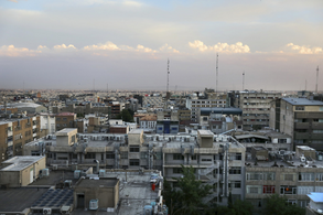
Zahedan like most of Zorasan's major cities suffers from severe air pollution, though it ranks as the most polluted in the country. In 2017, Zahedan was ranked the second most polluted major city in the world after Rongzhuo. 70% of the city's pollution is due to vehicles. The remaining 30% is due to industrial pollution. Zahedan also suffers from severe noise pollution, most of which is blamed on motorcycles, which are immensely popular with inhabitants. Zahedan is also considered as the strongest source of greenhouse gas emissions in Northern Coius. Enhanced concentration of carbon dioxide over the city (that are likely originated from the anthropogenic urban sources in the city) is easily detectable from the satellite observations throughout the year. The city's geography is widely blamed for exacberating the air pollution issue. Zahedan is bound in the north by the massive Soban mountain range that is stopping the flow of the humid Solarian wind from the north. As a result, thermal inversion that traps Zahedan's polluted air is frequently observed. The lack of humidity and clouds makes Zahedan a very sunny city. The UV radiations then combined with the existing pollutants significantly raise the level of the ozone.

So severe is the air pollution, that on average an estimated 36 people die each day as a result of pollution-related diseases, this has been known to significantly increase during instances of thermal inversion. In 2014, 867 people died during the second week of August as a result of increased pollution due to thermal inversion.
In 2015, the Zorasani federal government intervened to combat air pollution, introducing a strict "Clean Zone" around the central districts of the capital, while also explording the mass introduction of natural gas powered vehicles or electric vehicles. In 2017, the first electric buses were introduced, while city taxi firms were offered financial incentives to adopt electric vehicles. In 2018, a bicycle-sharing system was introduced across the city to promote cycling over vehicles. There have also been plans to raise people's awareness of the hazards of pollution. One method that is currently being employed is the installation of Pollution Indicator Boards all around the city to monitor the current level of particulate matter (PM10), nitrogen dioxide (NO2), ozone (O3), sulfur dioxide (SO2), and carbon monoxide (CO).
Water
One of the biggest environmental issues facing Zorasan as a country is the growing water shortage crisis. While scientists accept that climate change plays a role, it is the mismanagement of water resources by Zorasani industry and government that is most to blame. The biggest contributor to water shortages is the unsustainable consumption of drinking water by the country's largest cities, where due to geography most drinking water is diverted or channeled from outside sources.
Zahedan for its part derives much of its drinking water through a network of pipelines and canals, transporting water from natural aquifers and glacial springs in the XX Mountains in southern Pardaran and the southern states of Samrin and Armavand. The sustained expansion of heavy industry in Zahedan's outskirts pushed up demand for water, especially its petrochemical refining facilities. Yet, the city's population boom between 1980 and 1999 saw the greatest increases in demand, which were met with the expansion of the pipeline network, this resulted in the decline of avaliable water resources in the far-south of Zorasan. The diversion of millions of gallons of water per day to sustain Zahedan's growth is believed to have directly led to the Southern Zorasan water crisis.
Cityscape


Zahedan as a city is divided in three segments, the North (شمالاً; Shemal), the Core (صمیم; Sameem) and the South (جنوب; Janoob). Each segment has a distinct history, character and socio-economic setting owing to its history and process of development. For instance, the North is defined by its leafy and lush residential streets and is markedly more wealthier, with most streets housing large villas and luxurious apartment blocks. The Core is the historic city, much of which has been demolished and replaced, though important historic sites remain, such as the Grand Bazaar, numerous Mazars, palaces and Gorsanid era apartments. The Core is also home to federal government ministries, departments and agencies, including the federal legislature. The South is defined as a chaotic urban sprawal, with large tenement buildings and densely packed commercial areas, the south is the setting for the city's heavy industry and is dominated by a lower socio-economic strata of the population.
The North is defined mostly by its higher socio-economic status, with many affluent neighbourhoods and green spaces. The North is mostly located on the rising slopes of the Soban Mountain range, as such is significantly more green, lush and forested than the rest of the city, this played a key role in the development of the north as a mostly residential and tourist focused section of the city. The North's was greatly expanded during the 1980s and 1990s, as wealthy citizens from the southern side of the city, but also from other parts of the country migrated to the capital. Many of the affluent residential areas were constructed by nearby historic palaces, apartments and cultural sites. By the early 2000s, development of the north was halted due to the lack of suitable land for development, this in turn drove up property prices and enabled further development. North Zahedan has the highest concentration of billionaires in Northern Coius, with 111 recorded individuals at addresses in the north. The North, is also home to many high-end retailers, concentrated in Kamranieh Street in Niavaran, these also include high-end and award winning restaurants, spas, clinics and theatres. Jaddeh Ghadim district in the north houses numerous art galleries, musuems and some of the country's leading medical facilities.
The Core section of the city covers the entirety of the ancient city of Zahedan, though very few if any ruins from before the 14th century AD remain intact. Much of the Core in the present day is developed toward housing public complexes, especially the ministries, agencies and departments of the Zorasan federal government. The area also boasts much of the city's office space and mass retail malls and financial institutions. The Core contains some of the oldest buildings in the city and houses structures boasting early examples of Irfanic architecture, such as the Grand Bazaar, and the Grand Timcheh, an ancient sarai built in the 12th century. As such, the Core is also a major shopping and entertainment hub, housing the Zahedan Opera House, the Fatimeh Sandsari Theatre and the Javad Jahandar Cultural Centre. The historic expansion of Zahedan began from the Core districts, first toward the south and then in recent decades, toward the north, as such the Core is the most developed in terms of infrastructure and transport.
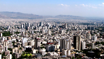
South Zahedan is the most densely populated and in some areas, overdeveloped. Over 70% of the city's 10 million inhabitants live in the Southern districts, with many individuals districts being constructed between the 1980s and the present. Some districts, such as Shahid Arabali, Shahid Mottahari and Farahzad, emerged during the early 1980s as slums, locally known as ravasakhtan (literally "built overnight"), referring to illegally constructed squatter buildings. At present, some ravasakhtan areas are being gradually demolished and replaced by modern mass-housing compounds. Moreover, large scale gentrification and urban renewal projects have been taking place, such as the one in Shahid Arabali. The city and federal government also has ambitious plans for an expansion of the city westward and southwards in conjunction with plans for a third airport; the new parts of the city will include four different settlements with specified urban functions, housing 1.5 million people.

An affluent neighborhood in Jaddeh Ghadim

Aerial photo of the densely packed Sattari district
High-rises of Niavaran district
The heavily developed Core section of Zahedan.
South Zahedan is defined by its "urban sprawal" of tenements and apartments.


Demographics
| Historical population | ||
|---|---|---|
| Year | Pop. | ±% |
| 1925 | 1,400,124 | — |
| 1937 | 1,000,351 | −28.6% |
| 1955 | 987,662 | −1.3% |
| 1965 | 1,874,361 | +89.8% |
| 1973 | 2,125,800 | +13.4% |
| 1975 | 2,336,417 | +9.9% |
| 1979 | 3,158,990 | +35.2% |
| 1982 | 4,000,214 | +26.6% |
| 1985 | 4,666,229 | +16.6% |
| 1991 | 5,760,232 | +23.4% |
| 1995 | 6,803,453 | +18.1% |
| 2005 | 9,100,755 | +33.8% |
| 2008 | 11,888,357 | +30.6% |
| 2010 | 12,336,571 | +3.8% |
| 2015 | 15,377,019 | +24.6% |
| 2019 | 17,998,378 | +17.0% |
| Source: Union Statistics Institute | ||
Throughout most of its history, Zahedan has ranked among the largest cities in the world. By 640 CE, Zahedan had somewhere between 400,000 and 500,000 people, from then on, it competed with Faidah (Khazestan) to be the largest city in the Irfanic world, and XXX, XXX and XXX, to be the world's largest city. Zahedan's decline during the late middle ages was followed by a brief return to growth before remaining stagnant at around 900,000 people between the 17th century and early 20th century. The later-half of the 20th century saw much of its population growth, propelling back into being one of the largest cities in the world, and the largest in North Coius.

The Union Statistics Institution (MAE) estimates that the population of the Union Capital Territory was 15,377,019 at the end of 2015, hosting 8.8 percent of the country's population. As of 2019, this estimate had risen to 17,998,378. As of the 2019 estimate, about 88% of the inhabitants were within city limits, up from 79% in the 2015 census and 50% in 1980. The remaining 22% as of the 2019 estimate, reside outside the official city limits in the wider Union Territory in satellite towns and the suburbs. The city's annual population growth of 3.45 percent ranks as one of the highest among the seventy-eight largest metropolises in the International Trade Organisation. The high population growth mirrors an urbanization trend across the country, however, a slight majority of the new inhabitants are moving to areas outside the city limits.
Zahedan experienced especially rapid growth during the second half of the 20th century, with its population increasing tenfold between 1980 and 2000. This growth in population comes, in part, from an expansion of city limits—particularly between 1980 and 1995, when the number of Zahedanis nearly doubled. The remarkable growth was, and still is, largely fueled by migrants from southern Pardaran seeking employment and improved living conditions, though a significant number of Badawiyans have begun to migrate from the eastern Union Republics in search of employment and better opportunities. The most densely populated areas tend to lie to the south and south-east, where new districts and developments have been built to accomodate the maximum number of citizens.