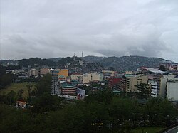
Takalik
Takalik | |
|---|---|
 Outskirts of Takalik | |
| Motto: Standing against adversity | |
| Country | |
| Template:Ajaw | Nojkabal |
| Kuchkabal | Ixnima |
| Takalik founded | c.1800 BC |
| Government | |
| • Type | Yajawil |
| • Body | Assemly of the Nine Terraces |
| • Castellum Assembly | 14 constituencies |
| Population (2016) | |
| • Metro | 600,000 |
| Demonym | Takalikeses |
Takalik, is the provincial capital of the Yajawil of Nojkabal and one of the oldest continuously inhabited city of the Mutul, alongside Sakal Witz. It's main ethnicties are the K'iche, Mam, and the Yok Kancheb. It's estimated population is around 400,000 people.
Located on the Southern plateau of the Central Highlands, it is the largest city of its Yajawil and one of the last large cities on the road to K'umakaj. Historically, the city was located on a ridge running north–south, bordered to the west by the Nima River and to the east by the X-chay River. The Nima river was especially important historically, as it was the main trade road between the Southern plateau and the Central Highlands to the north.
First settled around the second millenium BCE, it became one of the major cities of the Paol'lunyu Dynasty and then was the capital of the Hunal Dynasty. It would remain an important trade hub for the Chaan Dynasty and its easily defensible position and control over a region agriculturaly rich made it a sought-after stronghold during the period of crisis. It would slowly loose in importance during the K'uy Dynasty, but the conquest of the Mutul by the Ilok'tab made it an important junction between the K'uhul Ajaw in its capital of Kumakaj and its northern possessions, until the court migrated to K'alak Muul.
In modern days, Takalik has re-emerged as an important cultural, industrial and educational centre of the central-southern region.
Name and Etymology
Takalik, meaning "Standing" in K'iche, is the name that was given to the city by the southern invaders who discovered it for the first time. It has since then become the official name of the city. It's glyph-emblem, representing a moon goddess and a rock, is read as "Ab'j Xjaw" ([ʔaɓχ ʂχaw]), "Moon rock" in Yok kanb'itz, the oldest language from the region still spoken in modern days.
Geography
was built in a strategic site on a ridge running north–south, descending in a southwards direction, approximately 600 metres above sea level. This ridge is bordered on the west by the Nima River and on the east by the X-chay River. Because of its original situation, Takalik dominated over an important river crossing and other possible roads, which more than likely played a role in the foundation of the city.
Climate
It's located in an ecoregion classed as subtropical moist forest. The temperature normally varies between 21 and 25 °C. Takalik's region generally has a pronounced dry season when compared to other regions of the Mutul, but with high annual rainfall, between 2 to 4 millimetres with an average annual rainfall of 3,3 millimetres.
History
Pre-Mutul period
The changing styles of architecture and iconography suggest that the site has been occupied by changing ethnic groups. The archaeological finds of the deepest stratas presenting proofs of human habitations suggest that the population may have been affiliated with the culture named in the Mutuleses chronicles as the Chik'inli or "Westerners". Around 1500 BCE, the "Western" art styles were exchanged for Paol'lunyu styles. Presumably, that shift occured because of an influx an influx of ethnic "Mutun" people, a population change also hinted at in the surviving chronicles of the period. The {wp|Mam people|Yok Kancheb}} consider themselves the descendents of these first Mutuleses settlers.
Paol'lunyu Dynasty
War against Ujuxte
Before coming under the Paol'lunyu's domination, Takalik was a vassal state of Ujuxte, another important city of the Southern Hills at the time. Around 1180 BCE, the leader of the city abruptly changed, and the Chik'inli leader, possibly blood-related to the Ujuxte Ajaw, was replaced by a culturally-Mutulese lord. This rebellion of the Mutulese majority of the city led to a serie of bloody wars between Takalik and its ex-sovereign. The situation was resolved on Takalik's favour after they called Kaminyajunlyu, then a rising power in the Central Highlands, for help. Following this victory, Takalik became a vassal of Kaminyajunlyu and was free to expand its domination over the Southern Hills, taking Ujuxte's place as the local power.
Intensive Period
During the first half of the Paol'lunyu Dynasty, Takalik grew considerably but remained a loyal subject to the K'uhul Ajaw. It was originally one of a series of sites that were important commercial, ceremonial and political centres. It is apparent that it prospered from the production of cacao and from the trade routes that crossed the region.
At the time, Takalik covered an area greater than 4 square kilometres. The early style of monument at the site is closely linked to the style of monument at Kaminyajunlyu, showing mutual influence. This interlinked style spread to other sites that formed part of the extended trade and political network of which these two cities were the twin foci. Highly decorated boulders seems to have been a staple of the Takalikese style of the time. It's during that period that the Pink Pyramid was first erected over a sacred plateform of the previous era, to serve as a tomb for the Ajaw K'utz Chiman, possibly the Ajaw that led the rebellion and the independence wars against the city's Chik'inli overlords.
The end of the Intensive Period is marked by the rising tensions between Takalik, Izapak, and Oxwitik, leading to conflicts concerning trade and control over border regions. The quick succession of the Nakabe-Izapak War, Takalik-Izapak War, and the Oxwitik-Takabe War, are considered to mark the end of the Intensive Period and the degradation of the Paol'lunyu authority that would continue well into the Extensive Period.
