Noviisida County
Noviisida County
Novi'isida Kone | |
|---|---|
|
Images, from top down, left to right: Sar'aka Seaport, Sar'aka Post Office, Komo Market, Mount Hono'o, | |
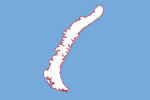
Noviisida County shown on map | |
| Country | |
| Island | Novi'isida |
| Administrative center | Sar'aka |
| Incorporated | 1997 |
| Government | |
| • Type | County |
| • Governor | Daniel Walker |
| Area | |
| • Total | 1,689 km2 (auto sq mi) |
| Elevation | 1,835 m (auto ft) |
| Population (2019) | |
| • Total | 1,600 |
| • Density | 0.95/km2 (2.5/sq mi) |
| Time zone | UTC-10 (KTT) |
| • Summer (DST) | UTC-9 (KTST) |
| ISO 3166 code | KT-WC |
Noviisida (/ˌnoʊviˈsidə/, /ˌnoʊviˈɪsɪdə/; Garetolian: [ˌnowiʔˈisida]) is the least populous county of Garetolia. The capital city of Sar'aka is the main transportation hub and is home to about 52% of the county's population. It is currently governed by Daniel Walker.
In the mid-1990s, the former Northern County was split between Northwestern Cona County, and Filan County; the latter had included the island of Novi'isida. Although the population had advocated for full county status, then-prime minister Kono Por'o and the Garetolian Government were hesitant to further split Filan as part of the Novi'isida Conflict. The island's small population generated concerns over whether it could sustain itself as a county. Nevertheless, Filan was split three years later and Novi'isida was incorporated as the ninth and final county of Garetolia.


