Bara ti'Emla
This article is incomplete because it is pending further input from participants, or it is a work-in-progress by one author. Please comment on this article's talk page to share your input, comments and questions. Note: To contribute to this article, you may need to seek help from the author(s) of this page. |
Bara ti'Emla | |
|---|---|
City | |
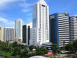
 Skyline of the Siqabara CBD | |
| Nickname(s): City of a Thousand Spires, The Wall of Emla | |
| Country | Trellin |
| Province | Emla |
| Founded | 472 BC |
| Government | |
| • Prince | Ezrím III Kaliot |
| • Mayor | Temba Sokath |
| Population (2014) | |
| • Urban | 5,849,366 (4th) |
| • Metro | 7,510,842 |
| Demonym | Barikot |
| Time zone | UTC−1 (TCT) |
| Area code | 022 |
Bara ti'Emla (Ahéri, meaning "fortress of Emla") is a major city in northern Trellin. It is the capital and most populous city in the province of Emla and the fourth most populous city in Trellin with a population of 5,849,366 and a metropolitan population of seven and a half million. Standing on top of the Cliffs of Mlíka, which rise over 150 metres above the Sea of Jajich, it is considered one of the most beautiful cities in Trellin, and its many towers and church steeples have earned it the nickname "City of a Thousand Spires".
The city was founded as the northernmost fortress of the Hyseran Empire, on the north bank of the Lasara river where it plunges over the granite cliffs into the sea below. From its founding to the fall of the Hyser, it remained an unconquered bastion of the north, becoming the heart of the independent Duchy of Emla from 811 until it joined the Trellinese Empire in 1532. During the Trellinese Civil War, between 1892 and 1899, Bara ti'Emla was a firmly Royalist stronghold, and its prince launched his own expeditions in the defence of northern Trellin.
Today Bara ti'Emla is a major economic centre and a hub of IT and pharmaceutical manufacture. It is an important transport link on the country's high speed rail and motorway networks and is served by two airports. In 2015 it hosted a major Astyrian peace negotiation between the ATO and EATA.
History
The city was originally founded as a frontier town of the Hyseran Empire guarding over the coast road from the north. It was at first known simply as Bara, Ahéri for 'fortress', despite lacking any significant defensive walls. The site's strategic value derived from its acropolis, which is only accessible from the south approach, as well as the unassailable granite cliff to the northwest and the river bend to the south and east. Because Bara controlled the last bridge over the Lasara river, it rapidly came to be a major trade focus in the north of the empire.
Immediately prior to the fall of Hysera in 811, Emla seceded from the empire. It remained amiable to the Kingdom of Trellin but came into conflict with Arimathea to the east, fighting wars over the cities of Dargai and Kzint. In 1312, Bara ti'Emla was invaded by Arimathean forces who perpetrated the Bara Massacre, killing hundreds of people inside the city.
Geography
The northwest coast of Emla is distinguished by sheer granite cliffs, which reach their greatest height around the city of Bara ti'Emla, climbing to 162 metres above the Sea of Jajich. Old Bara was built on an acropolis a short distance north of where the Lasara plunges 150 metres into the sea.
Economics
Bara ti'Emla's economy is largely based on the production of pharmaceutical and IT products, for which it is the largest centre in Trellin. As well as hosting a number of Astyrian companies, the headquarters of several major domestic pharmaceutical companies are located in the city. The central business district is in the Siqabara district, which is located outside the traditional cultural centre of the acropolis.
Tourism, both domestic and international, is an important part of the Barikot economy. The city centre receives over three million tourists annually.
