Cayenne (Province): Difference between revisions
No edit summary |
No edit summary |
||
| Line 1: | Line 1: | ||
{{Infobox | {{Infobox settlement | ||
| | | name = Cayenne | ||
| native_name = | |||
| | | native_name_lang = | ||
| | | settlement_type = [[Administrative District (Zamastan)|Province]] | ||
| | | image_skyline = | ||
| image_alt = | |||
| image_caption = | |||
| image_flag = | |||
| flag_alt = | |||
| image_seal = | |||
| | | seal_alt = | ||
| | | image_shield = | ||
| | | shield_alt = | ||
| | | etymology = | ||
| nickname = | |||
| | | motto = | ||
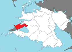
| | | image_map = A-Cayenne.png | ||
| | | map_caption = Location of Cayenne province in Zamastan. | ||
| | | pushpin_map = | ||
| | | pushpin_map_alt = | ||
| | | pushpin_map_caption = | ||
| | | pushpin_label_position = | ||
| | | coordinates = <!-- {{coord|latitude|longitude|type:city|display=inline,title}} --> | ||
| | | coor_pinpoint = | ||
| coordinates_footnotes = | |||
| | | subdivision_type = Country | ||
| | | subdivision_name = [[Zamastan]] | ||
| | | subdivision_type1 = Capital and largest city | ||
| | | subdivision_name1 = [[Fougere]] | ||
| | | subdivision_type2 = | ||
| | | subdivision_name2 = | ||
| subdivision_type3 = | |||
| subdivision_name3 = | |||
| established_title = Province | |||
| established_date = July 28, 1832 | |||
| founder = | |||
| seat_type = | |||
| seat = | |||
| government_footnotes = | |||
| government_type = | |||
| | | governing_body = | ||
| | | leader_party = [[Blue Conservative Party (Zamastan)|BCP]] | ||
| | | leader_title = [[Governor (Zamastan)|Governor]] | ||
| | | leader_name = [[Noah Altonbaire]] | ||
| | | leader_title1 = | ||
| | | leader_name1 = | ||
| | | leader_title2 = | ||
| | | leader_name2 = | ||
| | | leader_title3 = | ||
| | | leader_name3 = | ||
| | | leader_title4 = | ||
| | | leader_name4 = | ||
| | | area_total_km2 = | ||
| | | area_land_km2 = | ||
| | | area_water_km2 = | ||
| | | area_urban_km2 = | ||
| area_rural_km2 = | |||
| | | area_metro_km2 = | ||
| | | area_blank1_km2 = | ||
| | | area_blank2_km2 = | ||
| | | elevation_footnotes = | ||
| | | elevation_m = | ||
| | | population_as_of = 2020 | ||
| | | population_footnotes = | ||
| | | population_total = 10,617,000 | ||
| | |||
| | |||
| | |||
| | |||
| | |||
| | |||
| | |||
| | |||
| | |||
| | |||
| | |||
| | |||
| | |||
| | |||
| | |||
| | |||
| | |||
| | |||
| | |||
| | |||
| | |||
| | |||
| | |||
| | |||
}} | }} | ||
'''Cayenne''' is an [[Administrative District (Zamastan)| | '''Cayenne''' is an [[Administrative District (Zamastan)|province]] of [[Zamastan]], bordered by the provinces of [[Redeemer’s Land]] and [[Verdesia (Province)|Verdesia]] to the east, the [[Olympic Ocean]] to the west, [[Rio Palito]] and a shoreline with [[Lake Greening]] to the south. The border between Cayenne's capital of [[Fougere]] and the Rio Palitoan capital of [[San Beausoliel]] is the busiest border crossing in [[Euronia]]. Fougere is the province's largest city, with other major cities including [[Alabaster]], [[Cole Harbor]], [[Macenco]], [[Scarham]], and [[Antigonish]]. | ||
The provincial GDP is derived of services (about half being government services and public administration) 43%; construction, manufacturing, and utilities 24%; real estate rental 12%; wholesale and retail 11%; agriculture, forestry, fishing, hunting, mining, oil and gas extraction 5%; transportation and warehousing 5%. Tourism is also a major economic driver, employing 9% of the workforce. Beaches on both the oceanic and lake shores are among the most popular in the country, and other popular tourist sites include [[Falinnis National Park]], Estege Rocks, and [[Vongane|New Vongane]]. | |||
==History== | ==History== | ||
Revision as of 17:48, 24 August 2022
Cayenne | |
|---|---|
 Location of Cayenne province in Zamastan. | |
| Country | Zamastan |
| Capital and largest city | Fougere |
| Province | July 28, 1832 |
| Government | |
| • Governor | Noah Altonbaire (BCP) |
| Population (2020) | |
| • Total | 10,617,000 |
Cayenne is an province of Zamastan, bordered by the provinces of Redeemer’s Land and Verdesia to the east, the Olympic Ocean to the west, Rio Palito and a shoreline with Lake Greening to the south. The border between Cayenne's capital of Fougere and the Rio Palitoan capital of San Beausoliel is the busiest border crossing in Euronia. Fougere is the province's largest city, with other major cities including Alabaster, Cole Harbor, Macenco, Scarham, and Antigonish.
The provincial GDP is derived of services (about half being government services and public administration) 43%; construction, manufacturing, and utilities 24%; real estate rental 12%; wholesale and retail 11%; agriculture, forestry, fishing, hunting, mining, oil and gas extraction 5%; transportation and warehousing 5%. Tourism is also a major economic driver, employing 9% of the workforce. Beaches on both the oceanic and lake shores are among the most popular in the country, and other popular tourist sites include Falinnis National Park, Estege Rocks, and New Vongane.