Miersa: Difference between revisions
Jump to navigation
Jump to search
No edit summary |
No edit summary |
||
| Line 14: | Line 14: | ||
| languages = | | languages = | ||
| demonym = Miersan | | demonym = Miersan | ||
| capital = {{unbulleted list|[[Żobrodź]] ([[Miersan Commonwealth|historical]])|[[ | | capital = {{unbulleted list|[[Żobrodź]] ([[Miersan Commonwealth|historical]])|[[East Żobrodź]] ([[East Miersa]])|[[West Żobrodź]] ([[West Miersa]])}} | ||
| legislature = [[General Congress of East Miersa|General Congress]] ([[East Miersa]])<br/>[[National Assembly of West Miersa|National Assembly]] ([[West Miersa]]) | | legislature = [[General Congress of East Miersa|General Congress]] ([[East Miersa]])<br/>[[National Assembly of West Miersa|National Assembly]] ([[West Miersa]]) | ||
| area_km2 = 401,533 | | area_km2 = 401,533 | ||
| Line 45: | Line 45: | ||
| HDI_year = | | HDI_year = | ||
| today = | | today = | ||
| leader_title1 = [[ | | leader_title1 = [[Chairperson of the Presidium of East Miersa|Presidium Chairperson of East Miersa]] | ||
| leader_name1 = [[Anna Wlodarska]] | | leader_name1 = [[Anna Wlodarska]] | ||
| leader_title2 = [[President of West Miersa]] | | leader_title2 = [[President of West Miersa]] | ||
| Line 51: | Line 51: | ||
}} | }} | ||
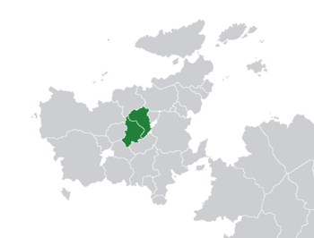
'''Miersa''' ({{wp|Polish language|Miersan}}: ''Mierska'') is a historical nation in [[Euclea|central Euclea]] with indeterminate borders, but generally bordered by [[Vedmed]] and [[Narozalica]] to the west, [[Velzemia]] and [[Swetania]] to the north, [[Aimilia]] and [[Gaullica]] to the east and [[Minilov]] to the south. Since the conclusion of the [[Great War (Kylaris)|Great War]] in 1936, Miersa has been divided between two sovereign states according to the [[Godfredson Plan]]. These are the [[East Miersa|Miersan | '''Miersa''' ({{wp|Polish language|Miersan}}: ''Mierska'') is a historical nation in [[Euclea|central Euclea]] with indeterminate borders, but generally bordered by [[Vedmed]] and [[Narozalica]] to the west, [[Velzemia]] and [[Swetania]] to the north, [[Aimilia]] and [[Gaullica]] to the east and [[Minilov]] to the south. Since the conclusion of the [[Great War (Kylaris)|Great War]] in 1936, Miersa has been divided between two sovereign states according to the [[Godfredson Plan]]. These are the [[East Miersa|Miersan Federative Council Republic]] in the east and the [[West Miersa|Miersan Sotirian Republic]] in the west. [[Żobrodź]], the historical capital, is also divided into [[East Żobrodź|east]] and [[West Żobrodź|west]]. | ||
Revision as of 10:15, 10 November 2021
Miersa Mierska | |
|---|---|
|
Flag | |
Anthem:
| |
 | |
| Capital | |
| Official languages | Miersan |
| Demonym(s) | Miersan |
| Government | |
| Anna Wlodarska | |
| Sylwester Wrzesiński | |
| Legislature | General Congress (East Miersa) National Assembly (West Miersa) |
| Establishment | |
| 1257 | |
| 1623 | |
| 1687 | |
| 1936 | |
| 1982 | |
| Area | |
• Total | 401,533 km2 (155,033 sq mi) |
| Population | |
• 2017 estimate | 38,159,000 |
• Density | 95.03/km2 (246.1/sq mi) |
| Internet TLD |
|
Miersa (Miersan: Mierska) is a historical nation in central Euclea with indeterminate borders, but generally bordered by Vedmed and Narozalica to the west, Velzemia and Swetania to the north, Aimilia and Gaullica to the east and Minilov to the south. Since the conclusion of the Great War in 1936, Miersa has been divided between two sovereign states according to the Godfredson Plan. These are the Miersan Federative Council Republic in the east and the Miersan Sotirian Republic in the west. Żobrodź, the historical capital, is also divided into east and west.
