Sohar: Difference between revisions
No edit summary |
No edit summary |
||
| Line 15: | Line 15: | ||
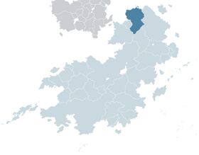
|map_caption = Location of Sohar (dark blue) in [[Coius]] (light blue) | |map_caption = Location of Sohar (dark blue) in [[Coius]] (light blue) | ||
|image_map2 = | |image_map2 = | ||
|capital = [[ | |capital = [[Tarihi]] | ||
| | |largest_city = capital | ||
|official_languages = {{wp|Arabic language|Rahelian}} | |||
|ethnic_groups = {{wp|Arabs|Rahelian}} (82%)<br>[[Nise|Anniserian]] (10%)<br>{{wp|Jews|Atudite}} (8%)<br>Other (1%) | |ethnic_groups = {{wp|Arabs|Rahelian}} (82%)<br>[[Nise|Anniserian]] (10%)<br>{{wp|Jews|Atudite}} (8%)<br>Other (1%) | ||
|ethnic_groups_year = 2019 | |ethnic_groups_year = 2019 | ||
| Line 73: | Line 74: | ||
|cctld = .sh | |cctld = .sh | ||
}} | }} | ||
'''Sohar''' ({{wp|Arabic language|Rahelian}}: صحار), officially the '''Republic of Sohar''' ({{wp|Arabic language|Rahelian}}: جمهورية صحار), is a country in the [[Rahelia]] region of [[Coius]]. With a population of over 25 million as of 2021, it is the 15th most populous nation in Coius. Located close to the border between Rahelia and [[Bahia]], it is the northernmost nation on the Coian mainland, and is bordered by the Gulf of Assonaire to the north and east, [[Nise]] and [[Tsabara]] to the southwest, x to the south, and xx to the east. | |||
Sohar was one of the first areas in Rahelia to be inhabited by humans, with the earliest human settlements in the region dating back X years. The country's coast was first explored by !Phonecian traders in the ninth century BCE, leading to the creation of a network of coastal city-states that eventually united to form the merchant state of | |||
Revision as of 16:24, 25 February 2021
This article is incomplete because it is pending further input from participants, or it is a work-in-progress by one author. Please comment on this article's talk page to share your input, comments and questions. Note: To contribute to this article, you may need to seek help from the author(s) of this page. |
Republic of Sohar Rahelian: جمهورية صحار | |
|---|---|
Motto:
| |
Anthem:
| |
 Location of Sohar (dark blue) in Coius (light blue) | |
| Capital and largest city | Tarihi |
| Official languages | Rahelian |
| Ethnic groups (2019) | Rahelian (82%) Anniserian (10%) Atudite (8%) Other (1%) |
| Religion (2019) | Irfan (92%) Atudism (7%) Other (1%) |
| Demonym(s) | Soharan |
| Government | Unitary dominant-party semi-presidential republic |
| Hamid el-Bari | |
• Prime Minister | Asmar al-Kaba |
| Legislature | Parliament |
| People's Council | |
| National Assembly | |
| Establishment | |
• Independence from Estmere | 9 September 1948 |
• Admission to the Community of Nations | 14 October 1953 |
• Current Constitution | 15 June 1985 |
| Area | |
• Total | 1,534,132.2 km2 (592,331.8 sq mi) |
• Water (%) | 1.2% |
| Population | |
• 2021 estimate | 25,159,042 |
• 2019 census | 24,675,988 |
• Density | 16.4/km2 (42.5/sq mi) |
| GDP (PPP) | 2021 estimate |
• Total | $373 billion |
• Per capita | $14,864 |
| GDP (nominal) | 2020 estimate |
• Total | $103 billion |
• Per capita | $4,103 |
| Gini (2018) | 47.8 high |
| HDI (2019) | 0.728 high |
| Currency | Soharan Dinar (SHD) |
| Date format | dd-mm-yyyy (AD) |
| Driving side | left |
| Calling code | +103 |
| Internet TLD | .sh |
Sohar (Rahelian: صحار), officially the Republic of Sohar (Rahelian: جمهورية صحار), is a country in the Rahelia region of Coius. With a population of over 25 million as of 2021, it is the 15th most populous nation in Coius. Located close to the border between Rahelia and Bahia, it is the northernmost nation on the Coian mainland, and is bordered by the Gulf of Assonaire to the north and east, Nise and Tsabara to the southwest, x to the south, and xx to the east.
Sohar was one of the first areas in Rahelia to be inhabited by humans, with the earliest human settlements in the region dating back X years. The country's coast was first explored by !Phonecian traders in the ninth century BCE, leading to the creation of a network of coastal city-states that eventually united to form the merchant state of

