Vitruvia
This article is incomplete because it is pending further input from participants, or it is a work-in-progress by one author. Please comment on this article's talk page to share your input, comments and questions. Note: To contribute to this article, you may need to seek help from the author(s) of this page. |
Confederacy of Vitruvia | |
|---|---|
 Flag
 National Coat of Arms
| |
Motto: "Per a republica chì si alza, ùn ci hè nunda di supiriore" "For the rising republic, there is nothing higher" | |
Anthem: Inno della Virtuviu "Hymn of Vitruvia" | |
 Location of Vitruvia (in light green), within Euclea (light grey) | |
 | |
| Capital | Incudine |
| Government seat | Castellu |
| Official languages | Vitruvio Novalian |
| Recognised regional languages | Vespasian |
| Ethnic groups (2019) | Vitruvio (61%) Novalian (23%) Vespasian (6%) Piraean (4%) Zorasani (2%) Gaullican (2%) Logudorese (1%) |
| Religion (2019) | 80.3% Solarian Catholicism 14.6% Agnosticism and Irreligious 2.3% Irfan 1.6% Atudism 1.2% Other |
| Demonym(s) | Vitruvio / Vitruvian |
| Government | Unitary semi-presidential constitutional republic |
• President | Tommas Bezzina |
• Prime-Minister | Zakkarija Laviera |
| Legislature | Republic's Assembly |
Vitruvia, officially the Republic of Vitruvia, (Vitruvio: Republica di Vitruviu, pronounced: vɪtɹˈuːvi͡ə - IPA) is a sovereign parliamentary republic in southern Euclea, made up of 18 provinces. It only shares a single land border, with Etruria to the north, however is bordered by both the Solarian Sea to the east and the Acheloian Sea to the west. The country's official languages are Vitruvio and Novalian, with Vespasian acting as an official language in the province of Catturaterra.
The four largest cities in the nation consist of Incudine, Fracissia, Castellu and Sanpolo. Incudine is the national capital in accordance with the constitution, as well as being the most populous city. Despite this, Castellu holds the seat of the Parlementu, Cabinet as well as the Supreme Court. Vitruvia, due to it's location, is also home to some of the busiest seaports in all of Euclea, including at Fracissia.
Etymology

The name "Vitruvia" originates from the Solarian architect Vitruvius who was widely regarded as the founder of Solarian architecture. Vitruvius helped in originating the Solarian idea that all buildings should have firmitas, utilitas, and venustas ("strength", "utility", and "beauty") which was later taken up by general Solarian architecture. Many of the works attributed to Vitruvius ended up in modern day Vitruvia during a period of latinizaton, which lead to the Solarian name for the land "Vitruvio".
This name later replaced the native name for the land, roughly known as "Muntidimare", over the years which it was inhabited by the Solarian Empire. When the Solarian Empire collapsed, the Vitruvian Maritime Republic formed and kept the name pinned by the Solarians.
History
Prehistory
- -Vitruvia has been inhabited consistently for around 11,000 years.
- -Vitruvia was visited early by !Phoenicians who brought with them an early form of the !Semitic language
Early History
- -Vitruvia was entirely colonised by the Piraean Terrtiries in 750BC that lasted until 200BC. Due to it’s proximity to the antipode of hte empire, north-western Vitruvia became subject to Piraeanisation (the process of Piraean architecture and cultural customs being introduced to Vitruvia) which can still be seen in modern day in ruins throughout the coast.
- -The land is invaded by Marolevic tribes from the north however the culture and language splits due to influence from an influx of refugees from Rahelia. This gave way for the beginning of the evolution of the Vitruvio language.
- -From 89 BC-420 AD Vitruvia was governed under the Solarian Empire. During this time a period of Solarianisation began, which also involved the introduction of an early Sotirianity in 48CE. This would eventually result in the conversion of native Vitruvio people following the Solarian Catholic Church.
- -Upon the collapse of the Solarian Empire, Vitruvia became a land filled with small-scale city states and kingdoms ruled by local families of nobility. The most notable of these kingdoms, and the largest, was the Regnu Imperiale which modelled itself on the fallen Solarian Empire and was centred around the city of Impericita. The Vitruvio States would interact with the fragmented Etrurian and Piraean states and kingdoms.
- -Over 250 years later, in 732AD, a merchantile republic had formed around the city of Fracissia. Fracissia had established itself with a thriving slave trade. A united Fracissia, it began to have influence and control over a majority of the eastern coast of Vitruvia and became incredibly wealthy due to it's advantageous trade position inbetween east and west Euclea.
Early Modern History
- -1466: Povelia, due to it's rapid expansion, occupies all of western and central Vitruvia, leaving only the Maritime Republic of Vitruvia left independent. Through Povelian occupation of the peninsula, the Povelians managed to dominate the Euclean-Coian trade, establishing commercial outposts and colonies as far west as Satria.
- -16th Century: The Maritime Republic flourishes, with trade expanding the wealth of the cities and giving Vitruvia the nickname "The Golden Coastline" due to the flashing architecture of it's eastern cities. The Maritime Republic saw mostly diplomatic relations with neighbouring Povelia, besides from in 1510 with the short "War of Cielo D'oro".
- -18th Century: Upon the collapse of Povelia, the Viturvio land is incorporated into the Etrurian First Republic which saw uproar from the native Vitruvio population who still existed as the majority ethnic group south of the Tarantines.
- -19th Century: The Vitruvian Maritime Republic finally falls to the Etrurian United Kingdom in 1801, following the Treaty of Surrender. and was partitioned into the self-governed "Etrurian Vitruvia".
Modern History
- -1927: During the Great War, Vitruvia remained under Etrurian occupation and acted as a puppet state. Around 200,000 Viturvian men were sent to fight for Etruria and the Grand Alliance.
- -1944: As part of the Solarian War, Viturvians began the Viturvian Revolution which resulted in a victory and independence for the country which was supported by the CoN.
- -1946-55: Following the devastation of the Solarian War, Vitruvia saw a period of economic struggle with much of the northern portion of the nation needing rebuilding. This caused a period of political instability.
- -1955-61: Under President Bastia Simeoni, Vitruvia saw democratic and economic reform that gained the nation much better political relations in Euclea.
Politics and Government
Geography


Vitruvia occupies the southern end of the $Etrurian Peninsula and lies completely within the northern hemisphere. This means Vitruvia occupies the southern-most point of Euclea at Finu di Terra as well as the southern-most city on the continent at Castellu.
Vitruvia is split from it's only land neighbour, Etruria, to the north by the Tarantine Mountains as well as the River Brille to the east which runs down through and disgorges in the Brille estuary before dispersing into the Solarian Sea. The northern landscape is mostly mountainous, with the exception of flatter ground in small pockets in the east and west. The mountainous region contains several plateaus and river valleys whereas in the southern regions, such as the Affiero and Solaritenjo regions, are characterized by containing rolling plains.
Vitruvia's highest point lies at Mount Frassini, an ancient volcano with a height of 2,166 m (7106.3 ft), which is located in the Tarantine Mountains. Other mountains, including the Coperta di Neve peak, are important as a seasonal attraction for skiers as well as for winter sports enthusiasts.

An aerial view of the Ol d'i Mari cave in southern Vitruvia
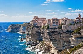
A coastal town located on a cliffside in south-west Vitruvia
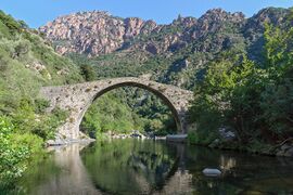
The River Brille flowing through the outer Tarantine Mountains.
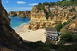
The Mariana Beach, ranked top 10 beaches in Euclea in 2018.
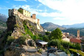
The Maupertuis Citadel in Casamontagna.
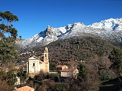
Saint-Nicolas church in Corte.


,_by_Klugschnacker_in_Wikipedia_(90).JPG)


Biodiversity
,_Almuradiel,_Ciudad_Real,_Espa%C3%B1a,_2021-12-19,_DD_07.jpg)
Due to it's geographical and climatic location - located in the middle of the Solarian and the Acheloian - Vitruvia has a very diverse and split biodiversity in both land and sea. It's biodiversity can also be attributed to it's range of biotopes and habitats as well as it's proximity to Coius. Vitruvia contains 5 terrestrial ecoregions: Tarantine mixed forests, Vitruvian sclerophyllous and semi-deciduous forests, Etrurian deciduous forests, Southern Vitruvian Solarian sclerophyllous and mixed forests and the South Tarantine montane forests.
The vegetation of Vitruvia is incredibly varied due to factors including the geographical terrain, the climate, as well as the latitude. In 2019, Vitruvia was given a score of 0.98 on the Forest Landscape Integrity Index. Over 19% of it's total land area is part of the Viturvia 200 Project, made up of 68 special conservation areas and over one hundred protected wildlife habitats.
Economy
Demographics
Culture
Architecture
Vitruvian architecture reflects it's culturally diverse history and influence from other Solarian cultures and architectural styles which have been brought to Vitruvia over the course of history. Some of Vitruvia's earliest inhabitants, prior to Piraean occupation, constructed the Giantess which stands as one of the oldest manmade freestanding structures in the world.